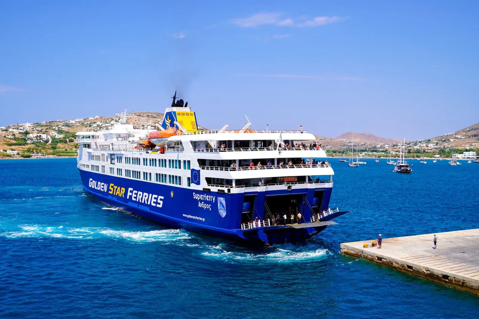
Map of the Cyclades: the islands, and the boats between them
Around 220 islands in the middle of the Aegean, 24 of them lived on. Knowing where they sit is half the problem. The other half is which ones have a boat between them, and that is what this map draws.
Every map of the Cyclades shows you the same thing: dots in a sea, correctly placed and completely useless for planning. The islands are not connected in the order they appear. Mykonos and Milos are 100 km apart and a day of travel; Naxos and Santorini are 90 km apart and 90 minutes. The map below draws the boats rather than the distances, which is the only version of this map that answers the question you actually have.
The network
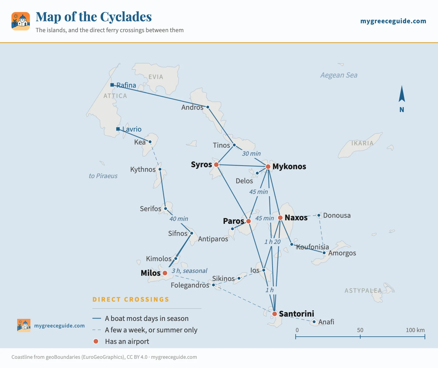
Paros sits at the centre of the network with more direct links than any other island, which is why it turns up in almost every itinerary whether or not anyone meant to go there. The island map shows where that puts you, since the quay everything calls at is not the town most people sleep in. The western chain is nearly a separate country, joined to the rest by one dashed line that only exists in summer. And the islands with the most boats, Paros, Naxos, Mykonos and Santorini, are also the ones with runways, so the network and the flight map pile up in the same places instead of covering for each other.
Where the Cyclades archipelago actually sits
The group occupies the middle of the Aegean, south-east of Athens. Kea, the nearest island, is about 60 km from the Attic coast. From there the archipelago runs roughly 200 km south-east to Santorini and Anafi, and about 150 km across at its widest, from Kythnos in the west to Amorgos in the east. Everything in it fits inside a box smaller than Sicily, which is why the distances surprise people: the islands are close, and the boats between them are not always there.
The name is older than any of it. Kyklos is Greek for circle, and the ancients understood the group as a ring drawn around Delos, the sacred island at its centre where Apollo and Artemis were held to have been born. Delos is still uninhabited, still at the geometric middle of the group, and still visited only by day boat from Mykonos.
The neighbours matter as much as the group itself, because they are what the Cyclades are constantly confused with. Crete is 120 km south of Santorini across open sea. The Dodecanese, with Rhodes and Kos, run down the Turkish coast well to the east. The Ionian islands are on the other side of the country entirely, reached from different airports. The six groups laid out across both seas is worth two minutes if any of those names are still interchangeable to you.
Every inhabited island, on the chain that serves it
Alphabetical lists of the Cyclades exist everywhere and help nobody. These are the 24 islands with a year-round population, grouped the way the boats group them, which is the only arrangement that tells you anything about a trip.
Northern
Out of Rafina
- AndrosBig, green and walked rather than swum. Shipowners' mansions, and almost no foreign visitors
- TinosThe pilgrimage island, with 800 dovecotes and a marble-carving tradition still working
- MykonosThe night out. Flat, brown and expensive by daylight
- SyrosThe capital of the Cyclades, and a working town with an opera house rather than a resort
- DelosUninhabited. The sanctuary the whole group is named after, visited from Mykonos
Central
Out of Piraeus
- ParosThe junction. Everything passes through, and Naoussa is the best evening outside Mykonos
- AntiparosTen minutes across the water from Paros, small enough to walk out of
- NaxosThe largest, 430 km², with a mountain range, real villages and long sandy beaches
- IosYoung, loud and genuinely beautiful in the mornings before anyone is up
- SantoriniThe caldera. Two or three nights at the end of a trip, not a week
- KoufonisiaSmall Cyclades. One village, no cars worth mentioning, water the colour of a swimming pool
- SchinoussaSmall Cyclades. Two hundred people and a handful of beaches
- IrakliaSmall Cyclades. The quietest of the four, with a cave and one road
- DonousaSmall Cyclades. The most isolated island in the group with a boat to it
- AmorgosThe far east. A cliff monastery, and the best walking in the Cyclades
- ThirasiaThe far wall of the Santorini caldera, broken off in the same eruption. Three hundred people and one boat
- AnafiPast Santorini and nearly at the Dodecanese. One village, and a rock like Gibraltar
Western
Out of Piraeus and Lavrio
- KeaAn hour from Lavrio, full of Athenians at weekends and nobody else ever
- KythnosHot springs, a sandbar beach at Kolona, and the cheapest rooms in the group
- SerifosA chora stacked on a cone above the port, and one of the great Cycladic skylines
- SifnosThe food, and 100 km of restored stone paths between the villages
- KimolosThirty minutes from Milos and forty years behind it
- MilosA collapsed volcano. Sarakiniko, Kleftiko, and coves you can only reach by boat
- FolegandrosA chora on a 200 m cliff. The quiet one people come back to
- SikinosBetween Folegandros and Ios, with terraced vineyards and almost no beds
Underlined islands have an airport. Delos is the one entry with nobody living on it, and it is the sanctuary the whole group is named after. That leaves 24 islands with a year-round population; the other two hundred or so are rock, chapel and goats.
What sails where, and how long it takes
The map says a crossing exists. It cannot say how long you are at sea or how many chances a day you get, and those two numbers are what turn a line on a map into a plan. Times run from the fast catamaran to the conventional ferry, because both are sold on the same booking page at very different prices. Frequencies are July and August, when they are at their highest and their most stable.
| Crossing | At sea | Boats a day | Worth knowing |
|---|---|---|---|
| The central chainThe busy half of the group. Every crossing here has several boats a day and a choice between a fast catamaran and a conventional ferry. | |||
| Paros to Naxos | 30 to 60 min | 6 to 10 | The shortest useful hop in the Cyclades, and the one that makes a two-island week easy |
| Paros to Antiparos | 10 min | Every 30 min | A local shuttle from Pounta rather than a ferry, and it takes cars |
| Naxos to Ios | 1 h to 1 h 45 | 4 to 6 | Fast boats do it in an hour, the big ferries take closer to two |
| Ios to Santorini | 45 min to 1 h 30 | 4 to 6 | The last leg of the central line, and the one everybody takes southbound |
| Naxos to Santorini | 1 h 40 to 3 h | 3 to 5 | Direct, skipping Ios. Worth it if you are not stopping |
| Paros to Ios | 1 h 30 to 2 h 30 | 3 to 5 | Skips Naxos, which is the point if Naxos is where you have just been |
| Syros to Paros | 1 h to 1 h 30 | 2 to 4 | The way onto the central line from the northern one without going back to Athens |
| The northern lineAndros, Tinos and Mykonos sit on a string that starts at Rafina, on the far side of Athens, twenty minutes from the airport. | |||
| Rafina to Andros | About 2 h | 3 to 5 | The mainland end. Andros has no airport and this is how everyone arrives |
| Andros to Tinos | 1 h 30 to 2 h | 3 to 5 | Same boats continuing south, so the connection is the sailing you are already on |
| Tinos to Mykonos | 15 to 40 min | 8 to 12 | The densest crossing in the group. Two ports on Mykonos, check which one your ticket says |
| Tinos to Syros | 30 to 50 min | 4 to 6 | Syros is the administrative capital and busier in winter than in August |
| Syros to Mykonos | 30 to 50 min | 3 to 5 | Closes the northern triangle, and lets you skip Tinos in either direction |
| Mykonos to Delos | 30 min | 3 to 5 | An excursion boat, not a ferry. Nobody sleeps on Delos and the last boat back is early |
| The western lineKythnos down to Milos, quieter and cheaper, with no fast boats on most of it and no airport until you reach the bottom. | |||
| Lavrio to Kea | About 1 h | 3 to 6 | Kea is reached from Lavrio and nowhere else, which is why it stays quiet |
| Kythnos to Serifos | About 1 h | 1 to 2 | One or two boats a day, and the timetable thins sharply outside August |
| Serifos to Sifnos | 40 min to 1 h | 2 to 3 | The easiest pair on the line, and the two islands suit each other |
| Sifnos to Kimolos | 1 h to 1 h 30 | 1 to 2 | Not every sailing calls at Kimolos, so read the stops before you book |
| Sifnos to Milos | 1 h to 1 h 45 | 2 to 3 | The main run down to the end of the line |
| Kimolos to Milos | 30 min | 4 to 6 | A small local boat between Pollonia and Psathi, and it carries cars |
| The Small Cyclades, off NaxosFour inhabited specks east of Naxos, served by one boat that works its way round them. Naxos is the door and there is no other. | |||
| Naxos to Koufonisia | 1 h to 2 h | 1 to 3 | The busiest of the four, and the only one with a real choice of rooms |
| Koufonisia to Amorgos | 1 h to 1 h 30 | 1 to 2 | Lands at Katapola or Aegiali, and the two are 40 minutes apart by road |
| Naxos to Donousa | 1 h 30 to 2 h 30 | 3 to 5 a week | The most isolated of the group. A cancelled boat here costs you two days |
| Across the linesThe crossings that let you change corridor without going back to Athens. All of them are seasonal, all of them are thin, and all of them are the first to be cancelled in a strong meltemi. | |||
| Mykonos to Santorini | 2 h to 3 h | 3 to 5 | The exception: busy, fast and direct. Also the most cancelled route in the Aegean |
| Milos to Folegandros | About 3 h | 3 to 5 a week | The bridge between the western and central lines, and it runs June to September |
| Folegandros to Santorini | 1 h to 2 h | 4 to 6 | Reliable enough in season, and the easiest way off the western line |
| Sikinos to Ios | About 30 min | 3 to 5 a week | Short, and on a timetable built for the islanders rather than for visitors |
| Milos to Santorini | 2 h 30 to 4 h | 2 to 4 a week | Direct on a handful of summer sailings. Not on the map because most weeks it goes via Folegandros |
| Santorini to Anafi | 1 h to 1 h 30 | 4 to 6 a week | The end of the line east. Anafi has one village and no airport |
The pattern to take from the table is the fall-off. On the central chain you get six to ten boats a day and a missed sailing costs you an hour. On the western chain you get one or two, and a missed sailing costs you a night. On the seasonal links across the chains you get three to five a week, and a cancelled sailing costs you the rest of the itinerary. The same 90 minutes at sea means three completely different things depending on which line it sits on.
Where the network is thickest
Which islands actually combine
Put a finger on any two islands on the map and count the lines between them. One line is a holiday. Two lines is a travel day. No line is a mistake you find out about at the port.
Paros, Naxos and Santorini is the week that works for most people, in that order, finishing at the caldera and flying home from it. The run down from Piraeus to Paros opens it, then two short hops. Add Ios between Naxos and Santorini if you have ten nights and want a fourth.
Milos, Sifnos and Serifos is the same week on the western chain for two thirds of the money, with fewer boats and no crowd. Milos is the long leg from Athens and the one to book first, then work back up the chain towards Piraeus rather than down it, so the thin end of the timetable is behind you.
Mykonos and Santorini is the trip half the visitors to Greece take, and the map shows why it is also the one most often broken: it is a long open crossing on fast boats that stop sailing in a strong wind while the big ferries carry on. Where you land on Santorini and where you sleep are also further apart than anyone expects.
What does not combine, whatever the distance says: Mykonos with anything on the western chain, Kea with anything at all, and Amorgos with a flight home the next morning. If you are still choosing rather than routing, the guide to which island suits which kind of week is the page to read alongside this one.
Using this map once you are out there
A network map is a picture of what is possible, not a promise about Thursday. The wind decides, not the timetable. The meltemi blows down the Aegean through July and August and it does one specific thing to this map: it takes out the dashed lines first, then the fast boats, and leaves the thick solid lines and the big conventional ferries running. An itinerary built entirely on solid lines survives a windy week. One that depends on a single dashed crossing does not.
Two habits follow from that. Never put a crossing on the day you fly, because a cancelled sailing turns into a missed flight and the insurance rarely calls weather a covered reason. And on any leg with one boat a day, hold the ticket before you leave home rather than at the quay, since the conventional ferries fill with cars and the fast boats fill with people, often several days out. How Greek ferries work, company by company covers the booking side, which is messier than the sailing side.
One last thing the map is honest about. Outside roughly April to October most of this network stops existing. The western chain drops to a couple of sailings a week, the seasonal links vanish altogether, and only Santorini, Mykonos, Naxos, Paros and Syros keep enough boats and enough open doors to be worth the trip. A winter map of the Cyclades would be this one with three quarters of the lines rubbed out.
Questions people ask about the map of the Cyclades
Where are the Cyclades islands located?
In the middle of the Aegean, south-east of Athens, between roughly 36 and 38 degrees north. The group starts about 60 km from the Attic coast at Kea and runs 200 km south-east to Santorini and Anafi, with Amorgos marking the eastern edge before the Dodecanese begin. Crete lies 120 km south of Santorini across open water, and the Turkish coast is well to the east. The name comes from the Greek kyklos, a circle, because the ancients saw the islands as a ring around the sanctuary of Delos.
How many islands are in the Cyclades?
Around 220, depending on how small a rock you are willing to count, and only 24 have people living on them all year. Of those 24, about a dozen have enough rooms, food and boats to hold a holiday. The rest range from Donousa, with a couple of hundred residents, to islets with a chapel and a shepherd. Delos is the odd one out: it is uninhabited by law, and it is the reason the group has its name.
What are the ferry routes between the Cyclades islands?
Three chains, and they run north-south rather than across. The northern one links Rafina to Andros, Tinos, Mykonos and Syros. The central one runs Syros to Paros, Antiparos, Naxos, Ios and Santorini, with Koufonisia, Donousa and Amorgos hanging off Naxos. The western one goes Kea, Kythnos, Serifos, Sifnos, Kimolos and Milos. Islands on the same chain are half an hour to two hours apart with several boats a day. Crossing from one chain to another means one of a handful of thin seasonal links, or a day back through Athens.
Which Cyclades islands can you ferry between directly?
Paros is the junction, with direct boats to Naxos, Antiparos, Ios, Santorini, Mykonos and Syros. Naxos is close behind and adds the Small Cyclades. Mykonos connects to Tinos, Syros, Paros, Naxos, Santorini and Delos. Santorini has Ios, Naxos, Mykonos, Folegandros and Anafi. On the western chain the links are shorter and fewer: Milos reaches Kimolos, Sifnos and, in summer only, Folegandros. Kea is the outlier, reached from Lavrio on the mainland and from nowhere else.
Can you island hop the Cyclades without going back to Athens?
Along one chain, easily. Paros to Naxos to Ios to Santorini is four islands and no backtrack, and each leg is under two hours. Across chains it is harder than the map suggests. Mykonos to Milos looks like 100 km on paper and is a day of travel through Piraeus for most of the year. The one summer shortcut is Milos to Folegandros to Santorini, which runs from June to September on a few sailings a week and lets you cross from the western chain to the central one in an afternoon.
Which is the most beautiful Cyclades island?
Santorini wins on the single view and loses on everything around it, because the caldera rim is one path shared by everyone from mid-morning to sunset. On the map above, the islands that reward a longer look are the awkward ones: Folegandros, whose chora sits on a 200 m cliff, Amorgos, with a monastery built into a rock face, and Milos, where the coastline is white volcanic rock shaped like nothing else in Greece. Serifos has the best skyline in the group, a town stacked up a cone above its port.
Is there a printable map of the Cyclades ferry routes?
The map on this page is a plain image file rather than an embedded Google map, so it saves and prints like a photograph and it works on a phone with no signal, which is most of the western chain. It is drawn from real coordinates, so distances on it are true. What it cannot be is a timetable: the sailings change every season and several of the crossings shown as thin lines only exist between June and September, so check the day you are travelling before you rely on a connection.
