Mykonos map: the beaches, the buses and Delos
Mykonos has no road round the outside, two bus stations in the same small town, and a stretch of coast that no bus reaches at all. Which beach you can get to matters more here than where it is, and one map settles both.
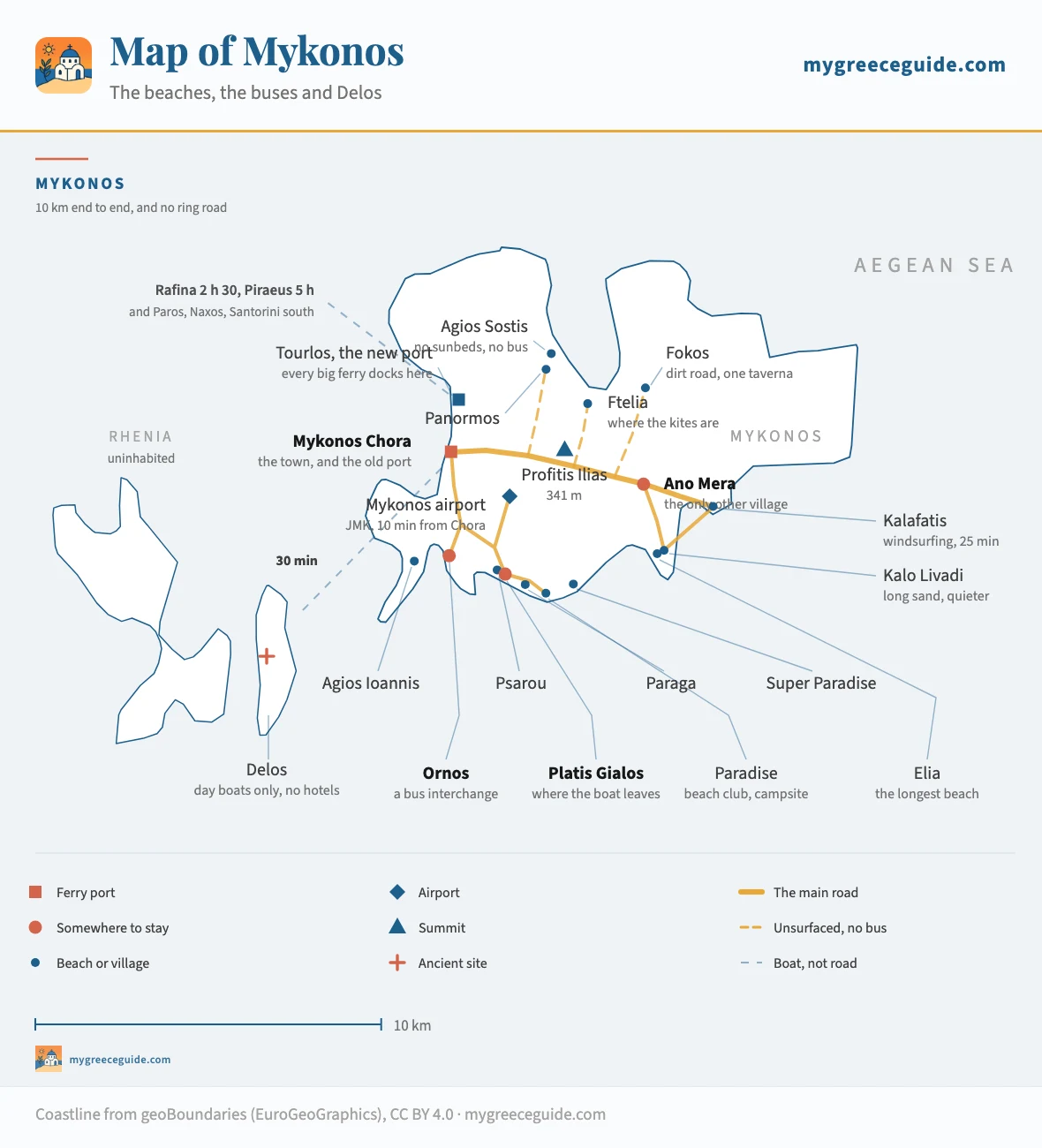
Mykonos is 10 kilometres across and arranged around one road. The south coast holds the organised beaches and the buses, the east is reached by changing at Ano Mera, and the north has no bus service of any kind. Delos sits a kilometre and a half off the west coast and the boat to it leaves from a different quay than the ferries. Every point on the map below is at its real coordinates.
The thing to fix first is that there is no coastal ring road. That is what separates Mykonos from Paros and Naxos. Beaches that look adjacent are joined by going back inland, or by boat.
The island
The beaches, sorted by what they are actually like
Mykonos has roughly twenty five beaches worth the name and the guides list them by geography, which is the least useful way to do it. The distance between two of them is rarely the problem. The gap that ruins a day is the one between a beach with a sound system and a beach with nothing on it, and those two can be fifteen minutes apart.
So the list below runs on that axis instead, from the loudest to the emptiest, with how you actually reach each one alongside. That second column is not decoration: on this island the access decides more than the sand does.
The rule under each name is how developed the beach is, from a stub for the ones with nothing on them at all to the full length for sunbeds, a bar and a sound system. The list runs from the loudest to the emptiest, so you can stop reading at the point that sounds like your holiday.
Sound systems, sunbeds and a bill
All of these are on the south coast, all of them are twenty minutes from the Chora, and the music starts in the afternoon.
- ParadiseBus from Fabrika, or the beach boat
- The one the island's reputation was built on. A campsite sits behind it and a club holds each end, the sound starts around three and the sand has vanished under sunbeds well before that. Nobody arrives here by accident.
- Super ParadiseSummer bus, or the beach boat
- The same proposition over the headland, in a bay you cannot see from the road until you are down in it. The hill in is steep enough that the taxi fare surprises people, and it runs later than Paradise does.
- PsarouTen minutes on foot from Platis Gialos
- No bus comes here, which tells you most of it. This is the beach that put Mykonos on the rich list, the yachts anchor a hundred metres off, and a pair of sunbeds costs more than a night's room in half the Cyclades.
- ParagaBus from Fabrika
- Two coves side by side and they are not the same beach. One has a club on it, the other has a campsite and a taverna and people reading. It is the half-step for anyone who wants Paradise within walking distance rather than underfoot.
- Platis GialosBus from Fabrika
- Hotels come down to the sand along its whole length and the beach boat leaves from the far end, so it works as the practical base of the south coast. Organised end to end, but the crowd is families rather than sound systems.
Organised, and you can still hear yourself
Sunbeds and a taverna, no soundtrack. Four of the five are on a bus route, and the two eastern ones need a change at Ano Mera.
- OrnosBus from Fabrika
- A shallow sheltered bay with a village wrapped round it, and the interchange every south-western bus passes through. Staying here means you can reach three other beaches without going back into town.
- Agios IoannisBus from Fabrika
- Small, and it faces due west at Delos, which makes it the sunset beach on an island where most of the sand faces the wrong way. Shirley Valentine was filmed here and the tavernas have not stopped mentioning it.
- EliaBus from Fabrika, change at Ano Mera
- The longest single stretch of sand on Mykonos. Sunbeds fill the middle third and both ends stay open, which is a rarer combination here than it sounds.
- Kalo LivadiBus, change at Ano Mera
- Long, flat and far enough east that the day crowd thins out before it arrives. Two or three tavernas at the back that people drive over for in the evening.
- KalafatisBus, change at Ano Mera
- The windsurfing bay. The meltemi comes down the Aegean from the north and hits this coast square on through the summer, so the schools are here and the swimming is choppy on exactly the afternoons that look perfect inland.
Nothing there, and that is the whole point
The north coast, plus one cove in the west. No bus reaches any of them, the last stretch of road is unsurfaced on two, and that is what has kept them.
- FteliaCar or scooter
- Wide, shallow and open to the north, which means wind. On a meltemi day the water is full of kites and nobody is swimming. On a still day it is one of the emptiest big beaches on the island.
- PanormosCar or scooter
- The bay that takes the whole north of the island. One organised stretch with sunbeds and a bar at its head, and open sand either side of it that you can walk to in five minutes and have to yourself.
- KapariCar, then a short walk down
- A small cove tucked round the headland from Agios Ioannis, facing the same sunset over Delos with a fraction of the people. There is nothing on it, so bring water.
- Agios SostisCar, then a dirt track
- No sunbeds, no bar, no bus, no shade. Kiki's Tavern stands on the slope above it with no electricity, no telephone and no bookings, and the wait for a table is the price of the best lunch on Mykonos.
- FokosCar, then unsurfaced road
- Further round the north coast, at the end of a track that most hire cars are technically not insured for. One taverna, and after that nothing at all in any direction. The road is what keeps it this way.
The bus network, and the two stations nobody warns you about
Mykonos has a genuinely good bus service for a Greek island of its size, and a trap sitting right at the front of it. There are two bus stations in the Chora, they are eight hundred metres apart, and they do not serve the same half of the island. Fabrika is at the southern end of town near the windmills and it runs the south coast, Ano Mera, the eastern beaches and the airport. The Old Port station is at the northern end and it runs the new ferry port and the north-east. Standing at the wrong one waiting for a bus to Paradise is the standard first morning on Mykonos. The airport line lands you at Fabrika, which is why arriving at Mykonos airport and heading east means crossing the town on foot before you catch anything.
The second thing the diagram shows is that this is an interchange network, not a set of direct lines. Ornos is where the south-west sorts itself out and Ano Mera is where the east does. Almost nothing runs beach to beach.
Two stations, two interchanges
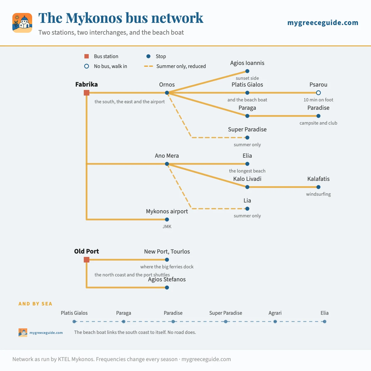
The beach boat is the part most visitors miss entirely. A small caique runs from the far end of Platis Gialos along the south coast to Paraga, Paradise, Super Paradise, Agrari and Elia, and back. By road those beaches are a series of separate spurs off the main spine. By sea they are one line, twenty minutes end to end, and you can start the day at one and finish it at another without going near the Chora.
The Chora, and where the two stations actually are
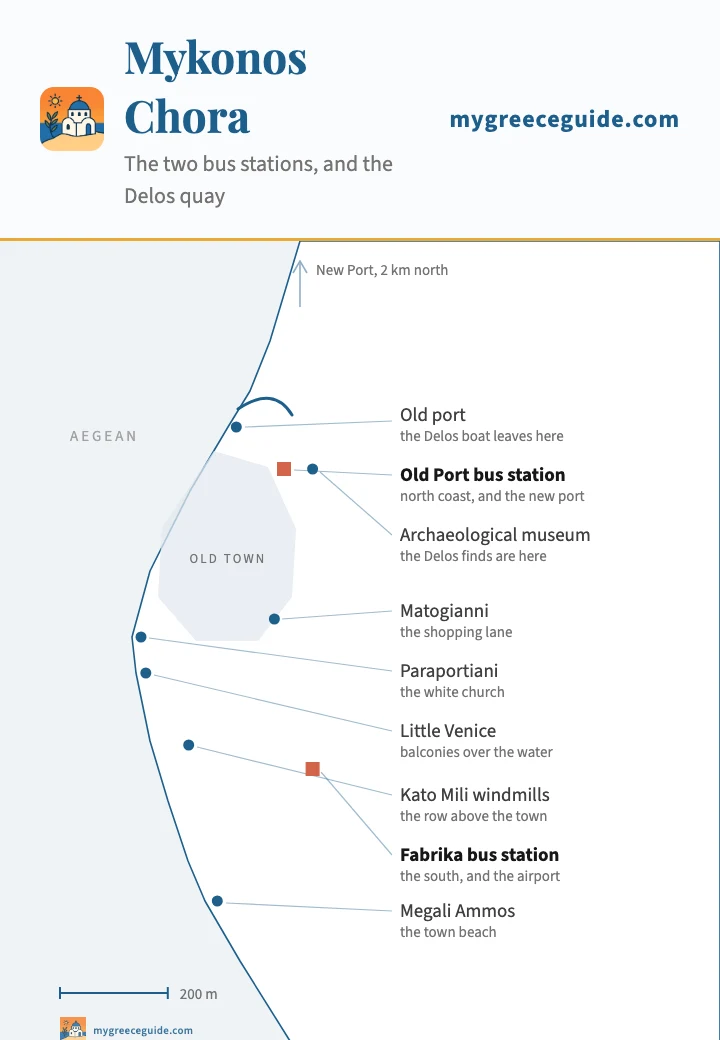
Mykonos town is eight hundred metres from end to end and about three hundred across, so everything in it is walkable, and the old town is closed to cars anyway. What the plan below is really for is the relationship between four points: the old port where the Delos boat leaves, the two bus stations at opposite ends, and the beach at the bottom. Which of those you end up walking to every day is decided when you book, and what a room costs in each area of the island follows the same geography.
The town, at 800 m end to end
Positions are real, the shoreline is drawn schematically. The two bus stations sit at opposite ends of the same short town. That is what this plan is here for. Note also that the big ferries do not come in at the old port on this plan: they dock at Tourlos, two kilometres north, and the shuttle to it leaves from the Old Port station.
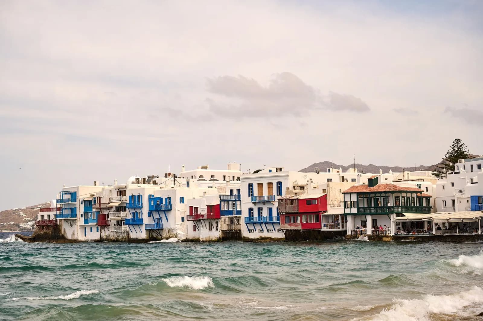
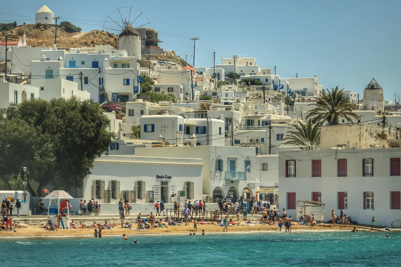
The old town between them is a deliberate maze. The lanes were laid out to confuse pirates and they still work, which is worth knowing before you agree to meet someone somewhere in it. Little Venice is the row of houses built with their balconies straight over the water on the west side, the Kato Mili windmills stand on the rise just south of it, and the two together are what every photograph of Mykonos is of. Matogianni is the lane the shops are on. Panagia Paraportiani, the white church that looks melted, sits by the water at the entrance to the Kastro quarter.
The town from the water
How long everything actually takes
Nothing on Mykonos is far, so the interesting column is not the distance. It is what happens to these numbers in August, and the note under the table is where that shows.
| From | To | Distance | Time | Worth knowing |
|---|---|---|---|---|
| The south coast, where the buses go | ||||
| Mykonos Chora | Ornos | 2.5 km | 7 min | The first bay south, and the interchange the other south-western buses run through |
| Mykonos Chora | Mykonos airport | 4 km | 10 min | JMK sits in the middle of the island, not out on a cape. The shortest airport run in the Cyclades |
| Mykonos Chora | Platis Gialos | 4 km | 10 min | Where the beach boat leaves from, which matters more than the beach itself |
| Mykonos Chora | Agios Ioannis | 4.5 km | 12 min | The west-facing one. Worth the drive at the end of the day rather than the middle |
| Mykonos Chora | Psarou | 4.5 km | 12 min | By road only, or ten minutes on foot from Platis Gialos. No bus goes in |
| Mykonos Chora | Paraga | 5.5 km | 15 min | Two coves and a campsite between Platis Gialos and Paradise |
| Mykonos Chora | Paradise | 6 km | 15 min | Fifteen minutes by road, ten by boat from Platis Gialos, and the boat has the better arrival |
| Mykonos Chora | Super Paradise | 7 km | 20 min | The last stretch drops steeply into the bay. Taxis charge for it |
| East, over Ano Mera | ||||
| Mykonos Chora | Ano Mera | 8 km | 15 min | The only other village on the island, and where every eastern bus changes |
| Mykonos Chora | Elia | 11 km | 25 min | The longest beach on Mykonos, over the middle and down the far side |
| Mykonos Chora | Kalo Livadi | 12 km | 25 min | Long, flat, and past the point where the day crowd gives up |
| Mykonos Chora | Kalafatis | 13 km | 25 min | The windsurfing bay on the east coast, straight into the meltemi |
| Mykonos Chora | Lia | 14 km | 30 min | The far south-east corner. Clear water, and the last beach with a road to it |
| North, where the surface runs out | ||||
| Mykonos Chora | Tourlos, the new port | 2 km | 5 min | Every ferry of any size docks here, not at the old port in town |
| Mykonos Chora | Agios Stefanos | 4 km | 10 min | A small resort beach just past the new port, and on a bus route |
| Mykonos Chora | Panormos | 6.5 km | 15 min | The north bay. Surfaced the whole way, and no bus on it |
| Mykonos Chora | Agios Sostis | 7.5 km | 20 min | The last few hundred metres are a dirt track, and there is nowhere to park at lunchtime |
| Mykonos Chora | Ftelia | 8 km | 20 min | Wide and open to the north. The kite bay when the meltemi is up |
| Mykonos Chora | Fokos | 11 km | 30 min | Unsurfaced for the last stretch. Most hire agreements quietly exclude it |
| By boat, and from two different quays | ||||
| Old port, in town | Delos | the ancient site | about 30 min | Day boats only, nowhere to sleep on the island, and it closes one day a week |
| Platis Gialos | the south beaches | beach boat | 10 to 25 min | Paraga, Paradise, Super Paradise, Agrari and Elia, in that order along the coast |
| New port, Tourlos | Rafina | Athens | 2 h 15 to 2 h 45 | The fast boats, and Rafina is an hour east of central Athens by bus |
| New port, Tourlos | Piraeus | Athens | about 5 h | The conventional ships, usually calling somewhere else on the way |
| New port, Tourlos | Paros | Cyclades | about 1 h | The easiest second island from here, and the junction for everything else |
| New port, Tourlos | Naxos | Cyclades | 1 h to 1 h 15 | Bigger, greener and a good deal cheaper to sleep on |
| New port, Tourlos | Santorini | Cyclades | 2 h to 3 h | High-speed boats. The pairing most people fly in and out for |
Every road figure here is for an ordinary day outside July and August, and on Mykonos that caveat does more work than it does anywhere else in the Cyclades. Nothing on this table is far. What goes wrong in August is the single road south out of the Chora, the queue at the Ornos junction and the fact that the car park at Paradise fills before noon, so a fifteen minute drive becomes forty and ends with nowhere to leave the car. Sailing times come from the operators and the frequencies change every season.
The row that changes plans is Platis Gialos to Elia. Eleven kilometres apart on the same coast, and by road it is twenty five minutes inland, over the middle and down the far side, because no road follows the shore between them. On the beach boat it is about twenty minutes and you never leave the sea.
Delos, half an hour off the west coast
Delos is the reason this map has a second island on it. It is a kilometre and a half from the Mykonos shore, it was the sacred centre of the Aegean for the best part of a thousand years, and in the Hellenistic period the town on it held something in the order of twenty five thousand people on an island you can cross in half an hour on foot. It has been a UNESCO World Heritage site since 1990. Today nobody lives on it except the site guards.
The practical points are all constraints. The boat leaves from the old port in the middle of the Chora, not from Tourlos where you arrived. There is nowhere to stay and no way to remain overnight, so the visit is bounded by the return sailing at both ends. The site closes one day a week and which day it is has moved between seasons, so it is worth checking rather than assuming. And it is bare: no trees, no shade among the ruins, and a marble surface that reflects the afternoon back at you.
The north coast, and where the tarmac stops
Everything above deals with the half of Mykonos that has a bus. The northern half is a different island and it stays that way for one reason: the roads. Panormos and Ftelia are surfaced the whole way and simply have no service on them. Agios Sostis and Fokos are reached by tracks that turn to dirt for the last stretch, and most hire agreements exclude unsurfaced roads, which is a clause worth reading before you decide the north is the plan.
What you get for the trouble is the opposite of the south coast: no sunbeds, and nobody collecting for the car park. The north also takes the meltemi head on through July and August, so the same wind that makes Ftelia a kite beach can make the water at Fokos genuinely rough on an afternoon that looks calm from the Chora.
Bus, boat or car
The honest answer depends on which of the three Mykonoses you came for. For the south coast, the bus is genuinely enough and it saves you the worst problem on the island. That problem is not driving, it is parking. The car park at Paradise fills before noon in August and the ones at Platis Gialos and Elia are not much better.
For the north, there is no alternative to a vehicle. For the Chora, a car is a liability: the old town is pedestrian, the streets around it are narrow and one-way, and you will pay to leave it somewhere. The pattern that works for most people is no car for the first few days, then two or three days of hire for the north and the far east.
Arriving, and where you go next
Ferries dock at Tourlos, the new port two kilometres north of town, and this catches people out because the old port is the one on all the photographs. From Athens the split is between Rafina and Piraeus, and it matters more than the crossing does: most of the fast boats leave from Rafina, which is an hour east of central Athens with no rail link, so the choice of port decides what time you have to get up.
Going on, Mykonos is well placed. Paros is about an hour and connects to everything, Naxos is a little over that, and the run down to Santorini takes two to three hours on a high-speed boat. If you are still deciding which islands to string together, how the Cyclades connect to each other is the thing to look at before the individual island guides.
Questions people ask about the map of Mykonos
Where is Mykonos on the map of Greece?
In the northern Cyclades, in the middle of the Aegean, about 150 kilometres south-east of Athens. Tinos is directly north across a narrow strait, Naxos and Paros are south, Syros is west, and Delos sits a kilometre and a half off the west coast with Rhenia behind it. The ferry from Rafina takes between two and a quarter and two and three quarter hours, the one from Piraeus around five, and the airport takes direct summer flights from most of Europe.
How big is Mykonos, and can you drive round it?
It is 85 square kilometres and about 10 kilometres across, so nothing on the island is more than half an hour from anywhere else. What you cannot do is drive round it, and that is the difference between Mykonos and Paros. There is no coastal ring road here. One road runs from the Chora across the middle to Ano Mera and on towards Kalafatis, everything else hangs off it as a spur, and the north coast is reached by separate tracks that do not join up. Going from one beach to the next usually means coming back inland first.
Can you get around Mykonos without a car?
For the south coast, yes, and better than most Greek islands. The catch is that the buses leave from two different stations in the Chora about eight hundred metres apart. Fabrika, at the southern end near the windmills, covers the south coast, Ano Mera and the airport. The Old Port station covers the new ferry port and the north-east. Ornos and Ano Mera are the two places you change. The north coast is the part no bus reaches at all, so Agios Sostis, Fokos and Panormos need a car, a scooter or a taxi.
Which part of Mykonos is best to stay in?
The Chora if the evening is the point, because it is the only place where you walk home. Ornos or Platis Gialos if you want to swim before breakfast and still reach town on a bus, and Ornos has the better bus connections of the two. Ano Mera if the bill matters more than the beach, since it is inland, half the price and fifteen minutes from both coasts. Agios Ioannis if you want the sunset over Delos from your own balcony. Paradise and Super Paradise are not places to sleep unless you intend to be awake.
How do you get from Mykonos to Delos?
By organised day boat from the old port in the middle of the Chora, not from the new port at Tourlos where the ferries dock, and the crossing is about half an hour. There is no accommodation on Delos and no way to stay the night, so the whole visit is built round the return sailing. The site closes one day a week and the day has moved between seasons, so check it before you plan a trip round it. Take water and a hat: the island is bare, there is almost no shade among the ruins, and the last boat back is early afternoon on some timetables.
Which beach on Mykonos is the quiet one?
The north coast, and the reason it is quiet is that no bus goes there and the last stretch of road to two of them is unsurfaced. Agios Sostis has no sunbeds, no bar and no shade, with Kiki's Tavern on the slope above it running without electricity or bookings. Fokos is further round the same coast at the end of a dirt road and has one taverna and nothing else. Kapari, a small cove near Agios Ioannis in the west, faces the same sunset as its famous neighbour with a fraction of the people on it.
Is Mykonos or Santorini better?
They sell different things and the map shows it. Santorini is one view, a drowned volcano with villages balanced on the rim, and the beaches are an afterthought made of black grit. Mykonos has no view of that kind and about twenty five beaches of real sand instead, plus an old town you can walk at night and an archaeological site half an hour offshore. If the trip is a photograph, Santorini. If it is swimming and evenings, Mykonos. They are two to three hours apart by fast boat, which is why so many people do both.
