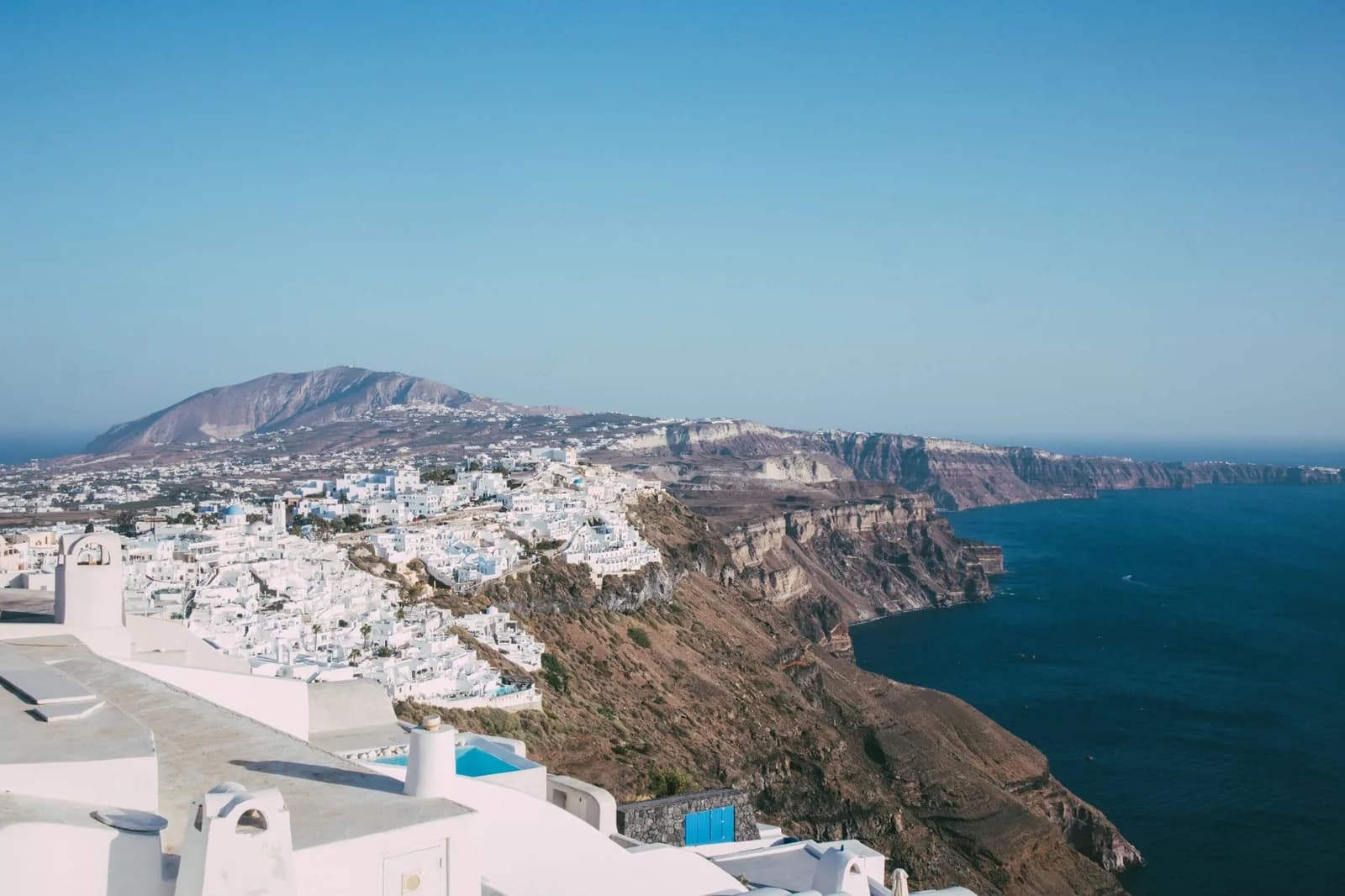
Santorini map: the caldera side and the beach side
Santorini is not a round island. It is the rim of a drowned crater, and which side of that rim you sleep on decides your view, your beach and most of your bill.
Look at any map of Santorini, Greece and the shape gives the island away. A crescent curves around a bay that is far too round to be natural, with a black islet sitting in the middle of it and a second island closing the ring to the west. That bay is a crater. Everything on this page follows from it.
The island
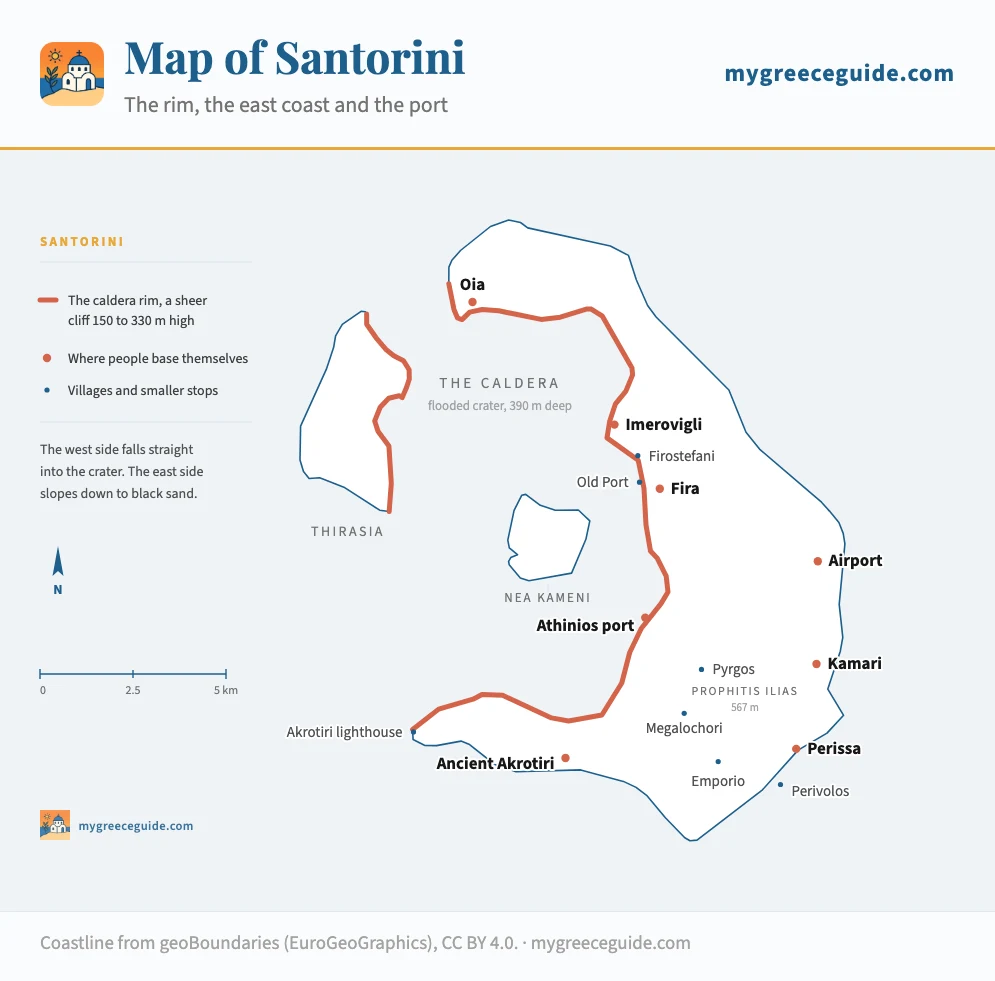
The whole island fits in 18 km north to south and never gets wider than 6 km. Oia is at the top of the crescent, Fira at the middle of its inner edge, and the long black beaches of Kamari and Perissa are down the outside where the land finally reaches the water. Nea Kameni, the dark lump in the middle of the bay, is the volcano itself, still growing.
The caldera side and the east coast
This is the only decision on Santorini that is hard to undo once booked. The two sides of the island are fifteen minutes apart by car and belong to different holidays at different prices. What separates them is the ground itself.
The gap in price is wider than the gap in distance. A rim terrace in Oia or Imerovigli runs at roughly three times what the same room fetches in Kamari or Perissa in the same July week, and the cheapest way to sleep on the caldera is to drop one village along the path rather than to drop a star rating. We compare where to sleep on each side of the rim if you want the numbers before you commit to one.
Pick a side and see what it costs you
Which side should you sleep on?
Four villages hang off the cliff in a row: Fira, Firostefani, Imerovigli and Oia. They share one view, one footpath and one price level.
What you get
- The crater and the sunset from your own terrace, without going anywhere
- The four villages linked by a cliff path you can walk end to end
- Boats to the volcano and the hot springs leave from the Old Port, directly below Fira
- Everything the island is famous for is within twenty minutes
What it costs you
- Roughly three times the room rate of the east coast for the same floor area
- Steps instead of streets, and no lifts: bags get carried, in Oia sometimes by mule
- No walkable beach. Ammoudi below Oia is a swim off a rock platform, not sand
- Oia between seven and nine in the evening is a crowd, not a village
Fira
The cheapest way onto the rim
The busiest of the four, and the one with buses, banks and a cable car.
Firostefani
A little above Fira
Ten minutes on foot from Fira, same view, half the noise.
Imerovigli
Well above Fira
Highest point of the rim at 330 m, quietest, furthest from anything open late.
Oia
The most expensive address on the island
The postcard, and the reason the postcard costs what it does.
Rates are the going rate for a double in July, checked across the usual booking sites. May and October run at roughly half of that on both sides of the island.
Why one side is a cliff and the other is a beach
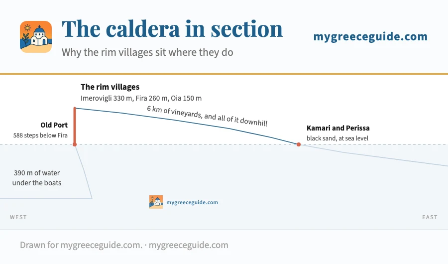
Around 1600 BC the volcano that stood here emptied itself and collapsed into the hole it had left. The sea poured in. What survived is the outer wall of the mountain, sliced open on the inside, which is why the west coast is a raw face of lava and pumice and the east coast is the gentle outer flank of a cone. The rim villages are built on the cut edge, and the vineyards are on the slope behind them.
West to east, in section
This is also why the sunset is such an industry here. The rim faces west across open water with nothing in the way, and a few thousand people crowd the same corner of Oia every evening. Imerovigli and Firostefani face the same sun from the same rim, ten minutes down the path, with a fraction of the crowd.
How long everything actually takes
Santorini is small enough that visitors assume distances are trivial, then lose an hour to a road built for donkeys. These are times outside July and August, when the Fira to Oia stretch and the port road both seize up. Two arrival points sit on opposite coasts and are easy to mix up: the runway is over at Monolithos on the east side, a flat 15 minute run into Fira, while the ferry quay is under the cliff on the west.
| From | To | Distance | Time | Worth knowing |
|---|---|---|---|---|
| Airport | Fira | 6 km | 15 min | Bus a few times an hour, or a short taxi ride |
| Airport | Oia | 18 km | 30 to 40 min | No direct bus, so it is a taxi or a booked transfer. Longer as the sunset traffic builds |
| Athinios port | Fira | 8 km | 20 min | Add half an hour when a big ferry unloads |
| Athinios port | Oia | 19 km | 40 min | The transfer everyone underestimates |
| Athinios port | Perissa | 15 km | 30 min | Hairpins out of the port, then flat and quick |
| Fira | Oia | 11 km | 25 min | Bus every 30 min in summer, full by six in the evening |
| Fira | Imerovigli | 3 km | 8 min | 35 min on foot along the caldera path, and worth it |
| Fira | Old Port | 588 steps | 20 min | No road down: cable car, the steps, or a mule |
| Fira | Kamari | 8 km | 15 min | Frequent buses, last one back around eleven |
| Fira | Perissa | 12 km | 20 min | Around the shoulder of Mesa Vouno, not over it |
| Fira | Ancient Akrotiri | 13 km | 25 min | Buses run, but only a handful a day |
| Oia | Perissa | 24 km | 45 min | End to end, and a change of bus in Fira |
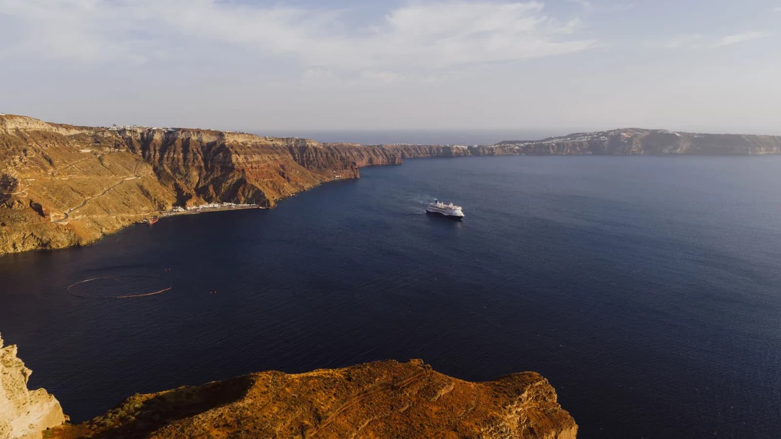
Athinios deserves its own warning. The ferry port is a concrete shelf at the bottom of the cliff with one road out, and that road climbs the wall in switchbacks wide enough for a bus if nothing is coming the other way. When a large ferry unloads, several hundred cars, a dozen coaches and every hotel transfer on the island try to use it at once. Twenty minutes to Fira becomes fifty, and the taxi rank has around thirty cars for the whole island. Arrange the pickup before you sail.
The one road out
Car, bus, or neither
Every route on the island passes through Fira, including the buses, which run from the station behind the main square out to Oia, Kamari, Perissa, Akrotiri and the port. In summer the frequent ones go every half hour and the rest a handful of times a day, which covers a beach holiday but not an evening in a hill village.
A car is genuinely optional here in a way it is not on Crete or Rhodes. If you are on the rim, walking and the bus will cover most of a week, and parking in Oia is close to impossible: the village is pedestrian, the two car parks fill by ten in the morning, and in August people abandon cars along the main road half a kilometre out. If you are on the east coast and want the wineries, Ancient Akrotiri and the lighthouse in the same trip, hire one for two days rather than seven.
The islands in the middle of the map
Three pieces of land sit inside the ring. Nea Kameni is the active cone, a black cinder heap whose summit crater is a 30 minute walk up from the landing stage, with no shade and no handrail. Palea Kameni, smaller and older, has the hot springs, which are a patch of warm rust-coloured water you swim into from the boat. Thirasia, the long island closing the west of the caldera, is the other half of the rim, cut off when the crater collapsed, and it has around 300 residents and one village on the cliff.
Inside the ring
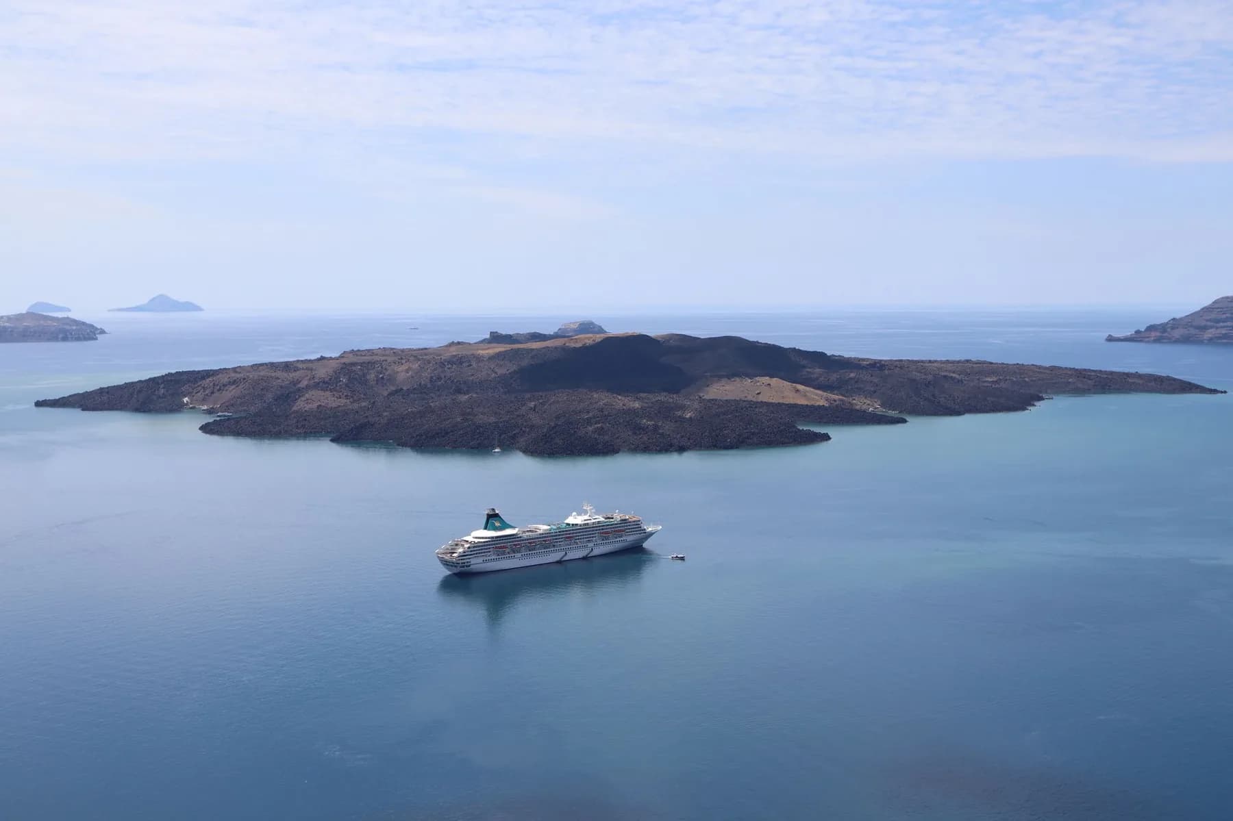
Boats to all three leave from the Old Port below Fira and from Ammoudi below Oia. The standard afternoon run does the volcano, the springs and Thirasia, then holds position in the middle of the caldera for the sunset, which is the one place on the island where you see the whole rim lit at once.
Where Santorini is, and why it is also called Thira
On a map of Greece, Santorini sits at the southern edge of the Cyclades, roughly 200 km south-east of Athens and 120 km north of Crete. Ios and Naxos are the islands above it, and below it there is nothing but open water until the Cretan coast. The rest of the group runs north from here, which is what makes the island a starting point as often as a destination. The flight from Athens takes 45 minutes, the fast ferry about 5 hours, the conventional one closer to 8.
That position also explains the three ways most people arrive by sea. The long one is the boat down from Piraeus, which is the cheap overnight option or the expensive fast one depending on which hull you book. The short one is the two hour run south from Mykonos, almost entirely on high-speed catamarans that feel every swell. And the crossing up from Heraklion is the one to treat with suspicion, because it is a single exposed leg across open water and is the first sailing on the board to be cancelled when the meltemi blows. To see how the Cyclades sit against the Dodecanese and the Ionian, the groups are laid out side by side here.
The second name causes more confusion than it should. Thira is the official Greek name, which is why the airport code is JTR and why road signs and ferry boards say Thira rather than Santorini. Santorini came later, from the Venetians, after Santa Irini. And the capital village is Fira, the same word worn down in local speech. Thira the island, Fira the town, Santorini the label on the postcard, one crescent of rock.
Questions people ask about the map of Santorini
Which is the nicest part of Santorini?
The four rim villages, if what you came for is the caldera. Oia is the postcard and the most crowded, Imerovigli sits highest on the cliff at around 300 m with the same sunset and a fraction of the crowd, Firostefani is Fira with the noise turned down, and Fira itself is the one place with shops, buses and a nightlife. None of them has a beach. If you want sand, the nicest part is the east coast at Kamari or Perissa, where the black volcanic beaches are, and where the same room costs roughly a third of what the rim charges in the same week.
Can you just walk around Santorini?
You can walk the rim, and it is the best thing to do here on foot: the cliff path from Fira through Firostefani and Imerovigli to Oia is about 10 km and takes 3 to 4 hours, with no shade after the first hour. Within any single village, walking is the only realistic way to get about. What you cannot do is walk the island. It is 18 km end to end, there is no coastal path down either shore, and the caldera side is a cliff, so getting from Fira to Perissa means a bus or a car whatever your intentions were.
What country is Santorini in?
Greece. The island sits in the southern Aegean at the bottom of the Cyclades, about 200 km south-east of Athens and 120 km north of Crete, and its official Greek name is Thira, which is why the airport code is JTR and why ferry boards rarely say Santorini at all. Flights from Athens take 45 minutes, the fast ferry about 5 hours and the conventional ferry closer to 8.
Should you wear white in Santorini?
There is no rule, no dress code and nobody local expects it. The habit comes from photographs: the villages are whitewashed with blue domes, so white and blue clothing reads as camouflage and pastels or bright colours stand out against it, which is why so many photo shoots choose one or the other. The practical advice is different and matters more. The rim is a staircase of volcanic stone, so wear shoes with grip rather than sandals, and expect anything pale to pick up dust on the paths above Oia.
Where is Santorini airport on the map?
On the flat east side of the island near Monolithos, between Kamari and Messaria, about 6 km from Fira and 20 km from Oia. It has a single runway that ends at the beach, which is why the approach comes in low over the water. Reckon on 10 to 15 minutes by car to Fira, 30 to 35 to Oia, and note that the airport is nowhere near the ferry port: Athinios is on the opposite coast at the foot of the caldera cliff.
