Kos airport is at Antimachia, not in Kos Town
KGS sits in the middle of the island, 24 km from the capital and ten minutes from Kardamena. Which resort you booked decides whether the transfer is a formality or half an hour of the island road.
Kos International Airport "Hippocrates", code KGS, is the way almost every visitor reaches the island, and the one thing worth knowing before you book is where it stands. Rhodes and Corfu put their airports within a few kilometres of their capitals. Kos put its own inland at Antimachia, on the flat middle of the island, which leaves some resorts ten minutes from arrivals and others a half hour away.
Where Kos airport actually is
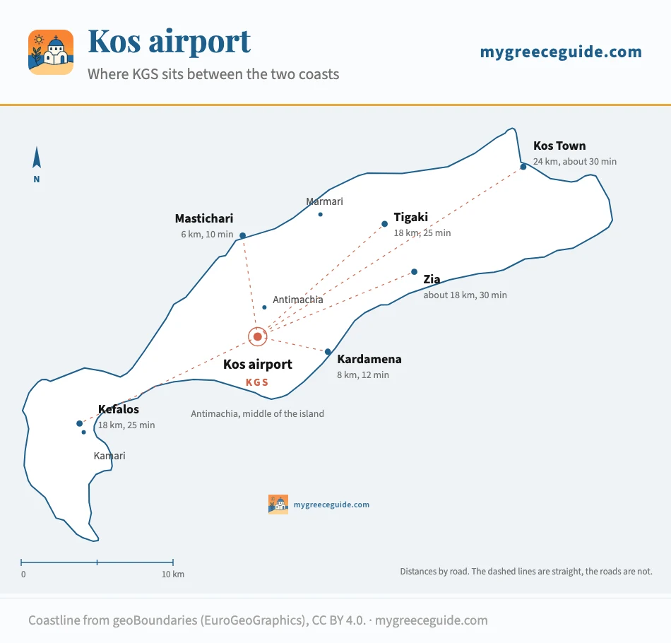
Kos is a ribbon 45 km long, with Kos Town and the ferry harbour at the north-eastern end and the Kefalos headland trailing away to the south-west. The runway lies across the waist of it, on the plateau behind Kardamena, about 4 km from either coast. An airport in the middle of a long island is close to everything and next to nothing, which is exactly the position KGS is in: no resort is more than half an hour away, and no resort is walking distance either.
Position
How long the transfer takes, by car and by bus
One main road runs the length of Kos and the airport road joins it a couple of kilometres north of the terminal. Everything below assumes that road outside its worst hours.
| From KGS to | By road | Driving | On the bus |
|---|---|---|---|
| Mastichari | 6 km | 10 min | Seasonal KTEL run, a handful a day, plus the Kalymnos ferry connection |
| Kardamena | 8 km | 12 min | Seasonal KTEL run down to the coast, roughly 20 min |
| Tigaki and Marmari | 18 km | 25 min | No direct service. Change in Kos Town, then the frequent coast bus |
| Kefalos and Kamari | 18 km | 25 min | Seasonal KTEL run west, and the last departures are early |
| Zia | About 18 km | 30 min, the last part uphill | No bus that works with luggage. Taxi or hire car |
| Kos Town | 24 km | 30 min | KTEL airport coach, roughly 40 min, loosely timed on arrivals |
| Kos Town ferry port, for Bodrum | 25 km | 35 min | Airport coach to the KTEL station, then ten minutes on foot |
The bus is a genuine option for Kos Town and a gamble everywhere else. KTEL Kos meets arrivals with a coach into the capital, and for two people with hand luggage it costs a small fraction of the taxi. The runs west to Kardamena, Mastichari and Kefalos are seasonal, thinner, and finish earlier in the evening than a delayed charter tends to land.
Frequencies and fares both move with the season and the timetable is reissued twice a year, so treat any figure you find online, this page included, as an order of magnitude and confirm with the operator before you count on it. Taxis wait outside arrivals and run on a zone system rather than a meter for airport journeys; ask what the fare to your resort is before the bags go in the boot.
Your resort decides what the transfer looks like
The transfer you care about runs from the terminal to one specific hotel. Pick the place you have booked and the half hour of island road stops being an abstraction.
Where are you staying on Kos
West of the terminal
East of the terminal
Kardamena
South coast, straight down from the runway
- Driving
- 12 min
- Bus
- Seasonal run to the front
Most of the charter traffic on your flight is going here, which is why the coach queue outside arrivals looks alarming and then clears in twenty minutes. You will be in your room before anyone heading for Kos Town has left the airport road.
If you are still weighing up where to stay rather than how to reach it, seeing the resorts laid out along the coast makes the distances between them concrete, and adds the cycling times, which matter more here than on any other Greek island of this size. The Kos hotels guide then picks the hotels in each resort.
A charter airport, with a British accent
KGS handles somewhere over two million passengers in a year and does almost all of it between May and October. The mix is heavily package and charter, and heavily British, with German, Dutch and Scandinavian operators behind them. This shapes the day rather than the year: the traffic arrives in waves rather than in a steady stream, because package weeks start and end on the same days.
In practice that means Saturday, and to a lesser extent Sunday and Monday, in the middle of the summer. Several wide arrivals land inside the same hour, the same aircraft turn round and leave full, and one modest terminal handles both movements at once. Seating in departures runs out, the queue for security backs up past the check-in desks, and the hire car returns are busy at exactly the same time. Allow three hours for a Saturday departure in August and ninety minutes for a Tuesday in May, and you will have judged both correctly.
Half an hour east of the terminal
What happens to the flights out of season
The European network that fills the terminal in August is seasonal in the strict sense: it stops. From roughly November to March the direct routes from northern Europe disappear from the board and what remains is the domestic link to Athens plus a thin Dodecanese service. Out of season, Kos is an Athens connection rather than a destination you fly to, and the connection times are set by the domestic schedule rather than by your convenience.
None of that matters for a July holiday and all of it matters for a shoulder-season trip booked on the assumption that the summer timetable is the timetable. Check the actual dates rather than the route map, especially either side of the changeover in late October and late March, when a route can be listed and not yet flying.
Rhodes is the fallback worth knowing when the Kos board empties. It is the group's other door, a couple of hours away by fast boat in season, and it holds its European routes for several weeks longer at each end of the year. The shape of that island is the catch: RHO sits at the northern tip, Lindos is an hour down the east coast, and the transfer is nothing like the short hop from KGS to Kardamena. If the flights push you that way, work out which of its resorts suits the trip before booking, because Ixia, Faliraki and Lindos are three different holidays on one island.
Hiring a car at KGS
A car is more optional on Kos than on most Greek islands, because the eastern third has real bike lanes and the bus along the north coast is usable. It is far from optional if you are staying at Kefalos, at Zia, or anywhere you would rather not reach by a seasonal coach with an early last departure. The desks sit in a single row in the small arrivals hall, and they are all working the same handful of flights, so the wait after a Saturday wave is longer than the size of the building suggests.
Booking before you fly is worth more here than the price difference implies. Kos has a small fleet compared with Crete or Rhodes, automatics are a minority of it, and walk-up rates in August reflect that. Two or three days is the usual pattern rather than a full week, which is the booking the international chains price worst.
The other way in: Bodrum, 4 km across the water
Kos sits about 4 km off the Turkish coast at its north-eastern tip, and Bodrum harbour is a twenty minute ferry from Kos Town. Bodrum airport is larger than KGS, keeps a longer season, and is served by routes that never touch Kos. For a trip outside the summer window, flying into Turkey and crossing by boat is sometimes the only same-day option that does not involve Athens.
The catch is that the crossing is an international border, with passports, a ferry timetable that changes with the season, and a transfer from Bodrum airport to the harbour on top. It suits a flexible traveller and punishes a tight connection. In the other direction, a day in Bodrum is one of the easiest excursions in the Aegean, which is why the boats run several times a day all summer. The rest of them sit in our guide to the Greek airports.
Hippocrates, and the names on the sign
The full name is Kos International Airport "Hippocrates", after the physician born on the island around 460 BC, whose plane tree still stands in the square below the castle in Kos Town. The airport turns up in searches under four or five different names, Kos Island International, Hippocrates Airport, Antimachia after the village next to it, and plain KGS on your boarding pass. They all point at the same single terminal in the middle of the island.
Questions people ask about Kos airport
Which airport do you fly into for Kos?
Kos has one airport, KGS, at Antimachia in the middle of the island, and every flight to the island lands there. It is roughly 24 km from Kos Town at the north-eastern end and only ten to fifteen minutes from Kardamena and the western resorts, which is the fact most listings leave out. The only alternative is not on Kos at all: Bodrum in Turkey is a short ferry from Kos Town harbour, keeps a longer season, and is worth pricing for a trip outside the summer window.
How early should you arrive at Kos airport?
It depends far more on the day than on the month. Kos is a package island, so the charter flights bunch on Saturdays and to a lesser extent Sundays and Mondays, and several aircraft turn round inside the same hour. Three hours for a Saturday departure in July or August is right, and ninety minutes for a Tuesday in May is plenty. Drop the hire car before you join any queue rather than after, because the returns are busy at exactly the same moment as check-in.
Why is Kos airport blurred on satellite maps?
Because the airfield has a military side. Greece restricts aerial and satellite imagery of sites with a defence function, and several Greek airports are pixelated or low-resolution on mapping services for that reason rather than because anything is being hidden from visitors. It has no effect on the civil terminal, which you can photograph like any other. If you want to see where the runway actually sits on the island, use a road map rather than the satellite layer.
What is the name of Kos airport?
Kos International Airport "Hippocrates", after the physician born on the island around 460 BC. The IATA code is KGS and the ICAO code LGKO. You will see it written Kos Island International Airport, Hippocrates Airport or simply Antimachia on older signage and in some timetables. They are all the same airport.
Is there anything to eat or buy at Kos airport?
Enough for a wait, not enough for a long one. There is a duty free shop, a couple of cafes and snack counters, a newsagent and some gift stands, most of it past security in a fairly small airside area. On a busy summer changeover day the seating around it goes first and the queues at the counters are long, so eat at the hotel before the transfer rather than planning on lunch at the airport. Out of season much of it is quiet or shut between flights.
Where can I see Kos airport arrivals and departures?
The airport operator publishes a live board online and the same feed drives the screens in the terminal, so that is the version to trust when a flight slips. Tour operators also show the status of their own charter flights in their apps, which is usually the quickest way to check a package flight. Search by flight number rather than by destination, because on a Saturday several aircraft go to the same handful of northern European cities within an hour of each other.
