Peloponnese map: the loop from Athens, and what is on it
An hour west of Athens the motorway crosses a canal and the country changes. Almost everything people picture as ancient Greece is on the far side of it, and unlike the islands you reach all of it by road.
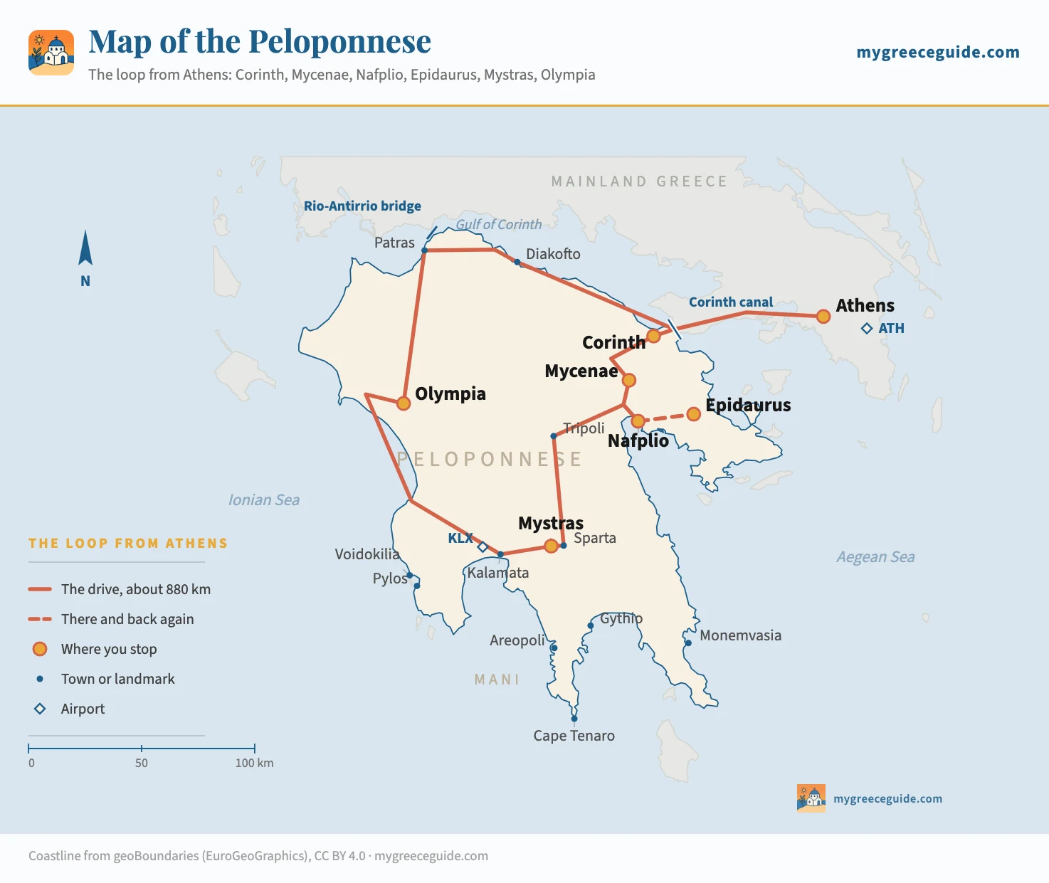
Every other map of the Peloponnese scatters pins across a peninsula and leaves you to work out what connects them. The thing that connects them is a road, and it is the only region of Greece where that sentence is true. The map below draws the drive: 880 km from Athens back to Athens, through Corinth, Mycenae, Nafplio, Epidaurus, Mystras and Olympia, with the places it misses marked small so you can see what a longer trip would buy you.
The drive
The loop, stage by stage
Seven legs, anticlockwise, starting and finishing in Athens. Distances are road distances and the times are driving times with no stops in them. Nothing here is longer than three and three quarter hours at the wheel, and only two legs pass two hours.
Stage 1
Athens to Corinth
84 km
1 h driving
A8, toll
The dullest leg and the one that surprises people, because it is motorway the whole way and it ends at a canal 25 m wide with a 90 m drop to the water. Stop on the old road bridge for the view along it, then carry on 8 km to Ancient Corinth, where the temple of Apollo has stood since the sixth century BC and the Acrocorinth fortress rises 575 m behind it. An hour and a half covers both. Corinth is not a place to sleep, it is a place to stop on the way in.
Stage 2
Corinth to Mycenae
45 km
40 min driving
A7, then 5 km of local road
You leave the coast and the landscape turns to olive terraces and low bare hills. Mycenae is the oldest thing on the loop by a long way: the citadel was at its height around 1350 BC, a thousand years before the Parthenon, and the Lion Gate is the oldest monumental sculpture in Europe still standing where it was put. The site is small and takes an hour and a half with the beehive tomb below it. There is no shade on the hill, so this one is worth doing early.
Stage 3
Mycenae to Nafplio
25 km
25 min driving
Local road through Argos
The shortest leg of the loop, and the one that changes the trip. Nafplio was the first capital of independent Greece, it has Venetian bastions on three sides and a fortress up a staircase everyone calls 999 steps, and it is the only place on the peninsula that works as a base rather than a stop. Two nights here reaches Mycenae, Epidaurus and Ancient Corinth without moving hotel again. Most people who drive the loop in a week sleep here twice.
Stage 4
Nafplio to Epidaurus
30 km each way
30 min driving
Coast road east
The one detour on the loop, and the only stop where the thing you came for is still in use. The theatre seats 14,000, it was built around 340 BC, and its acoustics are not a story: a coin dropped on the orchestra floor is audible from the top row, and people test it all day. The Athens and Epidaurus Festival still stages Greek tragedy here in July and August, which is worth timing a trip around. Two hours on site, then back the way you came.
Stage 5
Nafplio to Mystras
130 km
2 h driving
A7 to Tripoli, then national road
The longest inland leg, climbing over the Arcadian plateau at around 700 m and dropping into the Evrotas valley. Mystras is the surprise of the loop: a Byzantine city on the slope of Mount Taygetos, abandoned in the 1830s, with churches still holding their frescoes and a palace under restoration. It is steep, it takes three hours to do properly, and it is the last capital of the Byzantine world rather than a classical site. Ancient Sparta is 6 km away and there is almost nothing left of it, which tells you something about Sparta.
Stage 6
Mystras to Olympia
200 km
3 h driving
Over Taygetos, then the coast road
The hardest driving on the loop and the best of it. The Langada pass crosses Taygetos at 1,300 m in a sequence of switchbacks, drops into Kalamata, and then the road runs up the west coast through Kyparissia with the Ionian on your left the whole way. Olympia at the end of it held the games every four years from 776 BC to AD 393; the stadium, the workshop where Phidias built the statue of Zeus, and the museum with the Hermes of Praxiteles need half a day. Sleep in modern Olympia or push on.
Stage 7
Olympia to Athens
335 km
3 h 45 driving
Patras, then the A8
North to Patras, then east along the Gulf of Corinth on a motorway that runs between the mountains and the water for 200 km. It is the fastest leg and the one worth breaking: Diakofto, halfway along, is the bottom station of a rack railway that climbs 22 km up the Vouraikos gorge to Kalavryta, an hour each way on a narrow-gauge line built in 1896. Add the round trip and the last day becomes a day rather than a transfer.
Around 880 km with the Epidaurus detour in it, and a shade under twelve hours at the wheel before a single stop. Spread over seven days that is well under two hours of driving a day, which is why this loop works and why the same seven days spent island hopping would put you on four boats. Tolls on the A7 and the A8 come to roughly €30 for the round trip, paid in cash or by card at barriers you cannot avoid, and fuel adds about €70 in a small petrol car.
How far everything is from Athens
This is the table the search results for this region do not have, and it settles most of the planning arguments on its own. Everything below is measured from central Athens unless the group heading says otherwise.
| Destination | Distance | Driving | What it gets you |
|---|---|---|---|
| On the loop, from central Athens | |||
| Corinth canal | 84 km | 1 h | Motorway the whole way. Close enough that people do it as a half day and go home |
| Nemea | 110 km | 1 h 20 | The wine country of the Argolid, and a stadium nobody queues for |
| Mycenae | 120 km | 1 h 30 | Doable as a day trip from Athens, and much better as the second stop of a week |
| Epidaurus | 130 km | 1 h 45 | The theatre. Coach parties arrive from Athens mid-morning and leave by three |
| Nafplio | 145 km | 1 h 50 | The base the whole eastern half of the loop is built around |
| Patras | 215 km | 2 h 15 | The ferry port for Italy, and the northern corner of the loop |
| Sparta and Mystras | 220 km | 2 h 40 | Over the Arcadian plateau. The last half hour climbs and the view opens with it |
| Kalamata | 235 km | 2 h 30 | Further than Sparta and quicker, because the A7 runs to the door |
| Olympia | 290 km | 3 h 20 | The far corner. Going and returning in a day is 7 hours of driving for 3 hours on site |
| Off the loop, and each worth an extra day | |||
| Diakofto | 180 km | 1 h 50 | Bottom station of the rack railway up the Vouraikos gorge, on the way home from Patras |
| Kalavryta | 200 km | 2 h 20 | Or an hour from Diakofto on the train, which is the entire point of going |
| Pylos and Voidokilia | 300 km | 3 h 45 | The best beach in the Peloponnese and a Frankish castle above it, on the west coast |
| Areopoli, in the Mani | 320 km | 4 h | Tower houses and bare stone. The middle finger of the peninsula, and a different country |
| Monemvasia | 330 km | 4 h 15 | A Byzantine town on a rock joined to the shore by a causeway. No cars inside it |
| Cape Tenaro | 365 km | 4 h 45 | The southern tip of mainland Greece, and the last 40 km of it take an hour |
| The two ways in that are not Athens | |||
| Kalamata town, from KLX | 10 km | 15 min | Seasonal flights from several European cities, and almost empty in winter |
| Mystras, from KLX | 68 km | 1 h 15 | Over the Langada pass at 1,300 m. Beautiful, slow, and not a night drive |
| Areopoli, from KLX | 85 km | 1 h 30 | The coast road through Kardamyli and Stoupa, which is the drive people remember |
| Olympia, from KLX | 150 km | 2 h | Up the west coast. This pairing makes a five-day trip work without touching Athens |
| Olympia, from Patras | 120 km | 1 h 30 | The move if you arrive on the ferry from Bari, Brindisi or Ancona |
Read the two number columns against each other rather than either on its own. Kalamata is 90 km further from Athens than Nafplio and only 40 minutes further, because the A7 runs there in a straight line. Cape Tenaro is 45 km past Areopoli and costs another 45 minutes, because the road down the Mani is single track with a village every few kilometres. That gap between distance and time is the whole argument for basing yourself in two places on this peninsula instead of five.
Where the Peloponnese actually is
South-west of Athens, hanging off the bottom of the Greek mainland, and shaped like a hand with four fingers pointing into the sea. It covers about 21,500 square kilometres, a little more than Wales, and roughly a million people live on it. The Gulf of Corinth runs along its northern edge and separates it from central Greece for 130 km; at the eastern end that gulf closes to a 6 km neck of land, the isthmus, which is the only place the peninsula ever touched the rest of the country.
It has been an island since 1893, when the Corinth canal was finally cut through that neck after two thousand years of people trying. Nero started it in AD 67 with six thousand Jewish prisoners and gave up; before and after him, ships were dragged overland on a paved slipway called the Diolkos. The canal that exists is 6.4 km long, 25 m wide at the water and cut 90 m deep through solid rock, which makes it spectacular to look down into and almost useless to modern shipping. Nothing wider than a small cruise ship fits, and it has been closed for landslip repairs more than once in recent years.
None of which matters when you are driving. Several bridges cross the canal, including the motorway, and the two at each end submerge into the water to let boats through rather than lifting. There is a second road in as well, further west: the Rio-Antirrio bridge, a 2.9 km cable-stayed crossing opened in 2004, which links Patras to the mainland north and is the route you take if you are coming down from Delphi or Meteora rather than out of Athens.
The middle of the peninsula is the part the map explains best. It is mountain: Ziria and Chelmos in the north both pass 2,300 m, Menalo in Arcadia reaches 1,981 m, and Taygetos in the south is the high point of the whole peninsula at 2,404 m. The roads go around all of it rather than through it, which is why the loop is a ring and not a star. It also explains why the four fingers feel like separate countries: getting from the Mani to Messenia means going up and over, and the people who live on them have never had much reason to.
The six places the loop is built around
Ancient Corinth is the one people skip and the one that sets up the rest. It was the richest city in Greece because it controlled the isthmus and charged for it, and Saint Paul spent eighteen months preaching in it. Seven columns of the temple of Apollo are still standing, and the Acrocorinth above is a fortress the Greeks, Romans, Byzantines, Franks, Venetians and Ottomans each rebuilt in turn. An hour and a half, and the car park is at the gate.
Mycenae is a thousand years older than anything else on the loop. This was the centre of the civilisation that the Iliad remembers, at its height around 1350 BC and burnt by 1100 BC, and Schliemann dug the gold death masks out of the grave circle inside the walls in 1876. The Lion Gate at the entrance is the oldest monumental sculpture in Europe still standing where it was raised. Allow ninety minutes with the Treasury of Atreus down the hill, and go before eleven, because the citadel is a bare rock with no shade.
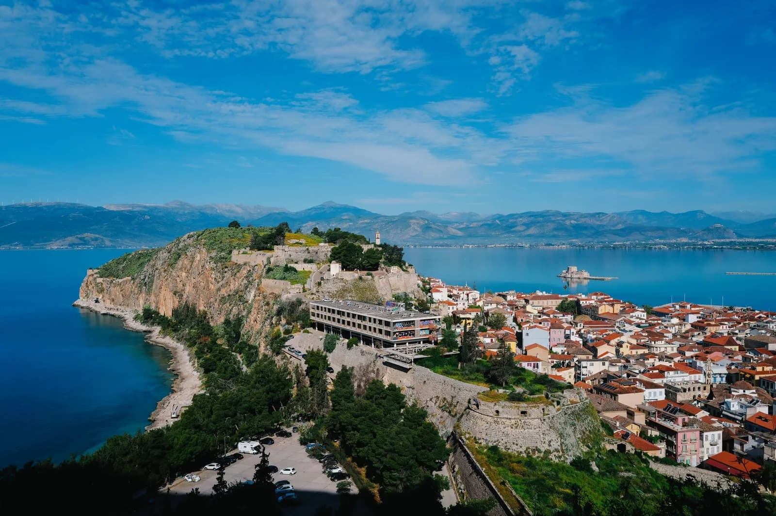
Nafplio is not a site, it is the base, and it is the reason the eastern half of this trip is comfortable. Venetian and Ottoman in turn, capital of the new Greek state from 1829 to 1834, with marble streets, a fortress reached by a staircase everyone calls 999 steps and nobody has ever counted at more than about 850 and a small castle on an islet in the middle of the bay. Everything in the Argolid is inside an hour of it. Two nights here beats one night each in three different towns, and it is the only place on the loop with a proper choice of what you get for the money in Greece.
Epidaurus is thirty minutes east of Nafplio and holds the best preserved theatre in the Greek world. It was built into the hillside around 340 BC, it seats 14,000, and the acoustics work so precisely that a whisper on the orchestra floor carries to the back row. The sanctuary of Asclepius around it was a healing centre, which is what the theatre was there to serve. Two hours, and if your dates fall in July or August, check the Athens and Epidaurus Festival before booking anything else.
Mystras is the one nobody expects. A Byzantine city built up the flank of Mount Taygetos from 1249, capital of the Despotate of the Morea, and the last significant Byzantine centre to fall to the Ottomans in 1460. It was lived in until the 1830s, when the new state built Sparta on the plain below and everyone moved down, so what stands is a town rather than a ruin: churches with their frescoes intact, a palace, monasteries still occupied by nuns. It is steep and it takes three hours. Ancient Sparta, 6 km away, is almost nothing, which is the joke history played on the Spartans.
Olympia is the far corner of the loop and the reason to go the long way round. The games were held here every four years from 776 BC until a Christian emperor banned them in AD 393, and the site is a valley of pines and fallen columns with the stadium still marked out at the end of it. The museum next door has the Hermes of Praxiteles and the pediments from the temple of Zeus, and it is the better half of the visit. Half a day, and it is the only stop on the loop that does not work as a day trip from anywhere.
What the loop misses, and what each one costs you
The classic week stays on the archaeology and keeps to the north and the east. Everything in small blue on the map is the second trip, and three of them are strong enough to bend the first one.
The Mani costs two days and changes the character of the whole holiday. The middle finger of the peninsula is a spine of bare limestone with stone tower houses stacked in villages that fought each other into the twentieth century, and a road that runs down the west coast through Kardamyli and Stoupa before the trees give out entirely. Cape Tenaro at the bottom is the southernmost point of mainland Greece, and only Tarifa in Spain reaches further south on the European mainland. It had a temple to Poseidon that the ancients took for an entrance to the underworld. Add it between Mystras and Kalamata and it slots into the loop rather than extending it.
Monemvasia costs a day and a half and is the hardest one to fit, because it hangs off the south-east and nothing else is near it. A Byzantine town on the landward face of a 300 m rock, joined to the coast by a single causeway, with no cars allowed inside the walls and a gate you walk through into a street of stone houses and one main square. Stay the night rather than looking at it: the day visitors leave by six and the place is transformed.
Voidokilia and Pylos cost half a day if you are already going to Olympia, because they sit on the same west coast road. Voidokilia is a perfect semicircle of sand between two headlands with a lagoon behind it and a Frankish castle on the cliff above, and it is the best beach on the peninsula by a distance. Pylos below it is where the naval battle of Navarino was fought in 1827, which is a large part of the reason Greece is a country.
The Diakofto rack railway costs three hours and fits into the drive home. A narrow-gauge line built in 1896 climbs 22 km up the Vouraikos gorge from the coast to Kalavryta, on rack and pinion where the gradient passes one in seven, through tunnels cut in the rock face with the river directly below. It is an hour each way and the station is 200 m off the motorway.
Getting there, and why you end up driving
There are three ways onto the peninsula and two of them are Athens. Athens airport sits 33 km east of the city, on the wrong side of it for the Peloponnese, but the ring road takes you round without going through the centre and you are at the canal about an hour and a quarter after leaving the terminal. Kalamata airport in the south takes seasonal flights from a handful of European cities between May and October and is the smarter arrival if the Mani and Messenia are what you came for. Patras, in the north-west corner, takes the ferries from Bari, Brindisi, Ancona and Venice, which is how a good number of people arrive with a car already.
No ferry is involved in reaching the Peloponnese itself, which is worth saying because it is the single biggest difference between this region and the rest of Greece. Everything else worth seeing here involves a boat and a timetable, and a cancelled sailing costs you a day. Here the weather does not decide your itinerary and nothing sells out in August except hotel rooms.
Public transport gets you between towns and abandons you at the sites. KTEL buses run from the Kifissos terminal in Athens to Nafplio, Tripoli, Sparta, Kalamata and Patras several times a day, and the suburban railway runs along the north coast as far as Kiato and Aigio. What none of them do is cover the last five to thirty kilometres: Mycenae, Mystras, Epidaurus and Olympia all sit off the main roads, and reaching them without a car means a taxi from the nearest town or an organised tour. This is not a region where you can improvise on buses the way you can move around Athens on the metro.
How many days it actually takes
Three days covers the Argolid and nothing else, and it is a real trip rather than a compromise. Athens to Corinth and Mycenae on the first day, two nights in Nafplio, Epidaurus on the second morning, home on the third. About 350 km in total. You will not have seen Olympia or Mystras and you should not pretend otherwise.
Five days is the full loop with the corners cut. Same start, then Nafplio to Mystras on day three, Mystras to Olympia on day four over the Langada pass, and the long run home on day five. Two of those five days are three-hour drives and you arrive at Olympia in the afternoon rather than the morning, which matters in July. It works, and it is tighter than it looks on paper.
Seven days is the answer. Two nights in Nafplio, a night near Sparta or Kardamyli, a night in Olympia, and a spare day that you spend either on the Mani or on the rack railway depending on the weather. Every site gets the half day it needs, no day has more than two and a half hours of driving in it, and there is room for a long lunch in Kardamyli or Nafplio without anyone looking at the clock.
Ten days brings in Monemvasia and the bottom of the Mani properly, and it is also when adding an island starts to make sense, because Kythira sits off the south-east tip and Zakynthos is a short crossing from the west coast. Beyond that the peninsula does not really reward more time in one go, and the six island groups laid out across both Greek seas are a better use of a fortnight than a second week here.
One thing to get right whichever length you choose. The Peloponnese is at its best in April, May, September and October, and it is genuinely hard work in the middle of summer: Mycenae and Olympia are open sites with no shade, inland Arcadia and the Evrotas valley regularly pass 38 °C in July, and none of it is cooled by the sea breeze that makes the islands bearable. If you can only come in August, do the sites at opening and keep the driving for the middle of the day, when the car has air conditioning and the ruins do not.
Questions people ask about the Peloponnese
How many days do you need in the Peloponnese?
Five is the honest minimum for the loop and seven is the number that works. Three days reaches Corinth, Mycenae, Nafplio and Epidaurus and sends you home from the eastern quarter, which is a good trip but it is not the Peloponnese. Five gets you across to Mystras and Olympia at the cost of two long driving days back to back. Seven gives every site the half day it needs, two nights in Nafplio, a night in Olympia, and leaves an afternoon spare for the rack railway at Diakofto on the way home. Ten days is when the Mani and Monemvasia stop being a sacrifice.
Is the Peloponnese close to Athens?
Much closer than most people assume. The Corinth canal is 84 km from central Athens and takes an hour on the motorway, Mycenae is 1 h 30, and Nafplio is 1 h 50. The far corner, Olympia, is 3 h 20. Nothing on the peninsula is more than about four and a half hours from the capital, which is less than the ferry to Santorini on a good day. No boat is involved at any point and the airport is on the Athens side, so a hire car picked up on arrival is on the loop within the hour.
What is the nicest part of the Peloponnese?
It depends which of the four fingers you mean, and they are genuinely different places. The Argolid, in the north-east, is where the archaeology is stacked most tightly and where Nafplio sits, which is the prettiest town on the peninsula and the easiest base. The Mani, the middle finger in the south, is bare stone, tower houses and empty road, and it is the one people come back for. Messenia in the south-west has the beaches, Voidokilia above all, and the golf and hotel development around Costa Navarino. Arcadia in the middle is mountain, forest and stone villages, and almost nobody stops there.
Is the Peloponnese worth visiting?
If you want ancient Greece rather than the postcard of Greece, it is the part of the country to go to. Mycenae, Olympia, Epidaurus, Corinth, Mystras and Bassae are all on it, and four of them are on the same week's drive. What it does not have is the thing the islands sell: there is no caldera, no white village stacked above a blue sea, and hardly any of the nightlife. The trade is a landscape you drive through instead of sail past, hotels at maybe two thirds of Santorini prices, and sites you can be alone in at nine in the morning.
Which part of Greece is the Peloponnese, and is it an island?
It is the large peninsula hanging off the south of the mainland, immediately west and south-west of Athens, and it accounts for roughly a fifth of the country's land area. Technically it stopped being a peninsula in 1893, when the Corinth canal was cut through the 6 km isthmus that joined it to the rest of Greece, so it is an island by the strict reading. Practically it is not: the canal is 25 m wide, several bridges cross it including the motorway, and you drive over without noticing unless you stop to look.
Can you do the Peloponnese without a car?
Partly, and badly. KTEL buses run from Athens to Nafplio, Sparta, Kalamata, Patras and Tripoli, and the suburban railway reaches Kiato on the north coast, so the towns are all connected. The sites are not. Mycenae is 5 km off the main road, Epidaurus is 30 km from Nafplio across country, Mystras is 6 km up a hill from Sparta, and Olympia means changing at Pyrgos. Every one of those gaps is a taxi or an organised day tour. If you are not driving, base yourself in Nafplio, use it for Mycenae and Epidaurus by tour, and treat Olympia as a separate trip rather than part of a loop.
Is there a printable map of the Peloponnese?
The map on this page is an image file rather than an embedded Google map, so it saves and prints like a photograph and it opens on a phone with no signal, which describes a good deal of Arcadia and most of the Mani. It is drawn from real coordinates, so the distances on it are true and the scale bar works. What it is not is a road atlas: the loop is drawn as a corridor through the towns it actually passes, not as a turn by turn route, and you will still want offline maps on the phone for the last kilometre to a site.
