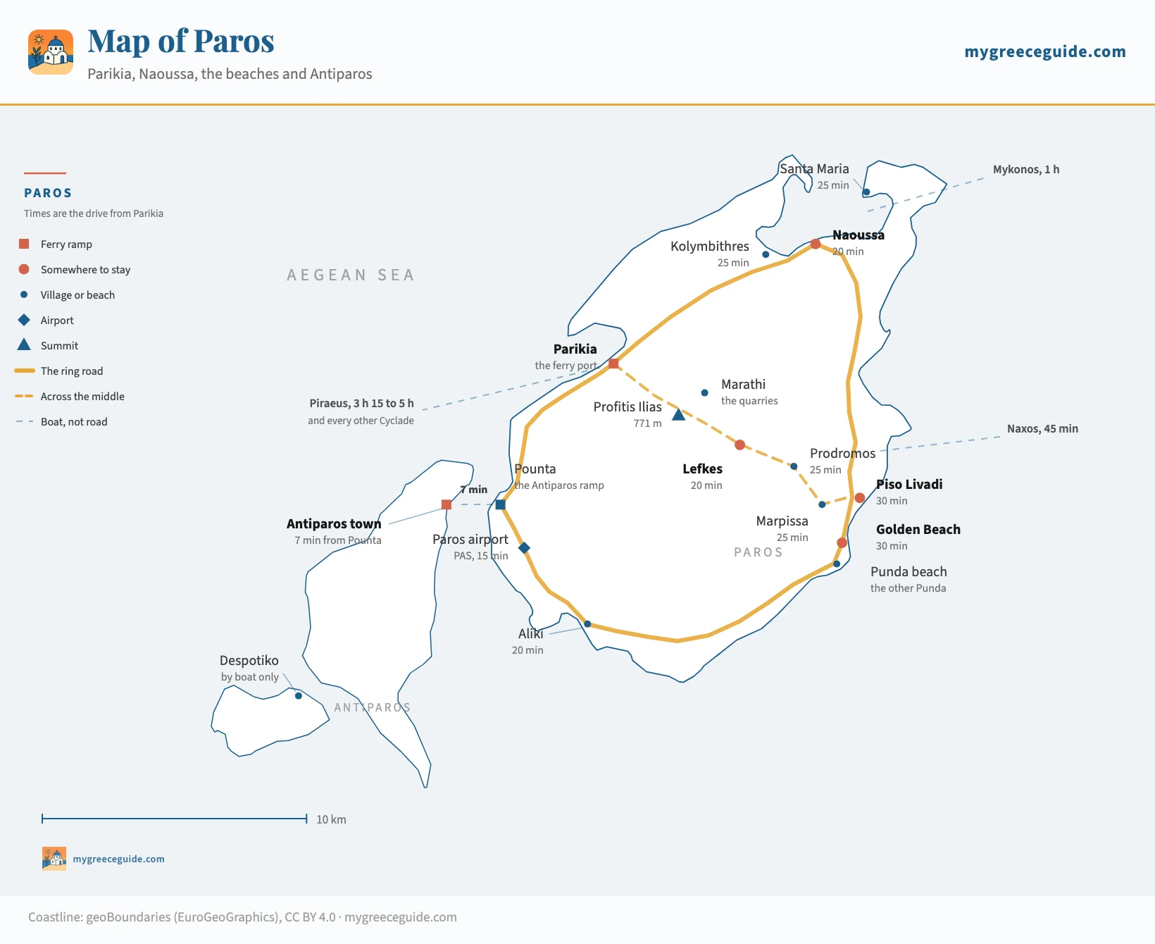
Paros map: where Parikia, Naoussa and the beaches are
Paros lands you at Parikia and almost nobody stays there. The town people actually book is 15 kilometres away on the other coast, the beaches are on a third side of the island, and a second island sits 7 minutes off the west shore. One map settles all of it.
Paros is arranged around four places, and the trip works or fails on which of them you book: Parikia the port, Naoussa on the north coast, the run of sand down the east side, and Antiparos across the strait. None of them is more than 35 minutes from any other. Every point on the map below is at its real coordinates, with the drive from Parikia under its name.
It is the third largest of the Cyclades and the one every ferry line touches, which is why so many people pass through it without deciding anything. Look at how the group connects and the reason becomes obvious.
The island
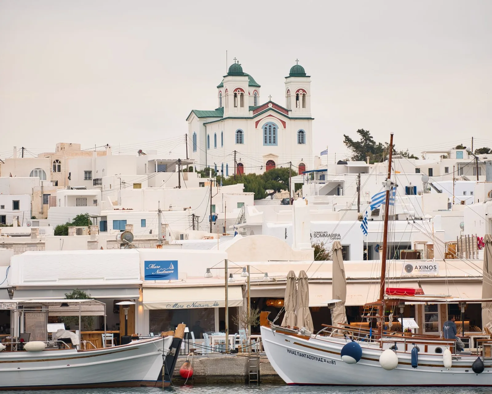
Parikia is where you land, Naoussa is where you sleep
The two towns are 15 kilometres and 20 minutes apart on the map and much further apart than that in practice, because they were built for different things. Parikia is a transport function that grew a town around it. The ferry ramp is on the seafront, the island bus station is beside it, the car hire desks are behind that, and the old town starts one street back. Everything about it is organised around people arriving and leaving, which is exactly what you want for a night either side of a boat and exactly what wears thin over a week.
Naoussa is a fishing harbour on the north coast that kept the harbour. The caiques still work out of it, the ruin of a Venetian mole sits half submerged across the entrance, and the tables of thirty tavernas come down to the water on three sides of a quay you can cross in ninety seconds. Behind it the lanes are narrow and whitewashed and full of shops that stay open until midnight. The beaches of the north coast, Kolymbithres and Santa Maria and the rest, are 10 minutes away.
What that costs is money and a car. Naoussa is the most expensive part of the island to sleep in and it has been getting more so for a decade, and it is 20 minutes from the ferry you came in on. Parikia is cheaper, better connected by bus and closer to the airport, and the split between the two shows up clearly in what a room costs.
The compromise most people miss is on the east coast. Piso Livadi is a smaller harbour with the same idea in it, 30 minutes from the port and 25 from Naoussa, and the sand at Golden Beach starts a few minutes south. Nobody arrives on Paros intending to stay there, which is most of the argument for it.
How long everything actually takes
Paros is small and the ring road is good, so nothing here is a real journey. The value of the table is in the pattern rather than in any one line: the island is a circle, and from Parikia you are never more than about 35 minutes from any point on it.
| From | To | Distance | Time | Worth knowing |
|---|---|---|---|---|
| The north, where most people end up sleeping | ||||
| Parikia | Livadia | 700 m | 10 min on foot | The town beach, north along the seafront. Shallow, and it fills with families by ten |
| Parikia | Naoussa | 15 km | 20 min | The drive that decides the trip. Buses run it every half hour or so through the summer |
| Parikia | Kolymbithres | 19 km | 25 min | Round the head of the bay past Naoussa. The granite is the reason people come |
| Parikia | Santa Maria | 21 km | 25 min | The north-east corner, and the sheltered end of it when the meltemi blows |
| Across the middle, and down the east coast | ||||
| Parikia | Marathi | 5 km | 10 min | The ancient marble quarries, signposted off the Lefkes road. Bring a torch |
| Parikia | Lefkes | 12 km | 20 min | The old capital, 300 m up. The cross-island road climbs to it and keeps going |
| Parikia | Prodromos | 16 km | 25 min | The far end of the Byzantine path down from Lefkes, walkable in about an hour |
| Parikia | Marpissa | 19 km | 25 min | A working village on the eastern slope, above the beaches rather than on them |
| Parikia | Piso Livadi | 22 km | 30 min | A small fishing harbour with tavernas round it. The quiet alternative to Naoussa |
| Parikia | Golden Beach | 23 km | 30 min | Chrissi Akti. Long, sandy, and where the windsurfing schools are |
| Parikia | Punda beach | 24 km | 35 min | The beach club on the EAST coast. Nothing to do with Pounta, the ferry ramp |
| Parikia | Drios | 26 km | 35 min | The south-east corner, past the sand. The ring road turns west from here |
| The south-west, and the crossing to Antiparos | ||||
| Parikia | Pounta | 10 km | 15 min | A ramp, a café and a car park. You do not stay here, you drive onto a boat |
| Parikia | Paros airport | 11 km | 15 min | PAS, on the flat behind Aliki. Propeller flights from Athens, and nothing after dusk |
| Parikia | Aliki | 13 km | 20 min | A fishing village on the south coast, five minutes from the runway and quieter than it sounds |
| Naoussa | Golden Beach | 20 km | 25 min | North coast to east coast, the run people underestimate when they book |
| The full ring | back to Parikia | about 70 km | half a day | Naoussa, the east coast, Aliki, Pounta and home. Paros is small enough to close the loop |
| By boat, from the quay at Parikia | ||||
| Pounta | Antiparos | 1.5 km | 7 min | The car ferry, roughly every half hour in season and less often out of it |
| Parikia | Antiparos town | Antiparos | about 30 min | A separate passenger boat, straight into the Chora. Summer only, and no cars |
| Parikia | Naxos | Cyclades | 30 to 45 min | Several a day all year. The most common second island from here |
| Parikia | Mykonos | Cyclades | 45 min to 1 h 15 | Depending on the boat. The reason a fly-in fly-out pair works from Mykonos airport |
| Parikia | Santorini | Cyclades | 2 h to 2 h 30 | High-speed. The conventional boats take longer and call at more islands on the way |
| Parikia | Piraeus | Athens | 3 h 15 to 5 h | Fast boat or conventional Blue Star. The slower one is steadier in a swell |
Road times are for an ordinary day outside July and August, at the pace these roads allow rather than the one a mapping app assumes. In the first fortnight of August the stretch between Parikia and Naoussa can take half as long again, and the car park at Kolymbithres is full by half past ten. Sailing times come from the operators, and the frequencies change every season.
The row that changes plans is Naoussa to Golden Beach. Twenty kilometres and 25 minutes, north coast to east coast, and it is the drive a week in Naoussa involves every time somebody wants the big sandy beach rather than the pretty rocky one. It is not far. It is just further than the booking photograph suggested.
Parikia, and what is actually in it
The ferry ramp comes down onto the middle of the seafront and the town is immediately behind it, which puts Paros in a small group of Cycladic islands where arriving does not involve a second journey. On Santorini the boats tie up at Athinios, a concrete shelf under the caldera with a hairpin road above it. Here you walk off the ramp, cross one road and you are in the market street.
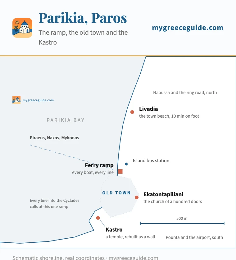
The port, at 1 km across
Everything on this plan is within about a kilometre of the ferry ramp. The Ekatontapiliani is one of the oldest churches still standing in Greece, sixth century and largely intact, and it is three minutes inland from the quay, which nobody expects of a ferry town. The Kastro at the south end is not a castle in the usual sense: the Venetians pulled down a marble temple and laid its columns on their sides to build the wall, and the drums are still visible in it.
What Parikia does not have is an evening. The waterfront is a road with traffic on it and the tavernas sit on the wrong side of that road, so the thing Naoussa does with its quay simply does not happen here. Livadia, the town beach, is 10 minutes north along the shore and is shallow and fine and busy by ten in the morning. For a night before a boat that is everything you need. For seven, it is not.
Naoussa, Kolymbithres and the north coast
Naoussa sits at the back of a deep bay that bites into the north of the island, and the bay is the reason the north works. It is sheltered from three sides, so the beaches round its edge stay swimmable when the meltemi has made the east coast unusable, and they are all within 10 minutes of the town. Kolymbithres is the one on the postcards: granite worn into smooth grey shapes with pockets of sand between them, across the water from Naoussa and reachable either by road round the head of the bay or by a small boat from the quay in about ten minutes.
The edge of the bay
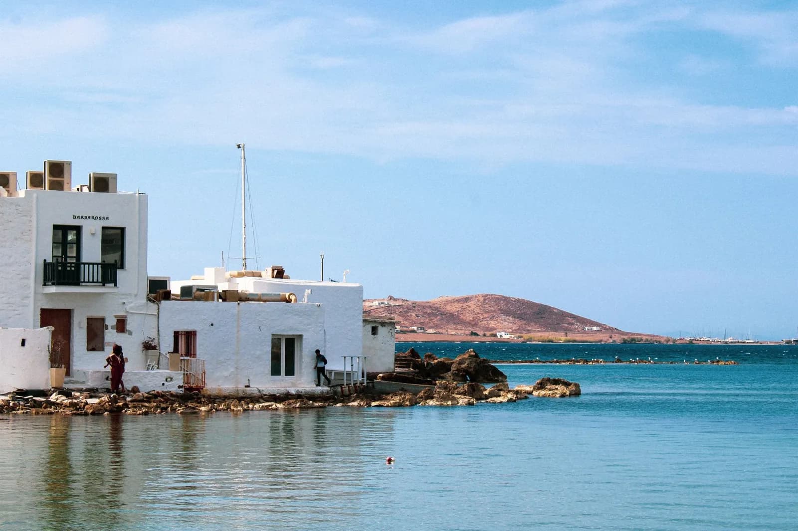
Santa Maria is the other end of the same bay, on the north-east corner, with a longer stretch of sand and a diving school on it. Monastiri sits under the headland next to Kolymbithres. All three are the same 20 to 25 minutes from Parikia and the same 10 from Naoussa, which is the whole case for the north as a base.
The east coast, the wind, and the two places called Punda
The long sand is on the east side, and so is the meltemi. Between June and September the wind comes down the Aegean from the north and hits this coast square on, which is why the windsurfing and kitesurfing schools are all here and why the water is choppy on the afternoons everyone else calls perfect. Golden Beach and New Golden Beach are the centre of it, about 30 minutes from Parikia, and the windsurfing world championship has been run off them. Piso Livadi, a few minutes north, is the harbour that serves the whole stretch.
Then there is the trap, and it catches people every summer. Pounta and Punda are two different places on opposite coasts of the island. Pounta, on the west, is the ferry ramp for Antiparos: a car park, a café and a boat. Punda Beach, on the east, is a beach club with a sound system, 35 minutes away by road. Booking a room near one when you meant the other is a 45 minute correction, and taxi drivers have heard it before.
Lefkes, and the marble under the island
One road cuts across the middle of Paros instead of round it, and it is worth the 20 minutes. Lefkes sits at 300 metres on the flank of Profitis Ilias, the 771 metre summit that fills the centre of the island, and it was the capital for as long as the pirates made living on the coast a bad idea. The lanes are paved in marble, the church of Agia Triada has two openwork bell towers that look nothing like the rest of the Cyclades, and the old Byzantine road still runs downhill from the village to Prodromos on flagstones you can walk in an hour.
The village, and the mountain it is on
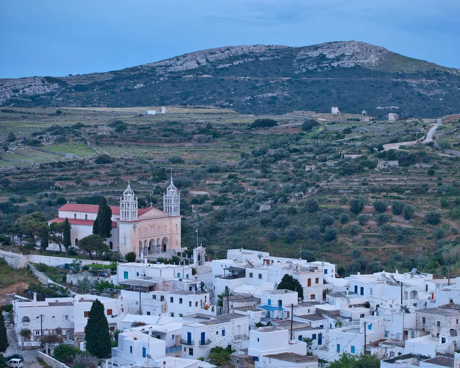
The marble is the reason any of this exists. The quarries at Marathi, 10 minutes out of Parikia on the same road, cut a stone so fine that light passes through it for a few centimetres, and the ancient world used it for the things it cared most about. The tunnels are open, unlit and unfenced, and they are one of the few sites in the Cyclades with nobody at the entrance selling a ticket. Bring a torch and reasonable shoes.
Antiparos, seven minutes off the west coast
Antiparos is close enough that the strait between the two islands is shallow enough to wade in places, and it is a genuinely different island. It is a fifth of the size and has one town. The pace is what Paros had thirty years ago, give or take the handful of expensive houses hidden along the west coast that nobody points out.
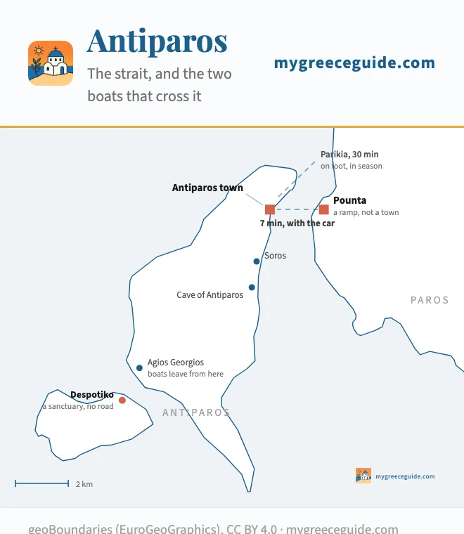
The strait, at 12 km across
This is the island map above, cropped: same coastline, same projection, same coordinates. Two boats cross here and they leave from different places, which is where the confusion starts. The car ferry runs from Pounta on Paros, takes 7 minutes and goes roughly every half hour in season. The passenger boat from Parikia takes about 30 minutes, runs in summer only and carries no vehicles. Coastline from geoBoundaries (EuroGeoGraphics), CC BY 4.0.
What is on it, in order of how far you have to go. Antiparos town is at the ramp, low and white with one long street through it and a Venetian castle in the middle. The cave is eight kilometres south, a chamber 100 metres down a concrete staircase, with names cut into the stalagmites going back centuries. Byron's is the one people go looking for. Soros and the beaches of the east coast are shallow and calm.
Despotiko is the one worth planning for. An uninhabited islet off the south-west corner with a sixth century BC sanctuary of Apollo on it, under excavation since 1997 and being reassembled column by column as the digging goes on. There is no road and no ferry: boats go from Agios Georgios on Antiparos in season, so reaching it is a day rather than an afternoon, and it is the quietest archaeological site in the Cyclades for exactly that reason.
Bus or car, and where the line falls
Paros has the best bus network in the Cyclades after Crete, and on an island with a ring road that matters. The Parikia to Naoussa service runs every half hour or so through the summer, the east coast route reaches Piso Livadi and Golden Beach several times a day, and Pounta, Aliki and Lefkes are all on the timetable. A week here without a car is genuinely workable, which is not true of Naxos or Milos.
Where it stops working is the fringe. The last bus back from the east coast goes earlier than dinner in Naoussa finishes, the connections between two points that are both away from Parikia usually route through Parikia, and Marathi, Kolymbithres and the small bays are a walk from the nearest stop. Two days of car hire out of seven covers all of it, and that is what most people on this island end up doing.
Getting here, and where Paros goes next
Parikia is one of the busiest quays in the Aegean and that is the practical argument for the island. From Piraeus it is three and a quarter hours on a fast boat and four to five on a conventional Blue Star, and the slower one is the steadier of the two when the meltemi is up. There is also a small airport in the south taking propeller flights from Athens, useful for a connection and awkward for luggage.
Naxos is 30 to 45 minutes east and it is the obvious pairing. The two face each other across a strait, boats run all year, and they are not the same trip: Naxos is more than twice the size with a thousand metre mountain in it, longer beaches and lower prices, while Paros has the harbour, the better dinner and the ferry connections. North, Mykonos is between 45 minutes and an hour and a quarter, which makes a fly-in fly-out pair straightforward. South, Ios and then Santorini, about two hours on a high-speed boat.
The reason to start or end a Cycladic route here rather than anywhere else is on the timetable rather than on the ground. Almost every line out of Athens calls at Parikia, so it is the island you can leave from in nearly any direction on nearly any day. Work out which islands actually connect to which before you fix the order, because the lines run west to east and a route that fights them costs days.
Questions people ask about Paros
Which part of Paros is best to stay?
Naoussa, unless a specific reason sends you elsewhere. It is a working fishing harbour on the north coast that grew a restaurant scene around itself, the beaches of the north are 10 minutes away, and the evening actually happens there. Parikia is the alternative and it is not the same product: it is the port, so every ferry in the Cyclades calls at it, which makes it the right base for one night at the start or the end of a trip and the wrong one for a week. The third answer is Piso Livadi on the east coast, half the size of Naoussa and half the bill, and the fourth is Golden Beach if you came to windsurf. All four are inside 35 minutes of each other.
Which town on Paros is considered the nicest?
Naoussa takes the vote, and it takes it on the harbour rather than on the town behind it. The old quay is small, the caiques still tie up on it, half a Venetian mole sits in the water at the entrance, and the tables go right down to the edge. Lefkes is the other candidate and it wins on a different measure: 300 metres up in the middle of the island, marble lanes, two bell towers on the church of Agia Triada and no sea view at all. Parikia has the oldest thing on the island, the sixth century church of the Ekatontapiliani, and the worst first impression, because you meet it at a ferry ramp.
What is special about Paros, Greece?
Two things the map shows and the brochures do not. The first is that Paros is the junction box of the Cyclades: nearly every line out of Piraeus calls at Parikia, so it is the island you can leave from, in almost any direction, on almost any day. The second is the marble. The quarries at Marathi produced the stone the Venus de Milo was cut from, the tunnels are still there and you can walk into them, and the same rock paves the lanes of Lefkes and holds up the walls of the Kastro in Parikia, where the columns of a temple were laid on their sides to build it.
Which island is better, Santorini or Paros?
They are not competing for the same week. Santorini sells one view from a caldera rim and prices it accordingly, and two nights is usually the honest answer. Paros is 196 square kilometres of island with a road round the outside, real beaches on the east coast, a mountain village in the middle and a second island 7 minutes off the west coast. If the trip is a photograph, Santorini. If it is a fortnight of swimming, driving and eating for roughly half the money, Paros, and the two are about two hours apart by fast boat if you want both.
How do you get from Paros to Antiparos?
Two boats, and they leave from different places, which is where people go wrong. The car ferry crosses from Pounta, a ramp on the west coast of Paros 15 minutes south of Parikia, and it takes 7 minutes and runs roughly every half hour in season. The other is a passenger boat straight from the quay at Parikia into Antiparos town, about 30 minutes, summer only, and no cars. If you have hired a car, drive to Pounta. If you have not, the Parikia boat saves you a bus.
Where is Paros on the map of Greece?
In the middle of the Cyclades, in the Aegean, about 165 kilometres south-east of Athens. Naxos is directly east across a strait, Antiparos is a kilometre and a half off its own west coast, Mykonos is north and Ios and then Santorini are south. Piraeus is between three and a quarter and five hours away depending on the boat, and there is a small airport in the south of the island taking propeller flights from Athens.
