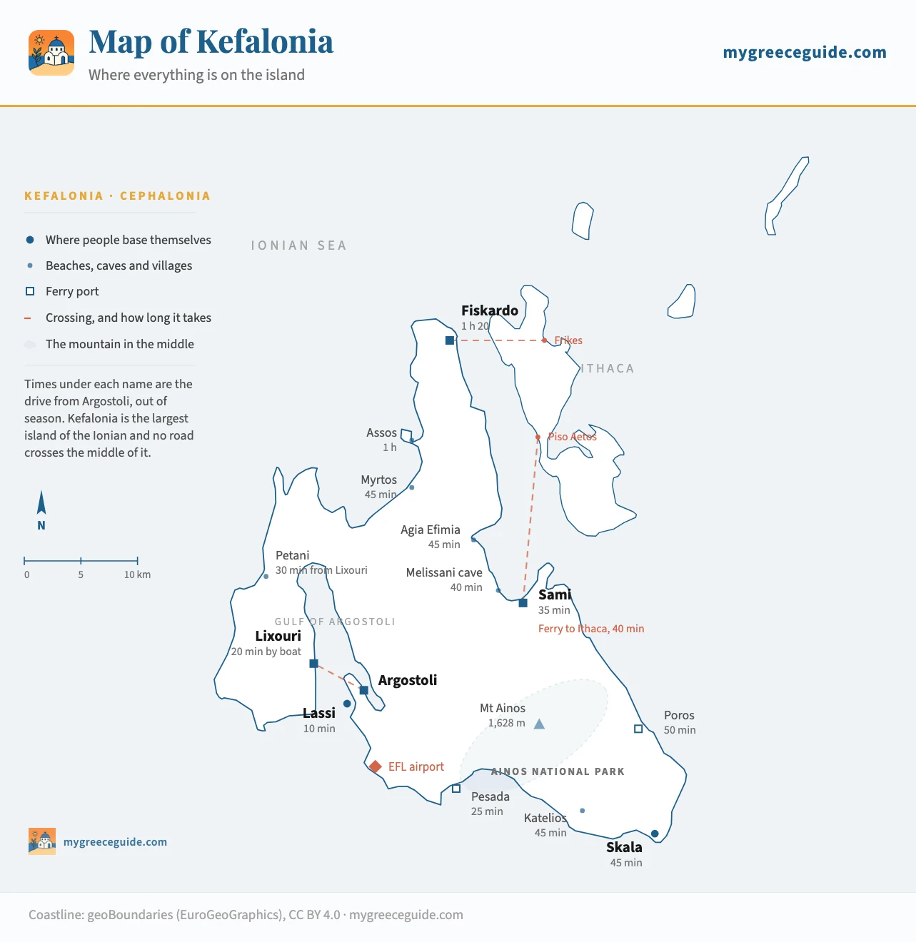
Kefalonia map: where everything is on the island
Kefalonia is the largest island of the Ionian and the worst served by its own roads. A mountain fills the middle, the villages hang off four separate arms, and the distance between two names on a booking page is never what it looks like.
Kefalonia covers 780 square kilometres, more than Corfu and nearly twice Zakynthos, and no road crosses the middle of it. Mount Ainos is in the way, so everything runs round the edges: Argostoli to Fiskardo is 50 km on paper and an hour and twenty in a car. Every place on the map below sits at its real coordinates, with that drive from the capital under its name.
It sits in the Ionian, off the west coast of Greece, which is a different country from the white and blue one most people picture, and the group is worth separating out first if you are still choosing an island.
The island
Four arms around a mountain
The shape is the whole story here. Mount Ainos rises to 1,628 m in the southern half of the island and its national park covers the ridge behind it, a fir forest that grows nowhere else on earth. Nothing goes over it, so the road network is a loop round its flanks with spurs running off in four directions, and two places that face each other across the mountain are an hour apart.
The south-west arm holds Argostoli, the capital, on a gulf so narrow it looks like a river, with Lassi and the airport on the headland below it. Paliki, the western lobe, hangs on the far side of that gulf: Lixouri is six kilometres from Argostoli across the water and 36 by road. The long northern peninsula, Erisos, runs 40 km up to Fiskardo and carries Myrtos and Assos on its west side. The fourth arm is the south-east, where Skala, Katelios and Poros have the sand.
There is one more thing the outline does not show. In August 1953 an earthquake destroyed almost every village on the island, and what stands today was rebuilt in the fifties and sixties in concrete. Fiskardo is the exception at the northern tip, far enough from the epicentre to keep its Venetian houses, which is why it looks nothing like the rest of Kefalonia and costs accordingly.
How long everything actually takes
Kilometres mislead on an island of switchbacks, so the table leads with time. These are drives outside July and August, when the coast road north fills with coaches and the descent to Myrtos queues.
| From | To | Distance | Time | Worth knowing |
|---|---|---|---|---|
| By road | ||||
| Argostoli | Lassi | 4 km | 10 min | The hotel headland, and the only stretch you can walk into town from |
| Argostoli | Sami | 25 km | 35 min | Across the waist of the island, the one road that gets you between the two coasts |
| Argostoli | Myrtos | 30 km | 45 min | North on the gulf road, then the hairpin descent from Divarata |
| Argostoli | Assos | 38 km | 1 h | Ten minutes past Myrtos, then down onto the isthmus |
| Argostoli | Fiskardo | 50 km | 1 h 20 | The whole west coast road. Longer after dark, and it is unlit |
| Argostoli | Skala | 38 km | 45 min | Round the southern flank of Ainos to the south-east corner |
| Argostoli | Lixouri | 36 km | 50 min | All the way round the gulf. The boat does it in a third of that |
| Sami | Fiskardo | 33 km | 50 min | The east coast road through Agia Efimia, narrow and slow above the water |
| Sami | Myrtos | 22 km | 35 min | Over the neck of the island at Divarata |
| Skala | Fiskardo | 85 km | 2 h | End to end. The two ends of Kefalonia are a day apart in practice |
| By boat, which is often faster | ||||
| Argostoli | Lixouri | across the gulf | 20 to 30 min | The local ferry, roughly hourly in summer. Foot passengers and cars |
| Sami | Piso Aetos | Ithaca | about 40 min | The usual way onto Ithaca, several sailings a day in season |
| Fiskardo | Frikes | Ithaca | under an hour | The northern link, and a boat on to Vasiliki on Lefkada in summer |
| Poros | Kyllini | mainland | about 1 h 30 | The car route in from the Peloponnese, year round |
| Pesada | Agios Nikolaos | Zakynthos | about 1 h 30 | Summer only, from two small ports a long way from either island's town |
Driving times are for an ordinary day outside July and August, at the pace these roads allow rather than the one a mapping app assumes. Sailing times come from the operators and the frequencies change every season, so treat the boats as a shape to plan around and check the day you travel.
The row that catches people out is Argostoli to Lixouri. Six kilometres of water, 36 km of road, and a small ferry that crosses in 20 to 30 minutes for a few euros. Book a villa on Paliki without noticing it and the whole holiday runs on the boat timetable. The same logic applies going the other way: Sami to Ithaca is 40 minutes on the water and impossible on wheels.
Myrtos, Melissani and Assos, and where they really are
The three places people arrive wanting to see are not near each other. Myrtos and Assos are on the north-west coast, twenty minutes apart, 45 minutes and an hour from Argostoli. Melissani is on the opposite side of the island, two kilometres from Sami on the east coast. Doing all three in one day means crossing the waist of the island twice, and it is a long day rather than a hard one.
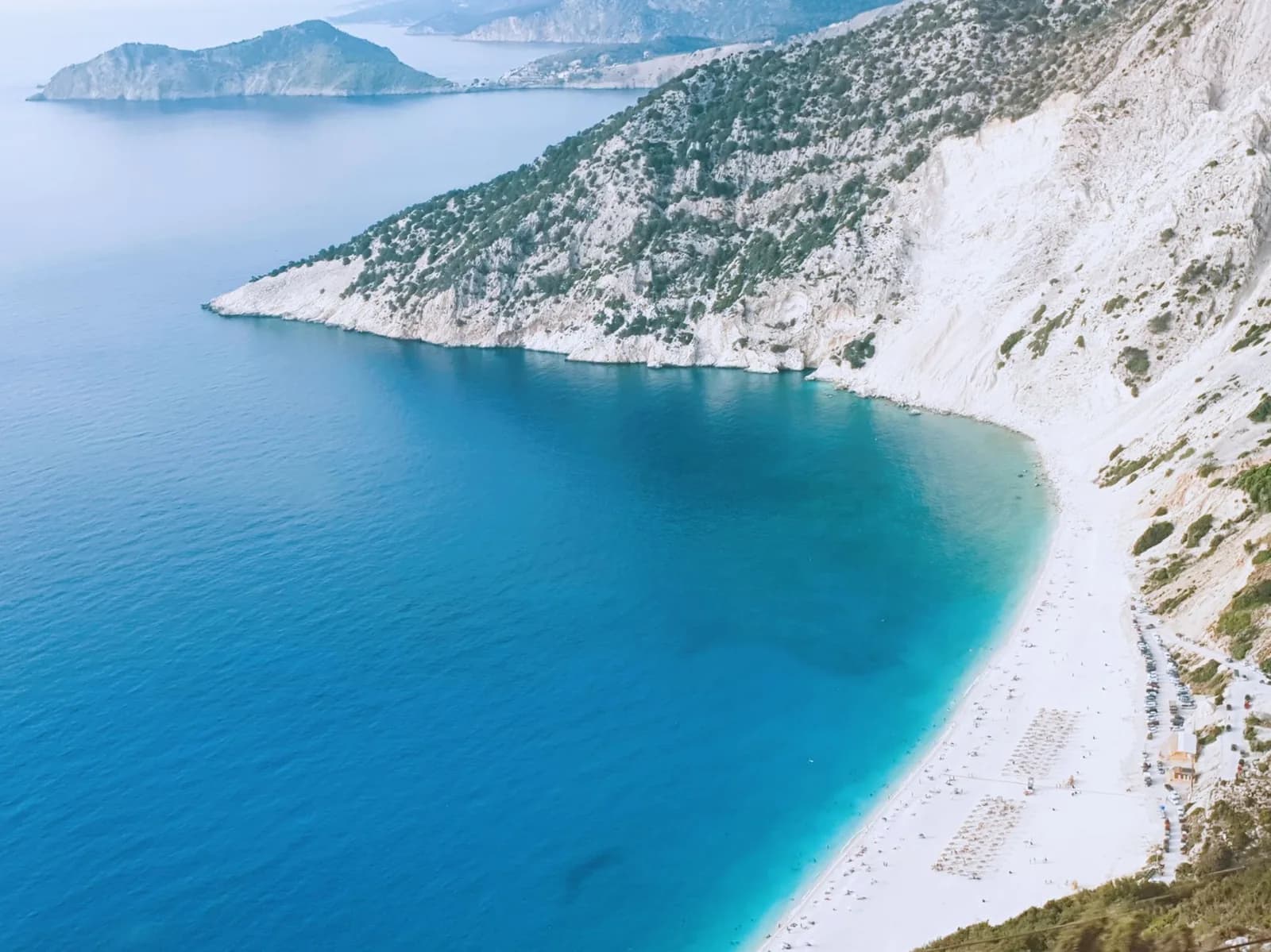
Myrtos is not a village and has nothing on it: a car park, a canteen in season, and a steep hairpin road down from Divarata. Most of the photographs are taken from a lay-by on that road rather than from the sand. The beach itself is coarse white pebble, the water drops away fast, and there is no shade after the middle of the afternoon.
Two kilometres from Sami
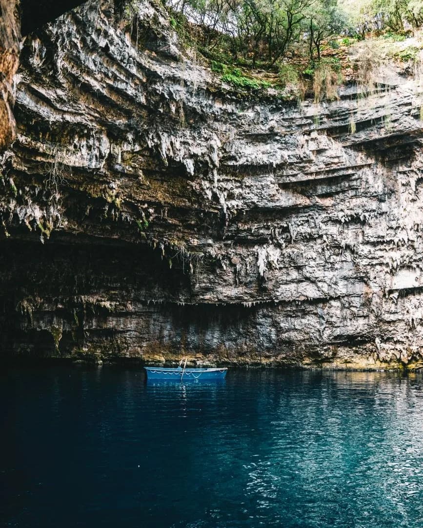
Melissani is a cave whose roof fell in, which is the reason to be there at midday rather than early: the sun comes through the hole and the lake turns. Boats leave from a jetty inside the rock and the visit takes about twenty minutes. Drogarati, a dry cave you walk into, is five minutes down the same road.
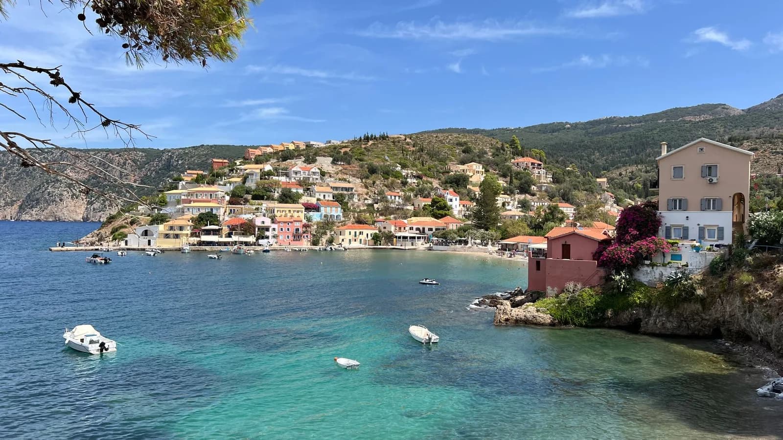
Assos is the third one, and it is a village rather than a viewpoint. It sits on a low isthmus joining the island to a wooded headland, with a Venetian fort on the top and a bay on either side, ten minutes north of Myrtos. The road down to it is a series of hairpins and the parking is tight, which is worth knowing before you take a large hire car onto it in August.
An hour from the capital
Where to base yourself, in driving time
On an island this size the base decides the holiday, because it sets what you can reach before lunch and what becomes a whole day. Pick one and the map rearranges itself around it. The hotels in each of them are in our guide to where to stay on Kefalonia.
Pick a base and see what it puts within reach
Where would you sleep?
South-west, on the gulf
- Within half an hour
- The Lassi beaches at Makris and Platys Gialos, the Argostoli waterfront and its evening promenade, the Katavothres sinkholes, the airport, and the boat across to Lixouri.
- Within an hour
- Sami and the Melissani cave in 35 minutes, Myrtos in 45, Skala in 45, Poros in 50. Almost the whole island sits inside this ring, which is the argument for basing here.
- A day out
- Fiskardo and Assos, at an hour and twenty each way. Ithaca, by driving to Sami for the boat. Both are comfortable days and neither is an afternoon.
What you give upYou are not on a beach worth a week, and you will drive somewhere every morning. You will just drive less than from anywhere else.
Why a car is not optional here
One KTEL network covers Kefalonia and every line runs out of Argostoli. It is built for people who live here: a handful of departures a day to Sami, Skala, Poros and Lixouri, fewer at weekends, and several routes that stop altogether outside the season. Nothing scheduled goes to Myrtos, nothing goes to Assos, and the northern peninsula has a service that suits a resident going to town in the morning and nobody else.
That leaves three ways to see the island: hire a car, buy organised days out, or stay in one place and swim. All three are legitimate. What does not work is booking a villa in the north on the strength of the photographs and assuming a bus will get you to dinner. The drive from the airport is the other half of the same calculation, and it runs to an hour and a half at the Fiskardo end.
Getting here, and getting to Ithaca
Kefalonia has four ferry ports and they face different directions, which is why the map marks them separately. Poros, on the south-east coast, is the car route in from the mainland, about an hour and a half from Kyllini in the Peloponnese and open all year. Sami on the east coast takes the boats from Astakos and Patras and is the main gateway to Ithaca. Fiskardo in the north links to Ithaca and, in summer, on to Lefkada. Pesada in the south has a seasonal crossing to Zakynthos from a port a long way from anywhere on either island.
None of this connects to Piraeus. The Ionian is reached from the west coast of Greece or from the air, and the way Greek ferries actually work is worth reading before you build a route out of timetables. Ithaca is the trip most people add: it has no airport, and Sami is how nearly everyone reaches it, on a half-hour crossing to Piso Aetos. Which Ithaca ferry to take, from Sami or Fiskardo, depends on where on Ithaca you are sleeping.
The neighbour to the south is harder than it looks. Zante is the next island south, and the summer boat from Pesada lands at Agios Nikolaos on its northern tip, which is an hour from the Zakynthos resorts. Corfu, at the top of the chain, has no boat at all from here. The two ends of the Ionian are joined by a flight through Athens or a long drive up the mainland, and that is usually enough to settle a two-island plan before it costs anyone a day.
Questions people ask about Kefalonia
Where is Kefalonia in the Greek islands?
On the west side of the country, in the Ionian sea, not in the Aegean where most people look for it. Kefalonia sits off the mouth of the Gulf of Corinth, with Ithaca a few kilometres east of it, Lefkada above and Zakynthos below. It is the largest island of the Ionian at around 780 square kilometres, which makes it bigger than Corfu and roughly the size of Ibiza. Athens is 260 km away over the mountains and the ferry from Kyllini into Poros takes about an hour and a half, so nobody reaches this island from Piraeus.
Which is the prettiest part of Kefalonia?
The north-west coast between Myrtos and Fiskardo, and it is not close. Myrtos is a white pebble crescent at the foot of a limestone wall, seen from a viewpoint on the road above it at Divarata. Twenty minutes further north Assos sits on a low isthmus under a Venetian fort, with a bay on either side. Fiskardo at the tip is the one village the 1953 earthquake did not flatten, so its Venetian houses are the originals. The other candidate is inland: the Melissani cave near Sami, where the roof collapsed and the sun drops onto an underground lake.
How long would it take to drive around Kefalonia?
There is no ring road to drive around, which is the first thing the map tells you. Mount Ainos fills the middle of the island and the roads work around it in a rough figure of eight, so a full circuit of the main coast roads runs to roughly 180 km and takes a full day with stops rather than an afternoon. End to end, Skala in the south-east to Fiskardo in the north, is about 85 km and two hours one way. Most people cover the island over several days from one base instead, which is what the driving times are for.
Which is the best town to stay in Kefalonia?
Argostoli if you want everything within an hour, which on this island is the argument that matters. The capital sits on the gulf in the south-west, ten minutes from the Lassi beaches and the airport, 35 minutes from Sami, 45 from Myrtos. Sami suits anyone whose plan includes Ithaca and the caves, Skala is where to sleep if the holiday is mostly sand, and Fiskardo and Assos are the prettiest and the furthest from everything else. Lixouri, across the gulf, is the cheapest and runs on a ferry timetable.
What is Kefalonia best known for?
Myrtos beach, first of all, which appears on the cover of most things written about the Ionian. Then the Melissani cave, an underground lake with a hole in its roof, and Drogarati next door. Then Captain Corelli's Mandolin, filmed here in 2000, which is still why a lot of British visitors know the name. Locally the island is known for the 1953 earthquake that levelled almost every village except Fiskardo, for Robola wine grown on the slopes of Ainos, and for the fir forest on the mountain that grows nowhere else in the world.
Do you need a car on Kefalonia?
Yes, unless you are staying put in one resort for the week. The KTEL bus network runs out of Argostoli for residents rather than for visitors: a few departures a day on the main routes, fewer at weekends, less again outside the season, and nothing at all to Myrtos, which is the beach everybody comes for. Taxis cover a gap and not a fortnight. The alternative is to base yourself in Argostoli or Sami and buy the boat trips and organised days out, which works, though it costs more than a small hire car over a week.
