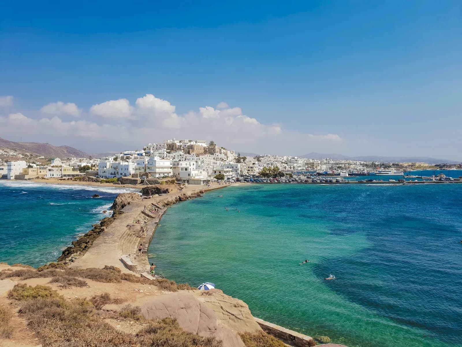
Naxos map: where the beaches, the Chora and the villages are
Naxos is 30 kilometres long with a 1,004 metre mountain across the middle of it. The sand is all on one coast, the villages are all above the treeline of that mountain, and the gap between the two is the thing every booking page leaves out.
Almost everything anyone comes to Naxos for sits in one of three places: the Chora around the port, the run of sand going south down the west coast, or a village up in the mountains. The first two are 35 minutes apart at the outside. The third is a different day. Every place on the map below is at its real coordinates, with the drive from the Chora under its name.
It is the largest island of the Cyclades and the least like the rest of them. Hold it against the rest of the group before you book anything, because the comparisons people make with Santorini and Mykonos do not survive the map.
The island
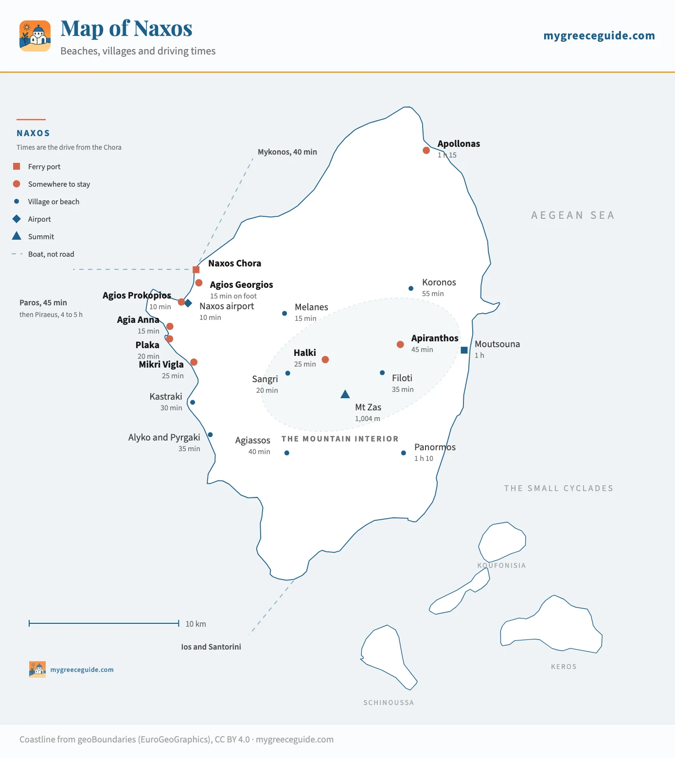
One coast for swimming, one mountain for everything else
Naxos covers 430 square kilometres, more than Paros and Mykonos put together, and the shape of it does something no other Cycladic island does. The west side is flat: a coastal plain of potato fields and olive groves with 20 kilometres of sand along its edge, and every beach on that edge is a straight run south from the town on one good road.
Then the ground stands up. Mount Zas reaches 1,004 metres, the highest point in the Cyclades by a clear margin, and the range it belongs to runs north-east across the whole island. Every village of the interior is stacked on the flanks of it, and the road that links them climbs from sea level to 600 metres in about 20 kilometres. That climb is why Apiranthos is 45 minutes from a beach it can see.
East of the ridge the island effectively stops being developed. One road drops to Moutsouna, the old port that shipped emery down a cable railway from the mines above it, and another runs south to Panormos on a surface that gives up before the end. There are no hotels worth the word out there, no bus that helps, and that is exactly why the two bays are empty in August.
How long everything actually takes
Kilometres mislead on an island where half the roads are switchbacks, so the table leads with time. These are drives outside July and August, when the coast road south fills up and the climb to Apiranthos queues behind whatever coach went up first.
| From | To | Distance | Time | Worth knowing |
|---|---|---|---|---|
| Down the west coast, where the sand is | ||||
| Naxos Chora | Agios Georgios | 1 km | 15 min on foot | The town beach. Nobody drives to it, and that is the point of staying in the Chora |
| Naxos Chora | Naxos airport | 3 km | 10 min | A single runway on the flat behind Agios Georgios. Athens propeller flights only |
| Naxos Chora | Agios Prokopios | 6 km | 10 min | The first proper beach south, and the one the buses serve every half hour in season |
| Naxos Chora | Agia Anna | 7 km | 15 min | The same strand a few hundred metres on, with the small fishing quay at its end |
| Naxos Chora | Plaka | 9 km | 20 min | Four kilometres of sand and dune. Where the crowd thins and the umbrellas stop |
| Naxos Chora | Mikri Vigla | 16 km | 25 min | A headland with a bay on each side. The north one is where the kites are |
| Naxos Chora | Kastraki | 19 km | 30 min | Emptier again, and far enough that the last bus decides your evening |
| Naxos Chora | Alyko and Pyrgaki | 22 km | 35 min | The cedar forest and the end of the sand. Nothing organised, bring water |
| Into the mountains, where the minutes double | ||||
| Naxos Chora | Melanes | 9 km | 15 min | The first valley inland, with the abandoned kouros lying in an orchard |
| Naxos Chora | Sangri | 13 km | 20 min | The temple of Demeter is ten minutes past the village on a dirt turning |
| Naxos Chora | Halki | 16 km | 25 min | The old capital of the Tragea valley. Distillery, olive press, three cafés |
| Naxos Chora | Filoti | 20 km | 35 min | The largest village on the island, on the shoulder of Zas. The climb starts here |
| Naxos Chora | Apiranthos | 26 km | 45 min | Marble lanes at 600 m. The road up is continuous hairpins from Filoti |
| Naxos Chora | Koronos | 34 km | 55 min | Houses stacked up both sides of a ravine. Slower than the distance suggests |
| Naxos Chora | Apollonas | 48 km | 1 h 15 | The northern tip, over the top and down. A day out rather than a drive |
| The far side, and across the middle | ||||
| Naxos Chora | Agiassos | 24 km | 40 min | A bay in the south with a taverna and no development. The road in is single track |
| Naxos Chora | Moutsouna | 38 km | 1 h | The old emery port on the east coast, reached over the mountain through Apiranthos |
| Naxos Chora | Panormos | 45 km | 1 h 10 | The south-east corner. The last stretch is unsurfaced and the beach is empty for it |
| Plaka | Apiranthos | 32 km | 50 min | Beach to mountain village. The cross-island run people underestimate most |
| Apiranthos | Apollonas | 22 km | 35 min | The north road along the ridge, above the emery workings |
| The full loop | back to the Chora | about 110 km | a full day | West coast, up through the villages, down to Apollonas and back along the north |
| By boat, from the same quay | ||||
| Naxos Chora | Paros | Parikia | about 45 min | Several sailings a day all year. The easiest second island from here |
| Naxos Chora | Mykonos | Cyclades | 40 min to 1 h | Fast boats in season, and the reason a fly-in fly-out pair works |
| Naxos Chora | Koufonisia | Small Cyclades | 1 h to 2 h | Depending on whether you take a fast boat or the slow island ferry |
| Naxos Chora | Santorini | Cyclades | about 2 h | High-speed only. The conventional boats take the long way round |
| Naxos Chora | Piraeus | Athens | 3 h 30 to 5 h | Three and a half on a fast boat, five on a conventional Blue Star |
Road times are for an ordinary day outside July and August, at the pace these roads allow rather than the one a mapping app assumes. The mountain figures are the ones to trust least if you are in a hurry: the climb from Filoti to Apiranthos is a continuous hairpin and a coach coming down it sets everyone's speed. Sailing times come from the operators and the frequencies change every season.
The pair of rows that catches people out is Plaka to Apiranthos. Thirty-two kilometres, 50 minutes, and it is the journey between the two halves of the island that every itinerary underestimates. Book a room on the sand and plan a village day, and that drive is the whole morning gone in each direction.
Naxos Chora, and why the port matters here
Naxos has one ferry berth and it is on the town seafront. That single fact separates this island from the two it is usually compared to. On Santorini the boats tie up at Athinios, a concrete shelf under the caldera with a hairpin road above it. On Mykonos the New Port is a bus ride from anywhere you would sleep. Here the ramp comes down onto a quay with tavernas on it, the old town is directly behind, and the island bus terminal is 40 metres along the same waterfront.
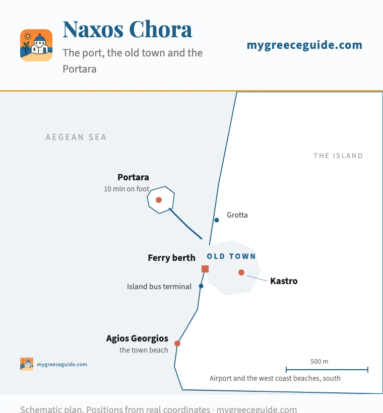
The town, at 500 m across
Everything on this plan is within about eight hundred metres of the ferry ramp. The Kastro is the Venetian citadel on the hill and the lanes up to it are stepped, which is worth knowing if you are wheeling a case. The Portara is the doorway of an unfinished temple on the islet of Palatia, reached on foot along the causeway, and it is where the town watches the sun go down.
The old town is two layers. The Bourgos is the lower one, a warren of lanes flagged in white stone between whitewashed walls, with carved marble doorframes reused from older buildings set into houses that are still lived in. Above it the Kastro is what the Venetians walled off in the thirteenth century, and a handful of the families who built it still have names on the doors.
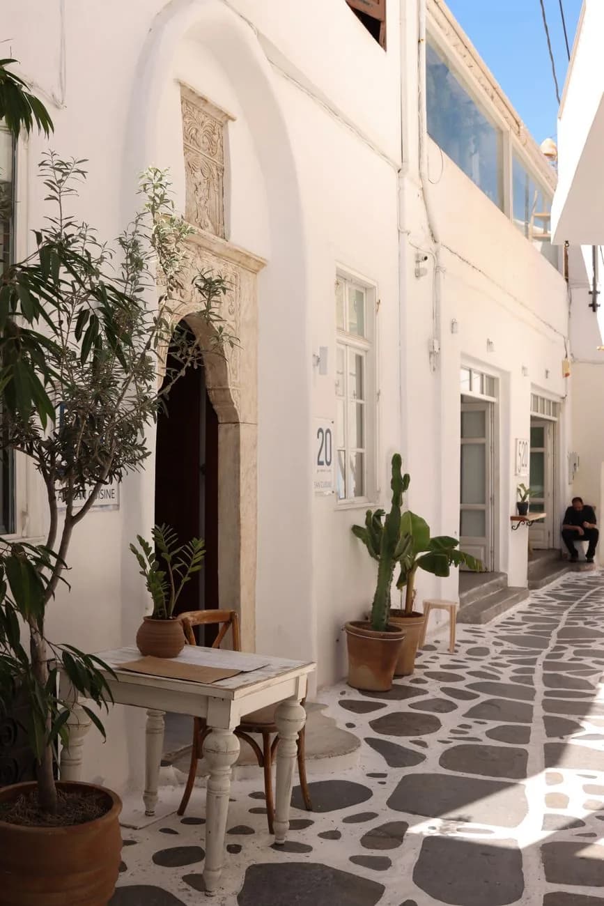
Inside the Bourgos
The lanes of the old town are flagged and outlined in white, and the marble is not decorative: Naxos has quarried it since antiquity, and a carved doorframe like this one was cut from the same rock as the unfinished kouroi still lying in the fields at Melanes.
The west coast beaches, in the order you reach them
They come in a line going south, and the rule is simple: the further you go, the emptier it gets and the more you need a car. Agios Georgios is the town beach, shallow and busy and a walk from the old town. Agios Prokopios starts the proper sand ten minutes out and takes the most buses. Agia Anna is the same strand a few hundred metres on, with a small fishing quay at the end of it.
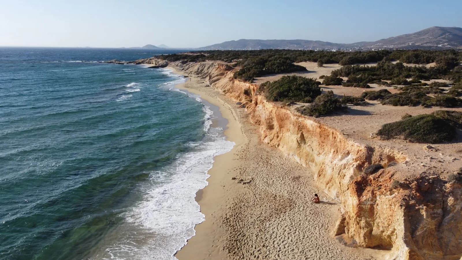
Plaka is where it changes. Four kilometres of sand backed by dune and bamboo, organised at the northern end and bare at the southern, and 20 minutes from the port. Mikri Vigla is a headland with a bay on each side, and the two behave differently: the north bay catches the meltemi and is full of kites and boards from July, the south one is sheltered enough to swim in on the same afternoon. Past there, Kastraki and then Alyko, where a juniper forest grows down onto ochre sandstone and nothing is organised at all.
The far end of the run
Halki, Filoti and Apiranthos, and the road that links them
One road goes into the middle of Naxos and it is the reason to hire a car. It leaves the Chora through Sangri, where the temple of Demeter stands in a field ten minutes off the tarmac, and drops into the Tragea, a valley of olive terraces and Byzantine chapels that is greener than anything else in the Cyclades. Halki sits in the middle of it, 25 minutes from the port: the old capital of the island, with a citron distillery that has been open since 1896 and three cafés around a square.
Filoti is the next one up, the largest village on Naxos, spread across the shoulder of Zas where the climb begins. The path to the summit starts above it, and so does the serious part of the road. Apiranthos is 10 kilometres and 20 minutes further on for a reason: the tarmac hairpins the whole way. What is at the top is a village of marble, the lanes paved in it and the houses built from it, settled by Cretans who came over in the seventeenth century and still speaking with the accent.
Beyond Apiranthos the road drops to Koronos, stacked up both walls of a ravine, and then runs down to Apollonas at the northern tip, where a ten metre kouros lies unfinished in an old quarry above the village. That is 48 kilometres from the Chora and an hour and a quarter, and going back along the north coast instead of retracing your steps makes the whole thing a loop rather than an out and back.
Bus or car, and where the line falls
Naxos has one of the better bus networks in the Cyclades and it still only solves half the island. Everything on the west coast strip is well served: Agios Prokopios, Agia Anna and Plaka get a departure every half hour or so through the summer from the terminal on the quay, and the fare is a couple of euros. The interior is a different service. Halki, Filoti and Apiranthos get a handful of runs a day, timed for a resident going to town, and Moutsouna and Panormos are effectively off the network.
So the line is clear. A week spent swimming works without a car, and a room in the Chora or on the beach strip makes that easy. A week that includes the mountains does not. The third option, in fairness, is to hire something for two days out of seven and take the bus the rest of the week. That is what a lot of people on this island end up doing.
Getting here, and Paros across the strait
Everything arrives at the same quay. From Piraeus it is three and a half hours on a fast boat and five on a conventional Blue Star, and the slower one is the more comfortable of the two in a swell. There is also a runway three kilometres south of the town taking propeller flights from Athens, which is useful for a connection and useless for luggage.
Paros is 45 minutes west and it is the obvious second island. The two face each other across a strait, the boats run several times a day all year, and the pair works because they are not the same trip: Paros has Naoussa and the better evening, Naxos has the longer beaches and the lower bill. If Athens is the start of the route, the crossing to Parikia takes roughly the same time as the one here, so which island you land on first is a question of timetable rather than geography.
North of here Mykonos is 40 minutes to an hour, which makes the fly in and fly out pair straightforward. South, Ios is about an hour and Santorini roughly two on a high-speed boat. The Small Cyclades sit off the south-east corner, and Koufonisia is between one and two hours depending on which boat you take. Look at the way the whole group connects before you commit to a route. The lines run west to east, and a plan that fights them costs days.
Questions people ask about Naxos
What is the most beautiful part of Naxos?
It depends which of the two Naxoses you mean, because the island has a coast and an interior and they look nothing alike. On the water it is the run of sand south of the Chora, and specifically the stretch from Plaka down through Mikri Vigla to Alyko, where the dunes and the cedar scrub take over and the umbrellas stop. Inland it is the Tragea, the green valley of olive terraces around Halki, and the marble lanes of Apiranthos at 600 metres above it. Most people only see the first, because the second is 45 minutes of hairpins away and there is no bus that makes it a morning.
Which is better, Santorini or Naxos?
They answer different questions. Santorini is a view, a small one, and everything on it is arranged around watching the same sunset from a caldera rim at a price that reflects how many people want to. Naxos is an island you move around in: 430 square kilometres, the largest of the Cyclades, with farmland, mountains, villages that were there before tourism and about 20 kilometres of west coast sand. If you want the photograph, go to Santorini for two nights. If you want a week that includes swimming, driving and eating for roughly half the money, Naxos.
How long does it take to drive around the island of Naxos?
There is no coastal ring road to drive around, and that is the first thing the map tells you. Mount Zas and the range behind it fill the middle and the east coast has almost no road at all, so the circuit people actually do is a loop: down the west coast, up through Halki and Filoti to Apiranthos, north to Apollonas, and back along the north coast. That is about 110 kilometres and a full day with stops, not an afternoon. End to end, the Chora to Apollonas, is 48 kilometres and an hour and a quarter one way.
Is Naxos nicer than Paros?
Naxos is bigger and cheaper, Paros is prettier in the evening. Paros has Naoussa, so it takes the better dinner and the higher bill, and Parikia takes more ferry lines, so it is the stronger base if you are hopping between islands. Naxos has the longer beaches, a mountain interior with real villages in it, and a port town you can walk out of the ferry into. The two are 45 minutes apart by boat and there is no rule that says you pick one, which is why the pairing is the most common two island trip in the Cyclades.
Do you need a car on Naxos?
Not for the beaches, yes for everything else. The bus out of the Chora runs to Agios Prokopios, Agia Anna and Plaka every half hour or so in season, which covers the whole reason most people come, and Agios Georgios is a walk from the old town. What the timetable does not cover is the interior: Halki, Filoti, Apiranthos, Koronos and Apollonas get a few departures a day, built around a villager going to town in the morning and back in the afternoon. Moutsouna and Panormos get less than that. On an island 30 kilometres long with a 1,004 metre mountain in the middle, that is the difference between seeing the coast and seeing Naxos.
Where is Naxos on the map of Greece?
In the middle of the Cyclades, in the Aegean, roughly 190 kilometres south-east of Athens. Paros is directly west across a strait, Mykonos is north, Ios and then Santorini are south, and the Small Cyclades of Koufonisia, Schinoussa, Iraklia and Donousa are scattered off the south-east corner. Piraeus is three and a half hours away on a fast boat and five on a conventional one, and there are Athens flights on a small propeller aircraft into a runway three kilometres from the town.
