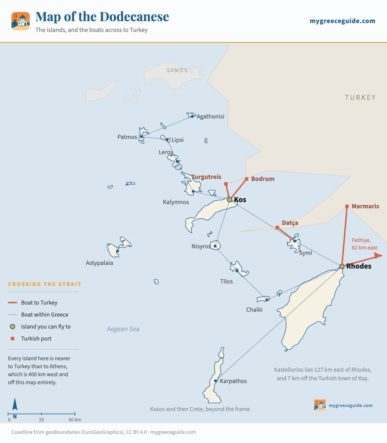
Map of the Dodecanese: the islands, and the boats to Turkey
Fifteen inhabited islands strung along the Turkish shore for 250 km, and every one of them nearer to Anatolia than to Athens. Most maps of this group leave the second coastline blank. That is the half that decides what you can do here.
Every other map of the Dodecanese draws Greece and stops at the water. This chain has two coastlines, not one. Kos Town is 13 km from Turgutreis and 21 km from its own airport; Kastellorizo is 7 km from Turkey and 138 km from the nearest runway. The map below draws the boats that cross the border alongside the ones that stay in Greece, because on this group those are the same decision.
Two coastlines
Every island in the group, north to south and measured
Alphabetical lists of these islands are everywhere and none of them tell you anything. Ordered the way the chain actually runs, with the two distances that decide a trip drawn to the same scale, the shape of the group gives itself away. Switch the measure and watch which islands change places.
Measure the chain against
How far is it to
Agathonisi
Three hamlets and a harbour, closer to Turkey than to anything Greek that sells a ticket
56 km to Turgutreis, no boat
Patmos
The monastery and the cave of Revelation. Cruise ships by day, silence after
72 km to Turgutreis, no boat
Lipsi
One village, a dozen beaches, and a boat that meets the Patmos catamaran
54 km to Turgutreis, no boat
Leros
Italian rationalist architecture at Lakki and the deepest bays in the group
39 km to Turgutreis, no boat
Kalymnos
Sponge diving, then rock climbing. A working port rather than a resort
25 km to Turgutreis, no boat
Kos
Flat, cyclable and ancient. The northern gateway, and the shortest hop to Turkey
13 km to Turgutreis
Nisyros
A volcanic crater you walk down into, still steaming, on a day boat from Kos
44 km to Turgutreis, no boat
Symi
The ochre harbour everyone photographs, emptied of day trippers by six
18 km to Datça
Astypalaia
Out west towards the Cyclades and Cycladic to look at. The thin connections start here
95 km to Turgutreis, no boat
Rhodes
The medieval town, 80 km of coast and the southern gateway. Flights until late October
46 km to Marmaris
Tilos
No package trade, protected all over, and the walking is the point
44 km to Datça, no boat
Chalki
One waterfront of restored houses. Reached from the west coast of Rhodes
56 km to Datça, no boat
Kastellorizo
The far outpost. You can swim towards Turkey and the border is the reason not to (beyond the frame of the map above)
7 km to Kaş
Karpathos
Long, mountainous and windy, with the old dialect surviving at Olympos in the north
142 km to Datça, no boat
Kasos
The last island before Crete. Five villages, one boat, and nobody on it (beyond the frame of the map above)
161 km to Datça, no boat
Distances are straight lines between ports, worked out from real coordinates and rounded to the kilometre, on one scale across every row. A solid bar on the Turkish measure means a boat actually crosses; a pale one means the water is that narrow and nothing sails it.
Two things fall out of that. Nearness to Turkey buys you nothing on its own, because eleven of these fifteen islands look at a coast they have no boat to. And the islands that are awkward to reach from Turkey are usually awkward to reach from Greece too, which is why Kastellorizo, at 7 km from Kaş and 138 km from Rhodes, is the strangest row in the table and the one that explains the group best.
Where the chain actually sits
The group runs down the south-west corner of Turkey for roughly 250 km, from Agathonisi in the north to Kasos in the south, with Kastellorizo hanging out east on its own. It is the eastern edge of the Aegean and the eastern edge of the European Union, and the frontier is drawn tight against the Anatolian shore rather than down the middle of the sea.
That geography is the reason the group behaves the way it does. Greek ferries radiate out of Piraeus, so a chain 400 km from Piraeus and 20 km from Turkey ends up served by its own local network rather than by the national one. It is also why the season lasts longer here than anywhere except Crete, and why picking between Rhodes, Kos and the dozen smaller islands works differently from picking a Cycladic island.
The neighbours are worth fixing in your head, because this is the group people place wrongly most often. The Cyclades, with Santorini and Mykonos, are in the middle of the Aegean, well to the west, and there is a great deal of open water in between. The six island groups laid out across both Greek seas settles it faster than reading about it. Crete is south-west, past Kasos. The islands further up the Turkish coast, Samos, Chios and Lesbos, look like more of the same on a map and belong to a different group with different boats.
The boats to Turkey, island by island
Six crossings, from four islands. This is the table nobody publishes, and the reason it matters is that the water on this map is misleading: the shortest gaps and the busiest boats are not on the same islands. Distances are measured port to port. Times run from the fast catamaran to the conventional ferry, since both are sold on the same quay at very different prices.
| Crossing | Across | At sea | When it runs | Worth knowing |
|---|---|---|---|---|
| From Kos, in the northThe narrowest water in the group, and the only crossing that keeps a timetable through most of the winter. Both boats leave from the quay in Kos Town, a few minutes from where the ferries to the other Greek islands tie up. | ||||
| Kos to Bodrum | 20 km | 20 min to 1 h | Daily, most of the year | The catamaran does it in twenty minutes and the older ferries take an hour for less money. Bodrum is a proper city with a castle and a bazaar, which is why this is the crossing people actually make |
| Kos to Turgutreis | 13 km | 30 to 45 min | Daily in summer | Shorter on the water and quieter at the other end, since Turgutreis is a resort town rather than a city. A smaller boat, so a windy morning cancels this one before it cancels Bodrum |
| From Symi and Rhodes, in the southLonger water and thinner timetables. These are the crossings that disappear first in October and come back last in May, and the Symi one has never been an everyday service. | ||||
| Symi to Datça | 18 km | 1 h to 1 h 30 | A few a week, June to September | The thinnest of the international links. Datça sits on a long peninsula with almost nothing on it, so this is a crossing for people going somewhere in Turkey rather than for a day out |
| Rhodes to Marmaris | 46 km | 50 min to 2 h | Daily in season | The classic day out from Rhodes. Catamarans do it in under an hour, the conventional car ferry closer to two, and the last boat back is early enough that missing it means a night in Turkey |
| Rhodes to Fethiye | 82 km | 1 h 30 to 2 h | A few a week, summer only | Sold mostly as a way of reaching the Turkish coast rather than as an excursion, because the water is long enough that a day return leaves you barely three hours ashore |
| From Kastellorizo, out eastOff the map above, 127 km east of Rhodes Town and 7 km off the Turkish shore. The border here is not an abstraction, it is the view from the harbour. | ||||
| Kastellorizo to Kaş | 7 km | 20 to 30 min | Daily in season, a few a week otherwise | The shortest crossing between Greece and Turkey anywhere. The town on the far side has more people in it than the island does, and islanders use this boat the way other people use a bus |
What the border actually costs you
Twenty minutes on a boat, and a full external frontier of the European Union at the other end. Four things follow from that, and the third one ruins people's trips every summer.
Everyone on the boat needs a passport. A national identity card will not do it and a driving licence is not close. Entry requirements for Turkey differ by nationality and have changed more than once in recent years, so check yours rather than assuming.
A single-entry Schengen visa is spent the moment the boat leaves Greek water. You will not be allowed back in on it, and finding that out at the passport desk in Bodrum on the last evening of a holiday is a bad way to spend a night. If your visa is single-entry, the day trip is not available to you. This is the one that catches people out, every single season.
The hire car stays in Greece. Rental contracts here do not permit the vehicle to leave the country, and most do not permit it to leave the island either, so the insurance is void the moment it rolls onto a ferry ramp. Leave it at the port and pick it up when you come back. Where you are based on Rhodes decides how far that drive to the port is, which matters more than it sounds when the boat leaves at half past eight.
And the last boat back is earlier than anyone expects. Most return sailings leave the Turkish side in the late afternoon, which makes a day trip a morning and a lunch rather than a day and an evening. Miss it and you are booking a room in Turkey, because there is no later option and no other way across.
The boats that stay inside Greece
The thin blue lines on the map, and the network that carries almost everyone. It splits at Kos: a northern half of short hops on daily catamarans, and a southern half of longer legs on fewer sailings. One crossing joins the two, and how comfortable you are with a four-hour boat decides whether the whole chain is one trip or two.
| Crossing | Across | At sea | When it runs | Worth knowing |
|---|---|---|---|---|
| The northern half, out of KosShort hops on catamarans that work the chain daily in season. This is the easy half of the group, and four islands in a week is a realistic plan here. | ||||
| Kos to Kalymnos | 28 km | 30 to 60 min | Several a day | The shortest useful hop in the group and the reason Kalymnos works as an add-on rather than a trip |
| Kalymnos to Leros | 23 km | 30 to 50 min | 1 to 3 a day | Same boats continuing north, so the connection is usually the sailing you are already sitting on |
| Leros to Lipsi | 20 km | 20 to 40 min | 1 to 2 a day | A small boat on a timetable written for islanders, which means early and not negotiable |
| Lipsi to Patmos | 20 km | 20 to 40 min | 1 to 2 a day | The last rung north. Patmos has no airport, so everyone arrives this way or on the overnight ship from Piraeus |
| Kos to Patmos | 81 km | 2 h 30 to 3 h 30 | Daily in season | The direct catamaran, skipping the middle. Worth it northbound, and worth breaking on the way home |
| Kos to Nisyros | 33 km | 1 h to 1 h 30 | Most days in season | Mostly sold as a day boat to the volcano, which leaves early and returns mid-afternoon |
| The southern half, out of RhodesLonger legs, fewer boats, and one crossing that ties the two halves together. Nothing here is a bad idea, but two islands in a week beats four. | ||||
| Rhodes to Symi | 39 km | 50 min to 1 h 40 | Several a day | The busiest crossing in the south, and almost all of it is day trippers. Stay a night and you get a different island after six |
| Rhodes to Chalki | 63 km | 1 h 15 to 2 h | A few a week | Also reachable on a local boat from Skala Kamirou on the west coast of Rhodes, which is quicker but needs a car to reach |
| Rhodes to Tilos | 75 km | 1 h 30 to 2 h 30 | A few a week | Thin enough that the return sailing decides the length of your stay before you do |
| Rhodes to Kos | 97 km | 2 h 15 to 4 h | Daily in season | The link between the two halves of the group, usually calling at Symi, Tilos or Nisyros on the way |
| Rhodes to Karpathos | 139 km | 4 h to 6 h | 2 to 3 a week | Long, exposed and often rough. Most people fly this leg from Rhodes or Athens instead |
| Karpathos to Kasos | 28 km | 30 to 50 min | A few a week | The last rung before Crete, on the same boats that continue to Sitia |
Routes the map makes obvious
Put a finger on your airport and read outwards. The group rewards short chains built around one gateway, and it punishes anything that tries to cover both ends in a week.
Rhodes, Symi and a morning in Marmaris is the strongest week in the south, and it uses the border rather than ignoring it. Base yourself in Rhodes Town so the ferry quay and the Old Town are both a walk away, which the layout of the island argues for anyway, give Symi two nights so you see it after the day boats leave, and take the catamaran across for one day. Three quite different places, no internal flights, and one passport stamp.
Kos, Kalymnos, Leros and Patmos is the northern equivalent and the easier of the two, because every leg is under an hour and the boats run daily. Fly into Kos, work north, come back for the flight. The airport sits in the middle of the island at Antimachia rather than beside the port, so build the transfer into the first and last day instead of discovering it, and where Kos Town, Kardamena and Kefalos actually fall decides whether you need a car at all. Add Bodrum for a day at the start and the week has a city in it.
What the map argues against is just as useful. Rhodes to Patmos and back in a week is four hours of boat each way for two nights at the far end. Karpathos on a chain does not work: it is two to three sailings a week from Rhodes and often rough, so treat it as a destination you fly to rather than a stop. And Astypalaia looks like a bridge to the Cyclades on the map and is not one, since the seasonal line that links it to Naxos runs a couple of times a week in high summer and nothing else does.
One habit worth keeping whichever route you take. Never put a crossing on the day you fly home, in either country. The wind here is less punishing than the meltemi in the Cyclades, but the small boats on the thin lines still stop sailing, and a cancelled sailing on a border crossing costs you a passport queue as well as a flight.
Questions people ask about the map of the Dodecanese
Which country owns the Dodecanese islands?
Greece, since 7 March 1948, which makes them the most recent addition to the Greek state. The map explains why the question gets asked at all: every island in the group is closer to Turkey than to the Greek mainland, and Kastellorizo is 7 km from the Turkish town of Kaş and 138 km from the nearest Greek airport. The islands were Ottoman until 1912, then Italian for thirty years, which is why Leros has rationalist architecture and Rhodes has a restored medieval town. The border in the water has been settled for three quarters of a century and it is a normal EU external frontier, with passport control on both sides.
Which islands are in the Dodecanese?
The fifteen with a port, somewhere to sleep and a boat that calls are Rhodes, Kos, Karpathos, Kalymnos, Patmos, Leros, Symi, Astypalaia, Tilos, Nisyros, Chalki, Kasos, Lipsi, Agathonisi and Kastellorizo. Rhodes and Kos are the only two you can fly to from outside Greece. Kasos and Kastellorizo sit beyond the edges of the map above, one on the way to Crete and the other far out east against the Turkish coast.
Why are they called the Dodecanese islands?
It means twelve islands, from the Greek dodeka and nisos, and the count has never matched the map. The label came out of the nineteenth century and described the twelve islands that held certain privileges under Ottoman rule, a list that did not originally include either Rhodes or Kos. The administrative group today holds fifteen inhabited islands and more than a hundred uninhabited rocks. Nobody who lives there counts them.
How close are the Dodecanese islands to Turkey?
Close enough to see across on every island in the northern half of the chain. Kos Town is 13 km from Turgutreis and 20 km from Bodrum. Symi is 18 km from Datça. Kastellorizo is 7 km from Kaş, which is the shortest distance between Greece and Turkey anywhere. Rhodes is the furthest of the islands with a crossing, at 46 km from Marmaris. For comparison, Athens is about 400 km west of Rhodes, so the second country really is nearer than the capital.
Can you take a ferry from Rhodes or Kos to Turkey?
Yes, and it is an ordinary thing to do. Kos to Bodrum takes between twenty minutes and an hour depending on the boat and runs most of the year. Rhodes to Marmaris takes under an hour on the catamaran and closer to two on the conventional ferry, daily through the season. Symi to Datça, Rhodes to Fethiye and Kastellorizo to Kaş exist too, on thinner seasonal timetables. All of them are full international border crossings, so you need a passport, and a single-entry Schengen visa is used up the moment you leave Greece.
Which is the largest island in the Dodecanese?
Rhodes, at about 1,400 square kilometres, which puts it fourth among all Greek islands behind Crete, Evia and Lesbos. It is roughly 80 km from the medieval town at the northern tip to the empty south, an hour and three quarters of driving. Karpathos comes second by area and feels larger still, because the road over its mountain spine is slow.
Is there a printable map of the Dodecanese?
The map on this page is an image file rather than an embedded Google map, so it saves and prints like a photograph and it opens on a phone with no signal, which describes most of the water between these islands. It is drawn from real coordinates, so the distances on it are true and the scale bar works. What it cannot be is a timetable: seasonal crossings appear and vanish every year, so check the day you are travelling before you rely on a line.
