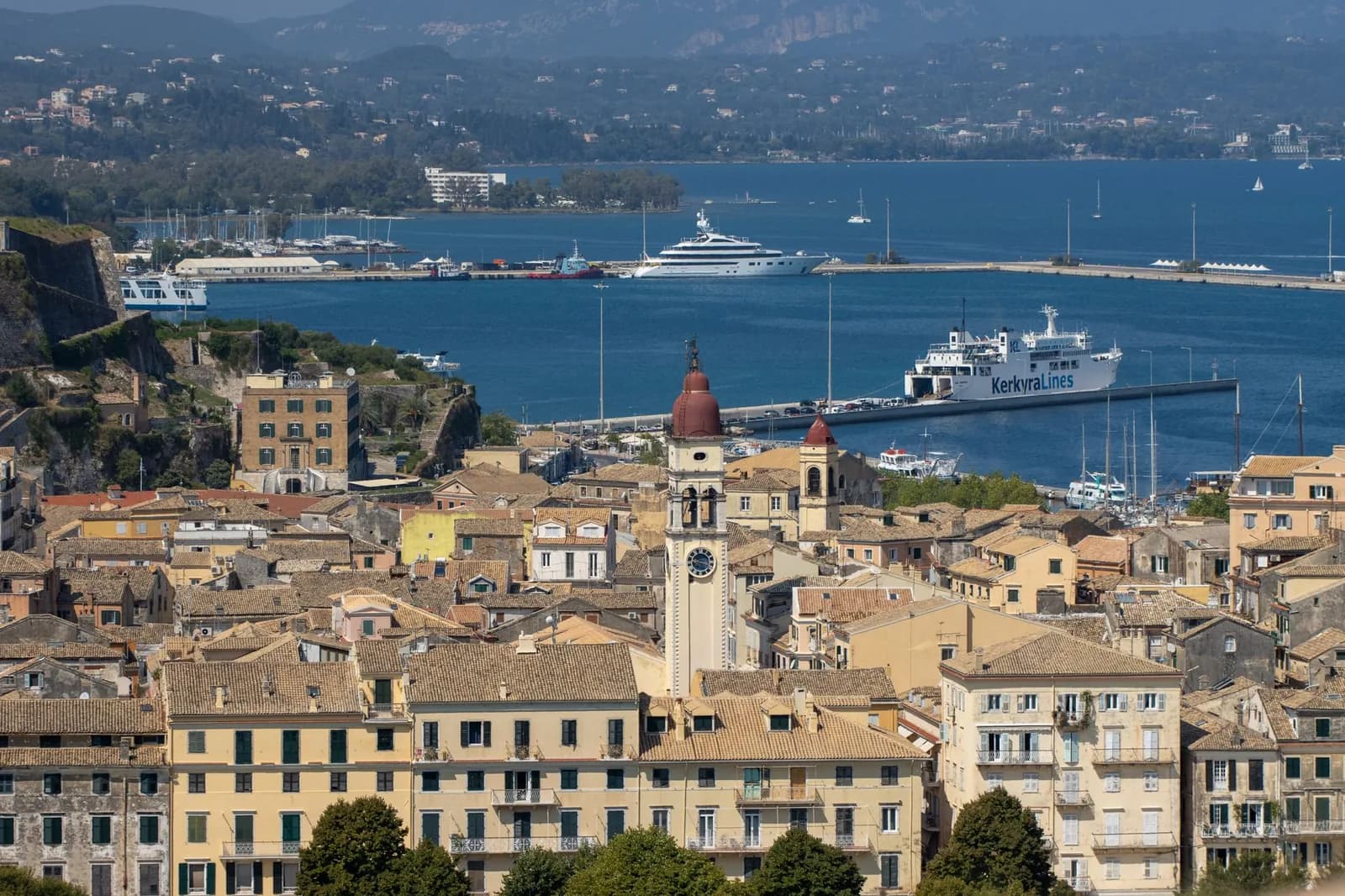
Map of the Ionian islands: the chain, and the ways in
Six islands down the western side of Greece, on the wrong side of the country for Athens and the right side for Italy. Where they sit is the easy half. Which boat reaches which one is the half that decides the trip.
Every other map of the Ionian islands stops at the Greek coast, and in doing so it hides the thing that makes this archipelago different from every other group in the country. These islands are reached from Italy. Four Adriatic ports send ships across, one of them lands on an island and three of them do not, and no ferry at all comes here from Piraeus. The map below opens the frame as far as Venice, because that is where the journey actually starts for a lot of people.
The Adriatic approach
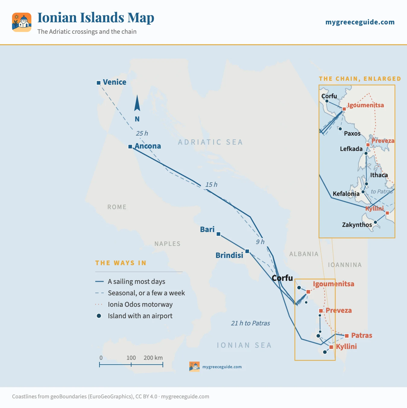
Three things fall out of the drawing. Corfu is the gate, the only island in Greece with a scheduled ferry from another country, which is why it has a town rather than a resort strip at its centre. Igoumenitsa does the work, and it is a port and nothing else, so nobody stays there. And the chain is longer than it looks: Corfu to Zakynthos is 200 km with no boat between them, so the two ends of this group belong to two different holidays.
The crossings from Italy, port by port
Four ports, and the choice between them is a trade between hours in the car and hours on the boat. Bari and Brindisi are the short ones, eight to eleven hours, almost always overnight, which is the cheap way if you are already in the south of Italy and the long way round if you are not. Ancona saves you the entire drive down the Adriatic coast and charges you a full day at sea for it. Venice is the same trade taken further, and it is the least reliable line of the four.
The operators on this route change hands more often than anywhere else in Greek shipping. Superfast, Minoan, Grimaldi, ANEK and Ventouris have all held pieces of it, ports have been added and dropped, and Trieste has stood in for Venice more than once. Times below are the ones the schedules have held to for several seasons. Treat the port pairs as durable and the company names as not.
| Crossing | At sea | How often | Worth knowing |
|---|---|---|---|
| The short crossings, from the heel of ItalyBari and Brindisi sit closest to Greece and their boats mostly sail overnight. You board in the evening, you sleep, and the ramp goes down on the far side after breakfast. These are the sailings to want if you are driving. | |||
| Bari to Igoumenitsa | 8 to 11 h | Daily, year-round | The workhorse of the route. Mostly overnight, and the arrival puts you an hour and a half from Corfu |
| Bari to Corfu | 8 to 10 h | Most days in season | The only direct sailing from Italy onto an Ionian island. Thins out sharply from late October |
| Brindisi to Igoumenitsa | About 8 h | Seasonal, several a week | The shortest hop of the lot on paper, and the least dependable timetable of the four ports |
| Brindisi to Corfu | 6 to 8 h | Summer only | Runs when the season justifies it. Worth checking rather than planning around |
| The long ones, from the Adriatic portsAncona and Venice are further up the coast, which buys you a day at sea instead of a night. In exchange you drive far less of Italy, and that trade decides which port most people pick. | |||
| Ancona to Igoumenitsa | 15 to 17 h | Daily, year-round | The busiest line between the two countries, and the one with the most operators on it |
| Ancona to Patras | 21 to 23 h | Daily, year-round | Same boat, six hours further. It rounds the whole archipelago to reach the gulf |
| Venice to Igoumenitsa | 24 to 28 h | Seasonal, and it moves | The thinnest line on the map. It has changed operator and port several times, and Trieste has stood in for it |
| Venice to Patras | 30 h and up | Seasonal | More than a day and a night at sea. Taken for the car it carries, not for the crossing |
| Once you have landedIgoumenitsa and Patras are ports, not destinations, and neither is on an island. These are the connections that finish the job. | |||
| Igoumenitsa to Corfu | 40 min to 1 h 30 | 10 or more a day | Fast boat or conventional ferry, both take cars. The densest crossing in western Greece |
| Igoumenitsa to Paxos | About 1 h 30 | A few a week, in season | Thin. Corfu is the usual door to Paxos, and it has several boats a day |
| Kyllini to Zakynthos | About 1 h 15 | 4 to 7 a day | An hour south of Patras by road, and the standard way onto Zakynthos without flying |
| Kyllini to Kefalonia | 1 h 15 to 1 h 45 | 2 to 4 a day | Lands at Poros, on the eastern shore. Argostoli is another 40 minutes of driving |
| Patras to Kefalonia | About 3 h | Seasonal | Sails to Sami. Convenient when it runs, and it does not run all year |
The pattern in the table is the six-hour penalty on Patras. Ancona to Igoumenitsa and Ancona to Patras are frequently the same ship: it drops one set of ramps in Epirus, then spends another six hours rounding Corfu, Kefalonia and Zakynthos to reach the gulf. If your island is Corfu, Paxos or Lefkada, getting off at Igoumenitsa saves you those hours. If it is Zakynthos, staying aboard to Patras saves you most of a day of driving. The decision is made when you book, not at the port.
The one Greek archipelago you can drive to
No other group in Greece works this way. The Cyclades and the Dodecanese are reached by leaving the car somewhere, but the Ionian islands run alongside a motorway. The Ionia Odos comes down from Igoumenitsa past Ioannina and Arta to the bridge at Rio, and it puts the whole chain within a few hours of the Adriatic ramp. Roughly an hour and a quarter to Preveza, under two to Lefkada, about three to Patras, another hour from there to Kyllini for the Zakynthos boat.
Lefkada goes one step further and needs no boat at all. A causeway and a swing bridge carry the road across a 50 m channel, so you drive onto the island the way you would drive into a town. It is one of only two Greek islands you can reach without a ferry, and it explains why Lefkada fills with Italian and Balkan number plates in August while its neighbours do not. The guide to which of these islands suits which kind of week goes into what that does to the place.
The catch is the price of taking a car across the Adriatic. A vehicle roughly doubles a crossing, and on the long Ancona sailings a cabin on top of it turns a ferry ticket into the largest single line of the trip. Two things follow. Over a week on one island, hiring on arrival usually costs less than shipping your own. Over three weeks touring the mainland and the chain, bringing the car wins, and it wins by a lot.
Where the chain actually sits
The group runs down the west coast of Greece, in the sea that separates it from Italy. Corfu is at the top, at 39.6 degrees north, level with Naples and closer to the Albanian shore than to any other Greek island: the strait north of the town is under 3 km wide. Zakynthos closes the chain 200 km south, off the western Peloponnese. Between them, Kefalonia is the largest island of the seven at 781 km² and the largest in Greece after Crete, Evia, Lesbos, Rhodes and Chios.
The distance that matters is the one to Athens. Piraeus is on the other side of the country and sends nothing here, which catches out a great many trips built on the assumption that Greek ferries radiate from the capital. From Athens the Ionian is a domestic flight, or four to six hours of driving west, or a bus. Nothing about it resembles walking onto a boat at Piraeus. The six island groups laid out across both seas is the two-minute version if the names are still interchangeable.
The seventh island is the one to set aside. Kythira is Ionian on paper and nowhere near the others, hanging off the southern tip of the Peloponnese between Cape Malea and Crete, 200 km from Zakynthos with no connection to it. Venice and then Britain administered it with the Eptanisa and the label survived the empires. Nobody combines it with the rest.
Every island, and the door it opens through
Read this the way the map is drawn, by gateway rather than alphabetically. The right-hand column is the one that surprises people, and it is the reason this page exists: one island in seven takes a ship from Italy.
| Island | Runway | Where the boat lands | Reached from | Direct from Italy |
|---|---|---|---|---|
| The northern pair, out of IgoumenitsaCorfu and Paxos sit off Epirus, level with the heel of Italy. This is the half of the group the Adriatic boats reach. | ||||
| Corfu | CFU, on the edge of town | Corfu town, New Port | Igoumenitsa, 40 min to 1 h 30 | Yes, from Bari and Brindisi |
| Paxos | None | Gaios | Corfu, about 1 h | No |
| The middle three, out of Preveza and AstakosLefkada, Ithaca and Kefalonia are close enough together to be treated as one destination, and this is the only corner of the group where island hopping works the way it does in the Aegean. | ||||
| Lefkada | PVK at Preveza, 25 km away | No ferry needed | A causeway and a swing bridge | No |
| Ithaca | None | Piso Aetos, Vathy, Frikes | Kefalonia or Astakos, 40 min to 2 h | No |
| Kefalonia | EFL, 9 km from Argostoli | Sami, Poros, Pesada, Fiskardo | Kyllini or Patras, 1 h 15 to 3 h | No |
| The southern end, out of KylliniZakynthos hangs off the western Peloponnese, four hours by road from Igoumenitsa and a world away from Corfu in practice. | ||||
| Zakynthos | ZTH, 5 km from town | Zakynthos town, Agios Nikolaos | Kyllini, about 1 h 15 | No |
| Kythira | KIT, small and seasonal | Diakofti | Neapoli in Laconia, about 1 h | No |
Two absences do most of the work. Paxos and Ithaca have no runway, so neither can start or end a trip, and both stay quieter than their neighbours for exactly that reason. Lefkada has no runway either but sits 25 km from one, at Preveza, which is close enough that charter flights sell it as a Lefkada airport. Kefalonia airport and the drive times from it covers the other end of that arithmetic, where the runway is on the island but the island is two hours wide.
What links the islands, and where it stops
The middle of the chain works. Lefkada, Ithaca and Kefalonia sit within sight of each other and are joined by short crossings out of Nydri and Vasiliki, Sami, Piso Aetos and Fiskardo, run by Ionian Group, Levante Ferries and Kefalonian Lines. A week across those three behaves the way a week in the Cyclades behaves, and it is the only itinerary in the group that does.
Both ends are cut off. There is no boat from Corfu south to Kefalonia and there never has been a commercial reason for one: getting between them means the ferry back to Igoumenitsa and most of a day down the motorway. Where the resorts and the old town sit on Corfu is worth reading before you assume it combines with anything. At the southern end, Zakynthos is joined to Kefalonia by one summer sailing between Agios Nikolaos and Pesada, two small ports at the far ends of both islands from where anybody sleeps.
So the honest reading of the map is three destinations rather than one archipelago. Corfu and Paxos in the north. The Lefkada, Ithaca and Kefalonia triangle in the middle. Zakynthos on its own in the south. Moving between those three is done by road, and it takes the best part of a day each time.
What the green comes from
Using this map once you are out there
One advantage this group has over the Aegean is worth stating plainly. The meltemi does not blow here. The north wind that shuts fast ferries between the Cyclades for days at a time in July and August is an Aegean phenomenon, and the Ionian crossings are short and sheltered besides. A cancelled sailing is a rare event on this side of the country, which is one reason the charter yacht fleet is based at Lefkada and Corfu rather than anywhere further east.
The risk that replaces it is the calendar. The Adriatic lines run all year on the Bari and Ancona pairs and shrink to almost nothing on the rest: Brindisi and Venice come and go, the direct Corfu sailings thin from late October, and the Pesada crossing to Zakynthos exists only in high summer. The airports follow the same curve, because they live on charter flights rather than on scheduled ones, and from late October only Corfu carries on as a place you can simply turn up to.
Two habits follow. Never put an Adriatic crossing on the day you fly home from Italy, since a fifteen-hour sailing that leaves two hours late still leaves two hours late. How Greek ferry booking works, company by company covers the part that is messier than the sailing itself. And on any leg that carries a car, hold the ticket before you leave home: deck space goes late, vehicle space and cabins go weeks early, and on this route those are the two things you cannot improvise.
Questions people ask about the Ionian islands map
What are the 7 Ionian Islands?
Corfu, Paxos, Lefkada, Ithaca, Kefalonia, Zakynthos and Kythira. The Greek name for the group, Eptanisa, means exactly that: seven islands. The seventh is the odd one, because Kythira sits off the southern tip of the Peloponnese, 200 km from the rest, and has nothing to do with any of them in practice. It was grouped in for administrative reasons under Venice and the British, and the label stuck. A traveller planning an Ionian trip is planning around six.
Can you get to the Ionian islands from Italy?
To one of them, directly. Corfu takes boats from Bari and, in summer, Brindisi. Everywhere else in the group is reached by sailing to Igoumenitsa or Patras on the Greek mainland and continuing by road or on a second ferry. That is the single most useful thing to know about this archipelago and the thing almost no map of it shows: Ancona, Bari, Brindisi and Venice all send ships across the Adriatic, but they land you in Greece rather than on an island.
What are the ferry routes to the Ionian Islands?
Four Italian ports and three Greek gateways. From Italy, Bari and Brindisi are the short overnight crossings, eight to eleven hours; Ancona is fifteen to seventeen hours to Igoumenitsa and about twenty-one to Patras; Venice is a day and a night and it moves between operators. On the Greek side, Igoumenitsa serves Corfu and Paxos, the Preveza road serves Lefkada, Kyllini serves Zakynthos and Kefalonia, and Patras has a seasonal boat to Sami. Nothing sails to the Ionian from Piraeus, which is where most people expect Greek ferries to start.
Are there ferries between the Ionian Islands?
Between three of them, properly. Lefkada, Ithaca and Kefalonia are close together and linked by short crossings out of Nydri, Vasiliki, Sami, Piso Aetos, Fiskardo and Frikes, which makes a genuine hopping week. Outside that triangle the network breaks. Corfu has no boat south to Kefalonia at all, and Zakynthos is joined to Kefalonia only by a summer sailing between two small ports that are both a long way from anywhere either island keeps its hotels.
What is the difference between the Ionian islands and the Cyclades?
Everything except the country. The Cyclades are in the Aegean, east of Athens, reached from Piraeus and Rafina, dry, brown and built white. The Ionian islands are on the other side of the mainland, reached from Igoumenitsa, Kyllini and Italy, wooded and wet enough to stay green through June, and built in the Venetian manner with pastel walls and shutters. The Cyclades have a dense ferry network and the Ionian does not. If you have flown into Athens, you are on the wrong side of Greece for the Ionian.
Which is the most beautiful Ionian island?
Kefalonia has the most landscape in it, with a 1,600 m mountain, the cliff road above Myrtos and the fjord at Assos, and it is large enough that a week does not exhaust it. Corfu has the best town by a distance, four centuries of Venice inside a UNESCO old quarter, but the coast around it is the most developed in the group. Paxos and Ithaca are the two that people come back for, and neither has an airport, which is not a coincidence.
What is special about the Ionian Islands?
They were never Ottoman. Venice held them for four hundred years, then France, then Britain until 1864, and the result looks and eats differently from the rest of Greece: campaniles instead of domes, pastel town houses, cricket on Corfu, and a cuisine with tomato and cinnamon in it. The second thing is the weather. This side of the country takes Adriatic rain, so the islands are green and the olive groves enormous, and the meltemi that shuts Aegean ferries for days in August does not blow here.
