Corfu map: where everything is on the island
Corfu is not in the Aegean. It hangs off the north-west corner of Greece, a few kilometres from Albania, and that single fact explains the rain, the olive trees, the Venetian streets and why you cannot get here by ferry from Athens.
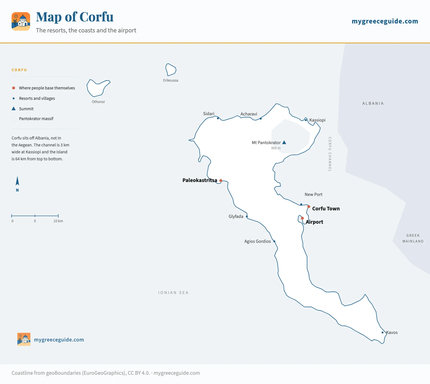
The island runs north to south for 64 km, with the town, the airport and the ferry port bunched together on the east side and almost nothing on the long southern tail until Kavos. The north coast has the sand, the west coast has the cliffs and the sunsets, and the interior is a green ridge that slows every drive down. Everything below is placed from its real coordinates.
The island
Where Corfu is, and why the position changes the island
Put Corfu on a map of Europe and it lands at the mouth of the Adriatic, level with the heel of Italy and tucked into the coast of Albania. It is 39.6 degrees north, roughly the latitude of Naples. On a map of Greece it occupies the top left corner, at the head of the Ionian chain that continues south through Paxos, Lefkada, Kefalonia and Zakynthos. Athens is 500 km away, on the far side of the Pindus mountains.
That chain is a line on a map and not a route. Each of these islands has its own way in, by air, by a mainland port or, in one case, over a bridge. The Ionian islands run about 200 km south from Corfu, but no single boat works its way down them: each one is reached from its own mainland port, so getting from here to Zante at the southern end means the ferry back to Igoumenitsa and then four hours of driving to Kyllini in the Peloponnese. Flying between them is not much better, because the strip in the middle of Kefalonia is the only other Ionian airport of any size and its links are with northern Europe rather than with Corfu. Two Ionian islands in one week works by car and boat, or not at all, and how big Kefalonia turns out to be is the thing that usually decides it.
You notice the first consequence within a day. Corfu takes about 1,100 mm of rain a year off the Adriatic and stays green into July, while the Cyclades have burnt brown by May. The second one takes a walk through the old town. Sitting on the sea route between Venice and the Levant put the island in Venetian hands for four centuries, which is where the olive groves and the tall shuttered streets came from. The Ottomans never took it, the only part of Greece where that is true, so what you walk through is Venetian, then French, then fifty years of British.
What the rain buys
It also decides how you arrive. There is no ferry from Piraeus. The crossings that matter come from Igoumenitsa on the mainland, 90 minutes away, and from Bari and Ancona in Italy. A passenger boat runs from Saranda in Albania in half an hour. If you are driving from Athens, you are looking at a motorway run to Igoumenitsa and then a ferry, not an island hop.
Corfu resorts map: where the resorts are, and who each one suits
Corfu sorts itself by coast rather than by distance. The north has the shallow sand, the west has the drama and the drives, the east is the built up commuter strip near the town, and the south tapers into a single road that ends at Kavos. Once you know your coast, the hotels worth booking on each one are listed with their exact village.
Set the kind of week and the coast changes
What kind of week is it?
You want sand rather than shingle, water that stays shallow a long way out, and dinner within walking distance of the room.
Acharavi
North coast, under Mount Pantokrator
- Airport
- 50 min
- Old town
- 45 min
Four kilometres of gently shelving sand, a single road of tavernas behind it, and the mountain as a backdrop. Nothing here is loud, which is the whole point.
Roda
North coast, 4 km west of Acharavi
- Airport
- 50 min
- Old town
- 45 min
The same north coast sand with a smaller centre and cheaper apartments. Quieter than Sidari and half an hour from it if you want the water park.
How long everything takes
These are driving times outside July and August, when the north coast road backs up behind the excursion coaches. Add a third in high season, and more on the day the big ferries land.
| From | To | Distance | Time | Worth knowing |
|---|---|---|---|---|
| On the island | ||||
| Airport | Corfu Town | 3 km | 10 min | Walkable in 40 min along the bay, or 15 € by taxi |
| Airport | Paleokastritsa | 28 km | 40 min | Straight across the island on the old main road |
| Airport | Acharavi | 39 km | 50 min | North coast road, slow behind the coaches in August |
| Airport | Kavos | 47 km | 1 h 05 | The transfer most people underestimate |
| Corfu Town | Glyfada | 15 km | 30 min | Over the ridge at Pelekas, then a steep descent |
| Corfu Town | Agios Gordios | 17 km | 30 min | Hairpins at the end, and no bus after early evening |
| Corfu Town | Kassiopi | 36 km | 50 min | The coast road under Pantokrator, with Albania alongside |
| Corfu Town | Sidari | 36 km | 50 min | Green bus roughly every two hours in summer |
| Sidari | Paleokastritsa | 27 km | 45 min | No coastal road between them, you cut inland |
| Getting to the island | ||||
| Igoumenitsa | Corfu new port | 24 km | 1 h 30 | Car ferry, hourly in summer. The fast boat does it in 1 h |
| Athens | Corfu | 500 km | 7 h | Motorway to Igoumenitsa, then the ferry. No direct ferry from Piraeus |
| Bari | Corfu | by sea | 8 h | Overnight sailing from Italy, mostly April to October |
| Ancona | Corfu | by sea | 15 h | The long Adriatic crossing, usually one sailing a day in summer |
| Saranda | Corfu | by sea | 30 min | Passenger hydrofoil from Albania, passport control both ends |
Corfu Town map: the ports, the fortresses and the old town
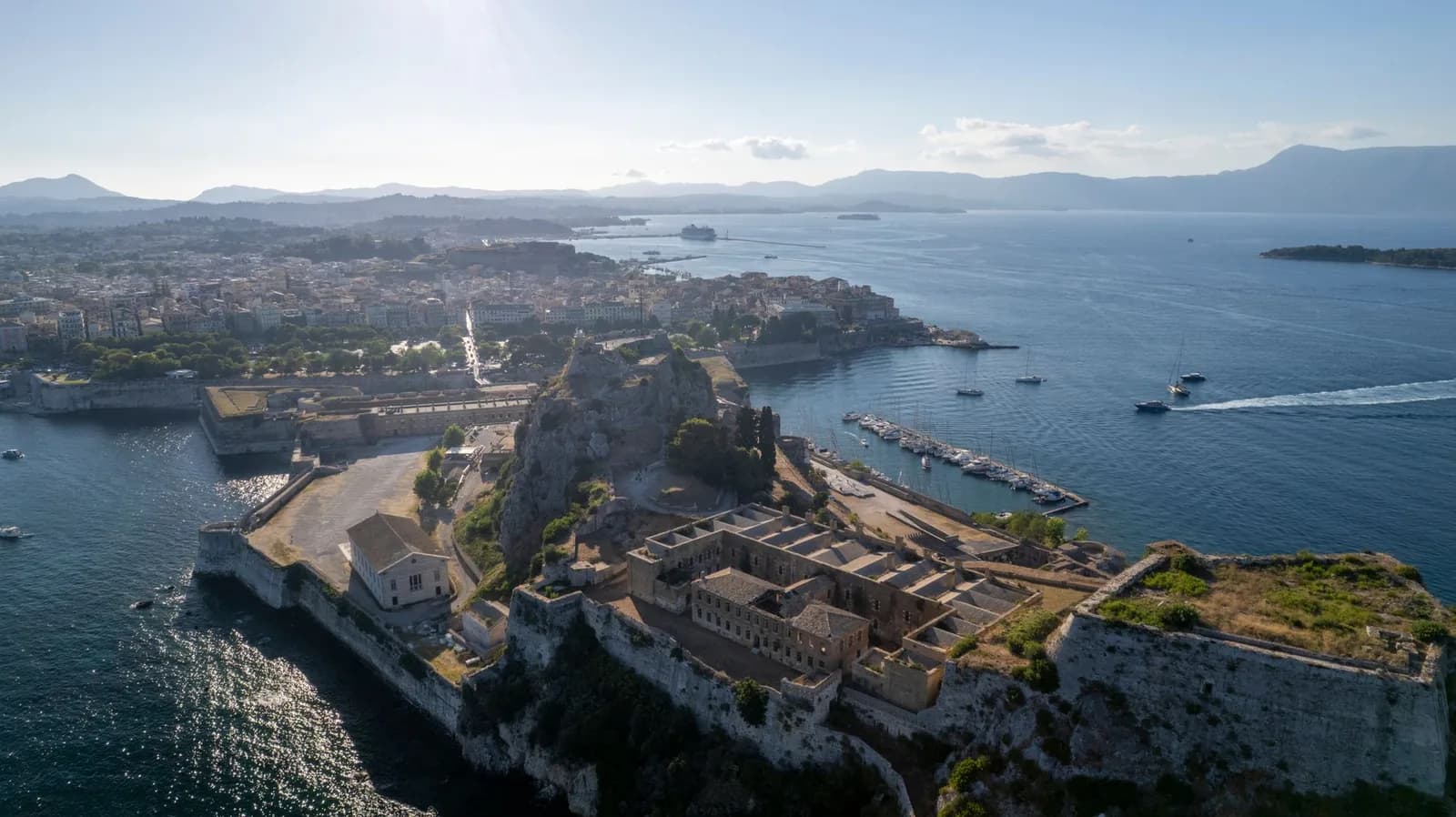
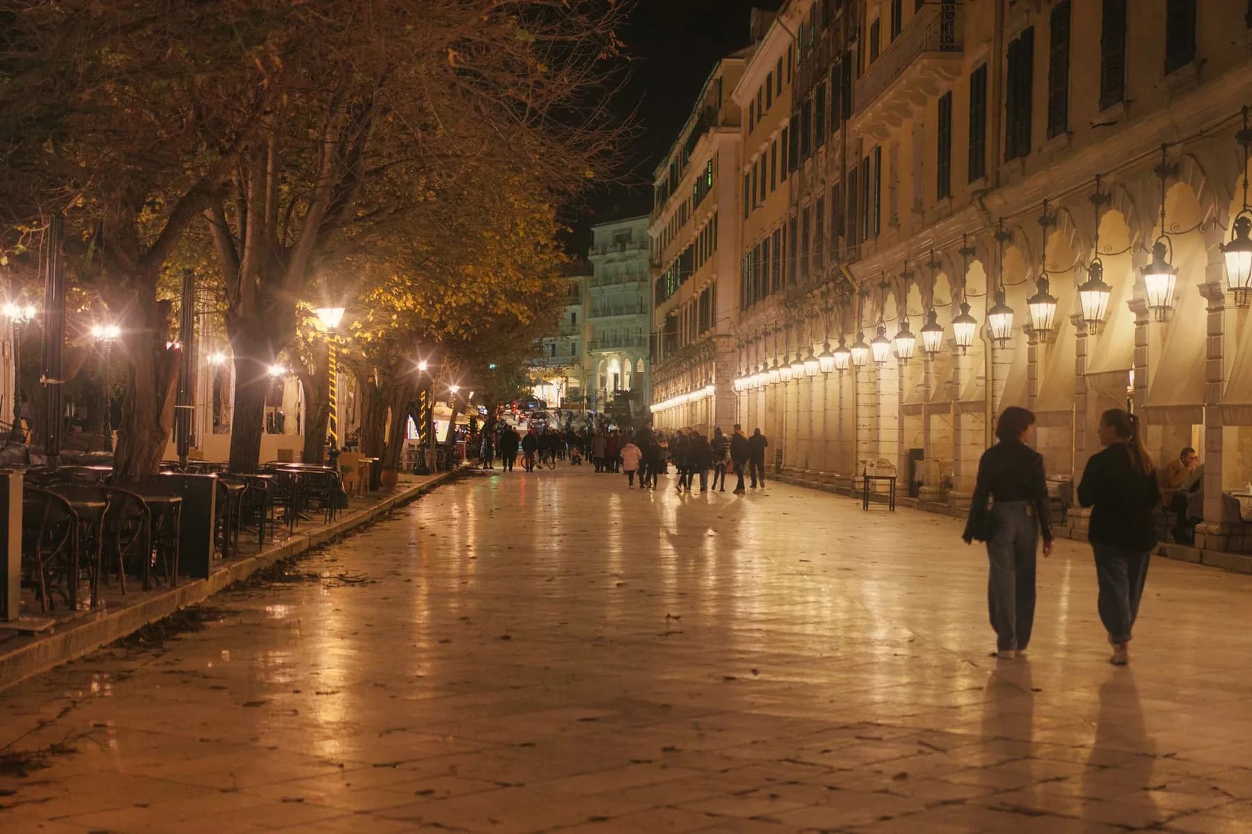
Corfu Town, or Kerkyra on Greek signage, is squeezed between two fortresses on a headland, and the whole old quarter is a UNESCO site. Orientation is easier than the lanes suggest. The Spianada, the huge green esplanade the British laid out for cricket, separates the old town from the Old Fortress on its islet. Along its western edge runs the Liston, the arcaded terrace of cafes where everyone ends up. Behind that, the Campiello lanes climb north through six storeys of shutters and washing lines until they drop out at the Old Port.
The town
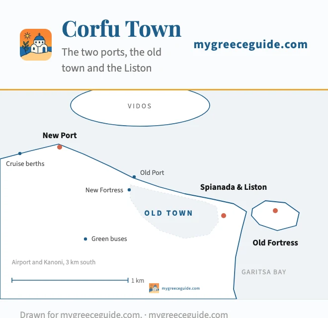
A schematic plan, not a survey: at this scale the Campiello lanes do not resolve. What is exact is where the pieces sit relative to each other. Ferries from Italy and Igoumenitsa dock at the new port, a 20 minute walk west of the old town. Cruise ships berth further out again, which is why the shuttle bus exists.
The two ports catch people out. The new port is where every car ferry and every crossing from Italy arrives, on the north-west shore, and it is a flat 20 minute walk into the old town or a short taxi. The old port, further east under the New Fortress, now handles small boats and the five minute crossing to Vidos, the wooded island that closes off the bay. Neither is the cruise terminal, which sits beyond the new port and runs its own shuttle.
The edge you navigate by
Getting around: bus or car
Two bus networks split the island and both are centred on Corfu Town. The blue buses cover the town and the near suburbs, out to Kanoni, Dassia, Benitses and the Achilleion, and they run often enough to use without planning. The green KTEL buses handle everywhere else, Paleokastritsa, Sidari, Acharavi, Kassiopi and Kavos, from the terminal near the new port. They are fine for a return trip in summer and thin out to two or three a day in the shoulder season, with almost nothing on Sundays.
The gap the buses leave is the west coast. There is no coastal road linking Paleokastritsa, Glyfada and Agios Gordios, so each one is reached by its own spur off the spine of the island, and getting between two of them by bus means going back through Corfu Town. If your week is anywhere on that side, take a car for at least part of it. If you are based in the town or on the blue bus line, you can skip it entirely and save the parking argument.
Questions people ask about Corfu
What country does Corfu belong to?
Greece. It has been Greek since 1864, when Britain handed the Ionian islands over, and it is the one part of the country the Ottomans never took. What confuses people is the map: the channel between the north-east tip and Albania is about 3 km wide, close enough to read the houses on the far shore from Kassiopi, while Athens is 500 km away on the other side of the Pindus mountains. Italy is 8 hours by overnight ferry from Bari.
Where are the nicest parts of Corfu?
The island sorts by coast rather than by distance. The west, at Paleokastritsa and Agios Gordios, has the cliffs, the coves and the sunsets, and it is the prettiest half. The north, around Acharavi and Roda, has the shallow sand and the family resorts. The north-east, from Nissaki up to Kassiopi, is the quiet olive and cypress coast with the Albanian mountains opposite. Corfu Town itself, if you would rather walk a Venetian old quarter than drive to a beach. Kavos in the far south is the nightlife strip and nothing else.
Where are the best beaches on Corfu?
Depends which kind. For sand you can walk into, the north coast: Acharavi, Roda and Agios Georgios in the north-west are long, shallow and shelve gently. For scenery, the west coast, where Paleokastritsa is a set of six small coves under cliffs and Porto Timoni near Afionas is a double bay reached on foot in twenty minutes. Canal d'Amour at Sidari is the sandstone one everyone photographs. Note that the west coast beaches are each reached by their own spur road off the middle of the island, not by a coast road.
Which is better, Corfu or Crete?
They are not the same kind of holiday. Corfu is 64 km long, green, wet enough at around 1,100 mm of rain a year to stay that way into July, Venetian in its architecture, and small enough to drive end to end in an hour and a quarter. Crete is 260 km long, four and a quarter hours from one end to the other, drier, with mountains above 2,400 m, Minoan palaces and a much longer swimming season. Choose Corfu for a one-base week and old town evenings, Crete if you want a road trip and archaeology.
Why is Corfu famous?
For the old town, which is a UNESCO site and reads as Venetian rather than Greek, with two fortresses, the arcaded Liston the French built and the Spianada the British laid out for cricket. For the Durrells, whose 1930s years at Kalami and Kontokali became My Family and Other Animals and then the television series. For the Achilleion, the palace Empress Elisabeth of Austria built above Gastouri. And for being green: three million olive trees planted under Venetian rule, on an island that looks nothing like the Cyclades.
What is there to see in Corfu Old Town?
It is small enough to cover in an afternoon and layered enough to spend two days on. The Spianada, the biggest square in Greece, splits the old town from the Old Fortress on its islet. The Liston runs down its western edge. Behind it the Campiello lanes climb north through six storeys of shutters until they come out at the old port. Add the Church of Saint Spyridon with the island's patron saint in a silver casket, the New Fortress above the port, and the Asian art museum in the old British palace at the north end of the Spianada.
