Zakynthos map: where everything is on Zante
The island in the photograph and the island most people book are on opposite coasts. Zakynthos has a flat, sandy, thoroughly built east side and a cliff wall down the west, and no road crosses from one to the other.
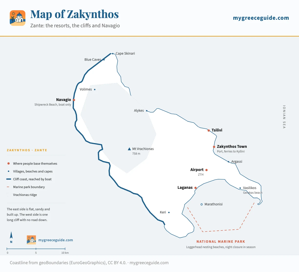
Zakynthos runs 40 km from Cape Skinari down to the Vasilikos peninsula, and it is split almost cleanly in half. The town, the port, the airport and every resort sit on the eastern and southern side. The western side is one long cliff, and the two things the island is famous for, Navagio and the Blue Caves, are both on that cliff. Everything below is placed from its real coordinates.
It is the southernmost of the Ionian islands, the green chain down the west side of Greece that has nothing to do with the Cyclades most people picture, and the chains are worth separating out first if you are still deciding which part of the country you are going to.
The island
Zakynthos or Zante, and the two coasts behind the name
Both names belong to the same island. Zakynthos is the Greek one, on the road signs and the ferry timetables. Zante is the Italian form the Venetians left behind, and it is what most British and Irish operators still print on a booking. You will see the two alternate inside a single brochure, which is confusing the first time and harmless after that.
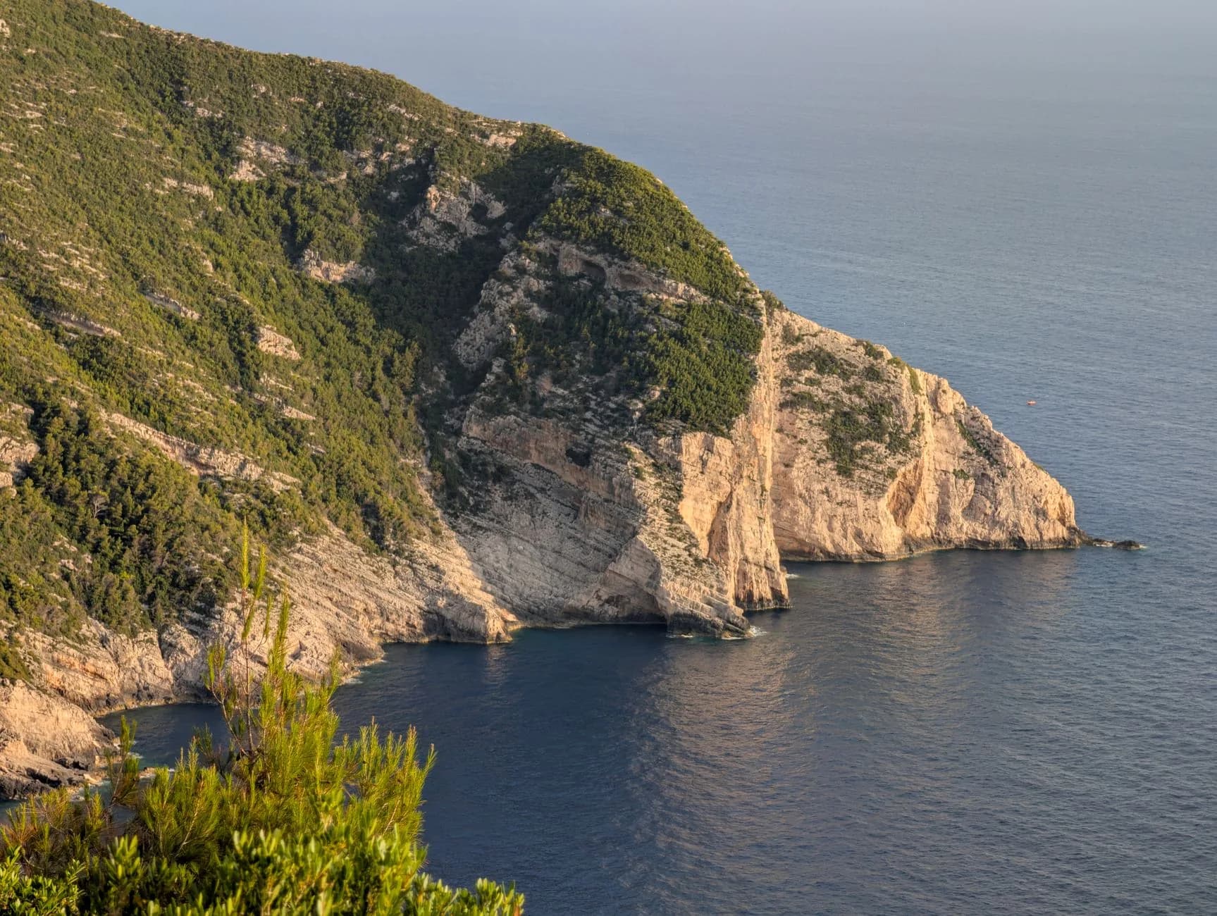
The split that actually matters is geographic. Everything east of the Vrachionas ridge is low, farmed and edged with sand: Tsilivi, Alykes, Argassi, Laganas, the currant plain around the airport. It holds the hotels because it is the only part of the island where hotels are possible. West of the ridge the land stops in a wall three hundred metres above the sea, from the northern tip almost to Keri, broken by a handful of coves that you reach in a boat or not at all.
The wall
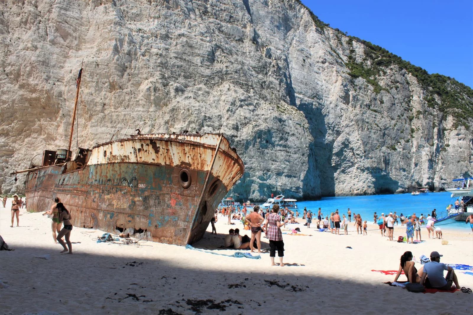
That is why the booking goes wrong so often. Somebody sees the wreck on the sand between two white cliffs, books a week in Laganas because it is cheap and close to the airport, and finds out on arrival that the cove in the photograph is 44 km away and only reachable by sea. Neither fact appears on a hotel listing.
The same one-sided pattern turns up further north in the chain, though the geography is gentler about it. Corfu also puts its resorts on one coast and its cliffs on the other, but it has roads over the top and a town worth a day in its own right, so the layout up there is worth comparing if you are choosing between the two islands rather than visiting both. Kefalonia sits directly between them, close enough that a fair number of people fly into it and finish the trip here, and landing at EFL instead is often the cheaper half of a two-island week, with the ferry from Pesada down to Agios Nikolaos closing the gap in about ninety minutes. It is a far larger island than this one, though, and seeing how its villages are spread out is worth doing before you split a week between the two.
Where the resorts are, and who each one suits
The resorts sit in a rough arc from Alykes in the north-east, past the town, round to Laganas Bay and out along the Vasilikos peninsula. They are close together by Greek island standards, and the gap between Laganas and anywhere else is far wider than the eight kilometres suggest. The hotels in each one, and what each is like after dark, are in our guide to where to stay in Zakynthos.
Pick who is travelling and the resorts follow
Who is the trip for?
You want shallow sand, a short transfer and a strip you can walk at night without crossing a main road.
Tsilivi
East coast, 5 km north of Zakynthos Town
- Airport
- 20 min
- Town
- 10 min
A flat blue-flag beach, a waterpark behind it and one long street of tavernas and mini markets. The most straightforward family base on the island, and the easiest to reach without a car.
Alykes
North-east coast, 16 km from the town
- Airport
- 35 min
- Town
- 25 min
The same shallow water with a fraction of the traffic, plus salt pans and a small harbour. Further from everything, which is the trade you are making.
The usual mistakeLaganas ticks the sand and the transfer, then keeps a thousand people awake until four in the morning.
How long everything takes
These are driving times outside July and August. In high season add a third on the town ring road, and more on the north-west route to the Navagio viewpoint, where the last stretch is single track and the coaches turn round at the top.
| From | To | Distance | Time | Worth knowing |
|---|---|---|---|---|
| Airport | Laganas | 8 km | 10 min | Closest resort to the runway, and under the approach |
| Airport | Zakynthos Town | 6 km | 10 min | The airport bus reaches the bus station here, and nowhere else |
| Airport | Tsilivi | 11 km | 20 min | Through the town, slow in the afternoon |
| Airport | Alykes | 24 km | 35 min | The longest family transfer on the island |
| Airport | Vasilikos | 20 km | 30 min | One road down the peninsula, no bus after 3 pm |
| Zakynthos Town | Limni Keriou | 17 km | 30 min | Boats to the Keri caves and Marathonisi |
| Zakynthos Town | Cape Skinari | 32 km | 55 min | Where the small boats into the Blue Caves start |
| Zakynthos Town | Navagio viewpoint | 36 km | 1 h | The clifftop platform, not the beach |
| Laganas | Navagio viewpoint | 44 km | 1 h 15 | Both ends of the island in one drive |
| Porto Vromi | Navagio beach | by sea | 20 min | By boat. There is no other way onto the sand |
Navagio and the Blue Caves: what the map cannot tell you
Navagio is a cove on the north-west coast with a rusting coaster, the Panagiotis, sitting on the sand where it was driven ashore in 1980. There is no path down and there never has been. Boats run from Porto Vromi, twenty minutes away, from Cape Skinari at the northern tip and from Agios Nikolaos, plus longer day trips out of Zakynthos Town and Laganas. The cliff above the sand has been dropping rock, and landings have been suspended more than once since 2018.
The viewpoint above the cove is a completely separate journey. It is an hour by road from the town, through Anafonitria, and the platform hangs over the drop with the beach a long way below. Sections of that clifftop have been fenced off after landslides, so the arrangement changes from one season to the next. Treat the viewpoint and the beach as two different outings rather than two views of the same one.
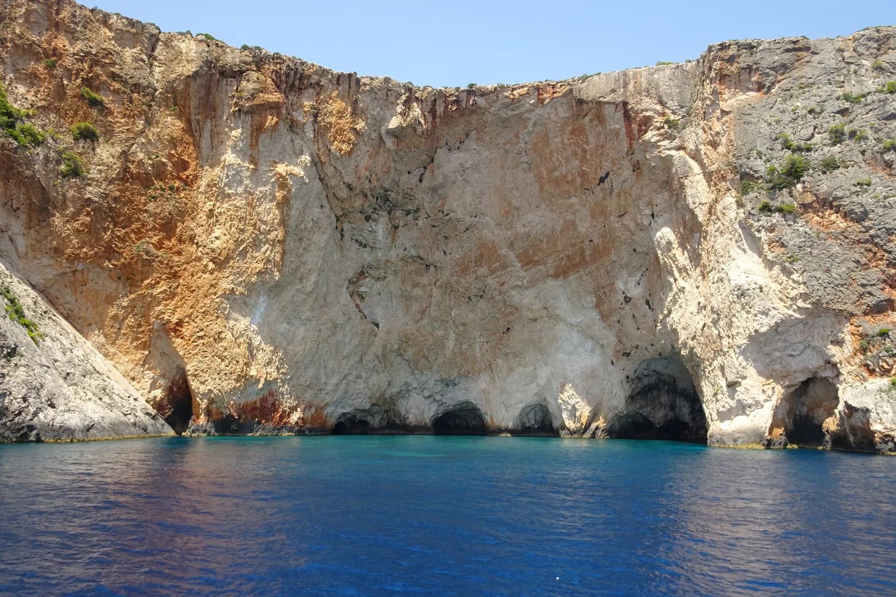
The Blue Caves are 12 km further north, arches and hollows in the same limestone where the water throws blue light back onto the rock. Small boats go in from Agios Nikolaos and Cape Skinari, and the light is best before eleven. Most operators sell the caves and the wreck as one trip.
Where the caves are
Laganas Bay is a national marine park
The whole southern bay, from the Keri cliffs round to Gerakas, is the National Marine Park of Zakynthos, and it exists for one reason: these beaches carry the densest loggerhead turtle nesting anywhere in the Mediterranean. Sekania, a small strand you cannot land on, takes the largest share of nests. Dafni, Gerakas, Kalamaki and the eastern end of Laganas take the rest.
The practical consequences show up on your holiday. Nesting beaches close between sunset and sunrise from late May to the end of October, umbrellas are restricted to marked strips or banned above the high water line, and lights facing the sand are not allowed because hatchlings navigate by the horizon. On the water there are speed limits, anchoring bans and a no-go zone off Sekania, which is why turtle-spotting boats out of Limni Keriou and Laganas run to a fixed route rather than wherever they like.
The rules are posted in English at every beach entrance, and a room on Laganas beach is a room inside a protected area. If seeing a turtle is part of the trip, Limni Keriou and the Vasilikos side put you closest to it.
Getting around: bus or car
One KTEL network covers the island and every line starts from the terminal in Zakynthos Town. Laganas, Tsilivi, Argassi, Kalamaki and Alykes get a decent service in July and August, several buses a day and a late one on the Laganas route. Everywhere else thins out to one or two departures and nothing on Sunday. The airport has a service of its own, nine a day into the same terminal in town, but it stops in the early evening and does not run on Sunday, which is why most arrivals at Zante airport come down to a taxi or a pre-booked car whatever your budget.
The bus will not take you to the north-west. Volimes, Anafonitria, the Navagio viewpoint, Porto Vromi and Cape Skinari are car territory, and so is the Vasilikos road after mid afternoon. If your week is Tsilivi or Laganas plus two boat trips, skip the car entirely. If the west coast, the mountain villages or Gerakas are on your list, hire for those days and hand it back, rather than paying for a week of it sitting outside the hotel.
Questions people ask about Zakynthos
Where is Zakynthos located in Greece?
Off the west coast, not in the Aegean where most people look for it. Zakynthos is the southernmost of the seven main Ionian islands, sitting about 16 km out from the western Peloponnese and roughly 300 km from Athens by road and boat. Kefalonia is its neighbour to the north, Corfu is 200 km further up the same chain. The island runs 40 km from Cape Skinari down to the Vasilikos peninsula and about 20 km across, which is an hour and a quarter end to end by car. In summer flights land at ZTH direct from across Europe; out of season the way in is the ferry from Kyllini, an hour and a quarter into Zakynthos Town.
Which part of Zakynthos is best?
The east and south coasts, because they are the only ones with resorts on them. Tsilivi and Alykes suit families, Laganas and Argassi have the bars, the Vasilikos peninsula and Limni Keriou are the quiet end with the best scenery, and Zakynthos Town is the one base that works without a car. The west coast has nothing at all: it is unbroken cliff from Cape Skinari down to Keri, which is why every famous photograph of this island is taken from a boat rather than from a hotel balcony.
What is Zakynthos, Greece famous for?
Navagio, the Shipwreck Beach, above everything else. It is a cove on the north-west cliff with a rusted freighter half buried in the sand, and it is closed on three sides by rock, so there is no path down and no way to reach it except by boat, about twenty minutes from Porto Vromi. Second is the loggerhead turtles: Laganas Bay is the National Marine Park and holds the densest nesting in the Mediterranean, with the sand at Sekania, Dafni and Gerakas closed between sunset and sunrise from late May to October. Third are the Blue Caves at the northern tip, and the fact that the whole island still gets called Zante by British tour operators.
Which island is better, Corfu or Zakynthos?
Corfu if you want a town and a landscape, Zakynthos if you want the boat trips. Corfu is around 40 percent larger, greener, and has a Venetian old town that is a UNESCO site and worth two or three days on its own, with roads that actually cross the island. Zakynthos is smaller, drier, cheaper in the resorts, and organised around two things you take a boat to see. Zakynthos also has the harder rain shadow in shoulder season, and Corfu is easier to reach out of summer because the ferry from Igoumenitsa runs all year.
Where is Zakynthos airport on the map?
Just south of Zakynthos Town, on the flat ground between the town and Laganas Bay, which makes it the shortest transfer of any Greek island airport. Laganas is 8 km away, about ten minutes, and the approach passes over the eastern end of the resort. Zakynthos Town is 6 km, Tsilivi 12 km, and Vasilikos at the far south-east about 20 km. There is no airport bus at all, so it is a taxi or a pre-booked minibus, around 20 euros to either Laganas or the town.
Where are the best beaches in Zakynthos, on the map?
Gerakas and Dafni on the Vasilikos peninsula are the pick for sand, both inside the marine park and both closed after dark in nesting season, with no umbrellas allowed on parts of Gerakas. Porto Zoro and Banana are the busier versions of the same coast. Tsilivi and Alykes on the east are shallow, safe and built up. Xigia, on the north-east, is a small sulphur cove that smells of it. Navagio and the Blue Caves are on the west cliff and are boat trips rather than beaches you spend a day on.
