Milos map: the beaches, the boats and Kleftiko
On Milos the question is not where a beach is, it is whether anything can get you to it. Some have a car park, one has a rope and a wooden ladder, and the most famous of them has no road within several kilometres. One map settles all three.
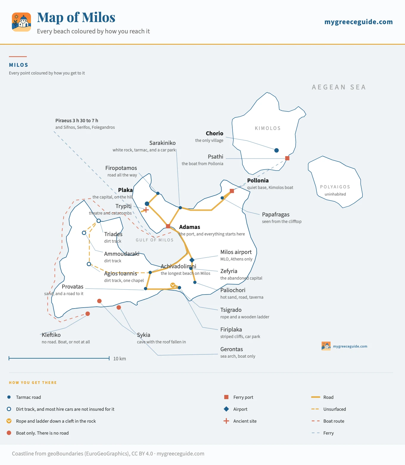
Milos is a volcano whose crater flooded, which is why it is shaped like a hand cupped round an enormous bay, and why every road on the island radiates from the one port at the head of it. Sarakiniko has tarmac and a car park. Tsigrado has a rope. Kleftiko has nothing at all, and never will. The map below colours every place by which of those it is.
That is the thing to fix before anything else, because it is what separates Milos from Naxos and Paros, where a hire car and a morning will get you anywhere. Here about a quarter of the coast is off the road network entirely.
The island, by access
The four ways you reach a beach on Milos
Milos has somewhere around seventy beaches, which is an absurd number for an island of this size, and the guides list them by coast. That is the least useful way to sort them. The gap that ruins a day here is not the twenty minutes between two bays. It is the gap between a beach with a car park and a beach with no road within four kilometres, and those two are regularly next door to each other.
So the list below is sorted on that axis instead, in four rungs, from the ones you reach without thinking about it to the ones that need a boat and a whole day. The marks are the same four that are on the map.
The four marks below are the same four you will find on the map, and they say the only thing that decides a day on Milos: whether a road goes there. The list runs from the beaches you can reach in a hire car with no thought at all to the ones with no road within several kilometres, so you can stop at the rung that matches the holiday you want.
A road goes there
Any car, and for some of them a bus
Tarmac to a car park, and you walk from it. This is most of the north coast and most of the south, and it is the half of Milos that works without planning anything.
- SarakinikoNorth coast, 5 km from Adamas
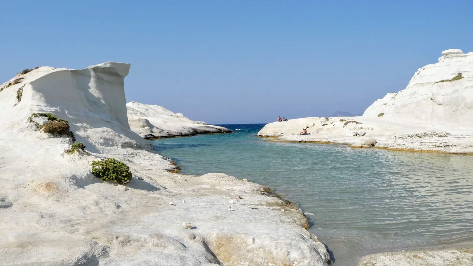
- The one every photograph of Milos is of, and the easiest thing on the island to reach. White volcanic rock scoured into ridges and hollows, with almost no sand and no shade whatsoever. It is free, it is signposted, and the car park is full by ten. Early morning and the last two hours of light are a different place entirely.
- PolloniaNorth-east corner, 12 km
- A working fishing village that turned into the island's second base, with tamarisk trees along a shallow beach and the boat to Kimolos leaving from the end of it. Quieter than Adamas at night and better for eating.
- FiropotamosNorth coast, 6 km
- A small cove with a white chapel on the headland and a row of boat garages cut into the rock at the waterline. The road runs to the top of it and the last stretch down is steep but surfaced.
- PaliochoriSouth coast, 11 km
- Milos is a volcano and this is where you feel it. The sand is genuinely hot in patches, hot water seeps out at the shoreline, and a taverna at the back cooks in the ground. Sunbeds, a road and a decent car park.
- FiriplakaSouth coast, 12 km
- Long, with cliffs behind it striped in white, pink and rust. It sits round the headland from Tsigrado and is what most people do instead once they have looked over the edge at the ladder.
- Provatas and AchivadolimniSouth and south-west, 8 to 10 km
- The two easy sandy ones. Provatas is small and sheltered, Achivadolimni is the longest beach on Milos, backed by a salt lake and the island's campsite, and it never feels busy because there is simply a lot of it.
The tarmac runs out
High clearance, or a quad. Read the hire agreement first
The whole west of Milos is like this. The surface ends several kilometres short and what follows is graded dirt, sometimes with a rocky last stretch. It is not dangerous, it is uninsured, which is a different problem.
- Agios IoannisWest coast
- A chapel, a bay and nothing else, at the end of a track running west from the middle of the island. People go for the sunset and because they will have it to themselves.
- TriadesNorth-west
- Three coves of pale sand facing west into open sea. Among the emptiest beaches in the Cyclades, and the reason is the last four kilometres of the road.
- AmmoudarakiWest coast
- Further down the same coast, reached the same way. There is no water, no shade and nowhere to buy anything, so this is a day you pack for.
You climb down
One beach on Milos, and it is not for everyone
There is exactly one of these, and it is why the island has a reputation for being awkward. Nothing else on Milos asks this of you.
- TsigradoSouth coast, 12 km from Adamas
- You drive to a scrap of clifftop car park, walk to what looks like a dead end, and find a cleft in the rock going down. Inside it there is a rope and a wooden ladder, and the descent is a few metres of squeezing through a chimney with people coming the other way. At the bottom is a small cove of pale sand between two walls of rock, and it is genuinely lovely. It is also unmanaged: nobody maintains the ladder, there is no other exit, and it is a poor idea with small children, a bad shoulder or anything you cannot carry one-handed. Firiplaka is round the corner with a car park and a bar, and there is no shame in that being the answer.
No road exists
A boat, and a day given over to it
The entire south-west of Milos has no road of any kind. These places are not hard to drive to, they are undriveable, and every photograph you have seen of them was taken from the water.
- KleftikoSouth-west corner
- White rock stacks and arches standing out of very clear water, with caves cut through them at sea level. Pirates used it because nothing on land overlooks it, and that is still true: there is no viewpoint, no path and no way to walk in. Boats from Adamas take a couple of hours to get round, which is why it is a full day rather than an afternoon.
- SykiaWest coast
- A sea cave whose roof collapsed, so it is a room of rock open to the sky with a beach of sand at the back of it and a shaft of light coming down. Boats go in through the mouth when the sea is flat enough.
- GerontasSouth-west
- A natural arch with water running under it, usually the last stop before a boat turns for home. Small, and it is on the itinerary for the arch rather than for swimming.
Sarakiniko, and the coast either side of it
Sarakiniko is the reason most people look up Milos in the first place, and it is worth being clear about what it actually is, because the photographs mislead. It is not a beach. It is a headland of white volcanic rock, pumice and ash compacted and then scoured by weather into smooth ridges, bowls and overhangs, with a narrow inlet cut into the middle of it where the sea comes in. There is a small strip of sand at the head of that inlet and that is all of it.
Everything else follows from the rock. There is no shade of any kind, the white surface throws the afternoon back up at you, and the stone gets hot enough that people wear something on their feet. It is free and it is five kilometres from the port, which is the whole problem: by mid-morning in August the car park has spilled onto the verge and the ridges are full of people photographing each other. Go at first light or in the last two hours before sunset and you get a different place for the same drive.
The coves the road does reach
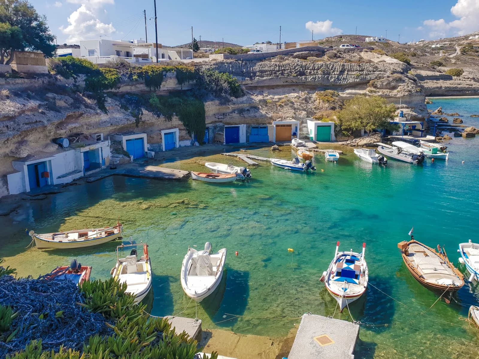
The rest of the north coast is a run of small coves on short surfaced spurs off the same road. Firopotamos has a chapel on the headland and boat garages at the water, Mandrakia is the same idea one bay along, and Papafragas is a set of very narrow inlets between white cliffs. Papafragas is looked at from above rather than swum in: the scramble down has been unstable for years and is roped off at times, so treat the clifftop as the destination.
Kleftiko, and why no road will ever go there
Kleftiko is a cluster of white rock stacks standing out of very clear water at the south-western corner of the island, with arches and caves cut through them at sea level. It is the image Milos sells itself on and it is on the map here as a terracotta dot, because there is no road, no track, no footpath and no viewpoint over it. The name comes from kleftis, thief: it was a pirate anchorage, and it worked because nothing on land overlooks the bay. Twelve centuries later that is still the operative fact.
So the practical shape of a visit is set by the sailing, not by the site. From Adamas it is roughly two hours each way, out through the mouth of the gulf and down the entire west coast, which is why every trip is a full day and why most of them take in Sykia and Gerontas on the way. Boats from the south coast are closer and quicker. The other constraint is wind: a strong meltemi cancels the sailing outright, and that happens often enough through July and August that booking it for the last day of a stay is a mistake people make repeatedly.
Plaka, Trypiti and the mile and a half down to Klima
The other thing the island map flattens is the hillside above the gulf, and it is the one part of Milos where walking beats driving. Four of the things people come to Milos for are stacked on a single slope, within about a mile and a half of each other, and most visitors drive up to them separately across three different days.
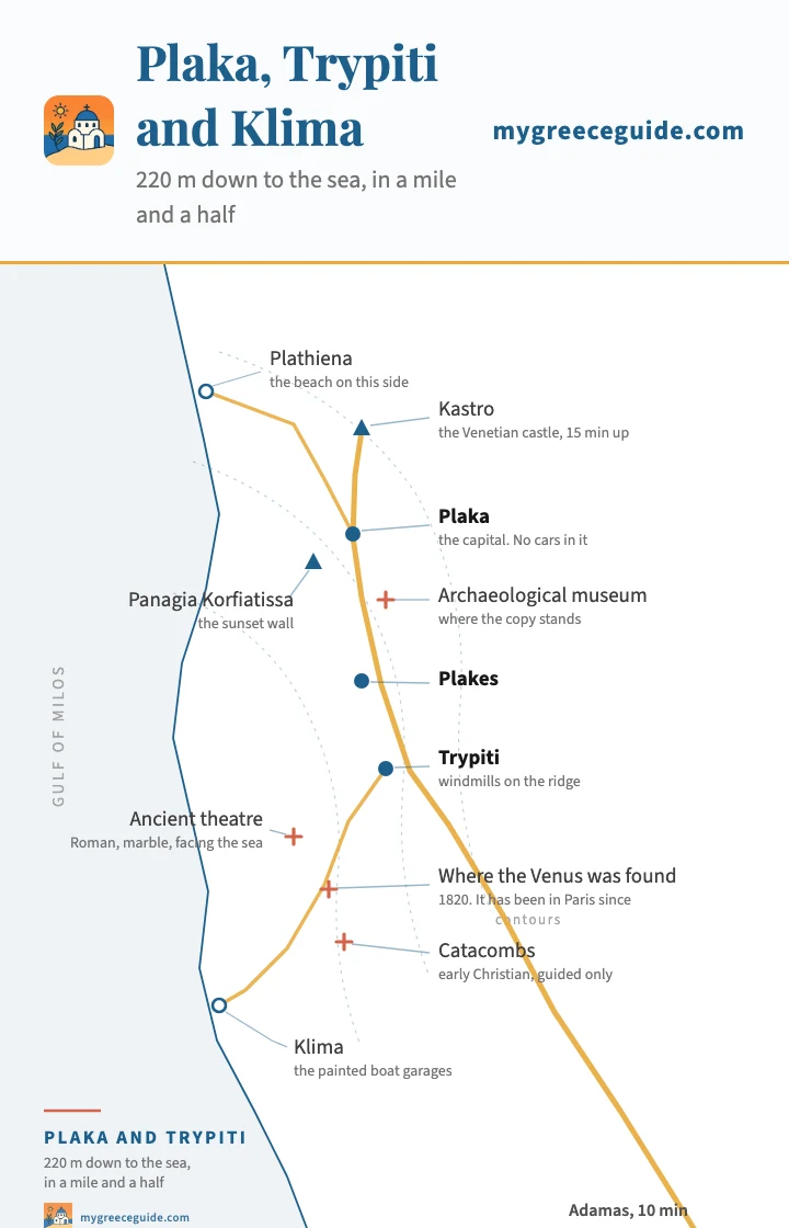
220 m down to the sea
A schematic plan: the positions are right, the shoreline is drawn rather than surveyed. The faint arcs are contours, and they are the point. Everything here hangs off one slope, so the sensible move is to park once below Plaka and walk down, not to drive up three times. The theatre, the catacombs and the spot where the Venus was found are within five minutes of each other under Trypiti. What the contours also tell you is that the walk back up from Klima at the end of a hot afternoon is a real climb.
At the top is the Kastro, the Venetian castle on the summit of the ridge, about fifteen minutes up through the lanes and the standard place to be at sunset. Plaka itself is the capital and takes no cars at all, so you leave one below it and walk in. The church of Panagia Korfiatissa sits on a wall on the seaward edge with the whole gulf underneath it.
Below Trypiti the slope carries three things worth the descent. The Roman theatre is cut into the hill in white marble and faces straight out to sea, which is a considerably better view than the seats were built for. The catacombs, a few minutes further, are the most significant early Christian burial complex in Greece and are visited on a short guided circuit rather than wandered through. And between them is the marked field where a farmer turned up the Venus de Milo in 1820. The statue has been in the Louvre since 1821, and the museum in Plaka has the cast.
The bottom of the hill
How long everything actually takes
Every figure below runs from Adamas, because on this island everything does. The column that matters is not the distance, it is what the last kilometre is made of.
| From Adamas to | Distance | Time | What happens when you get there |
|---|---|---|---|
| North and east, on tarmac | |||
| Plaka and Trypiti | 4.5 km | 10 min | Park below the village and walk up. The lanes at the top take no cars at all |
| Klima | 6 km | 15 min | Down a steep surfaced spur from Trypiti. There is very little room to leave a car at the bottom |
| Sarakiniko | 5 km | 10 min | Signposted, free, and the car park overflows onto the verge from mid-morning |
| Firopotamos | 6 km | 15 min | The last descent is steep but surfaced the whole way |
| Papafragas | 10 km | 18 min | The inlets are looked at from the clifftop. The scramble down has been unstable and is roped off at times |
| Pollonia | 12 km | 20 min | The second base on the island, and where the Kimolos boat goes from |
| South, on tarmac | |||
| Milos airport | 5 km | 10 min | Domestic only, small propeller aircraft, and about 40 minutes from Athens |
| Achivadolimni | 8 km | 15 min | The longest beach on Milos, with the salt lake and the campsite behind it |
| Provatas | 9 km | 18 min | Small, sheltered, sandy, and the least demanding beach on the south coast |
| Paliochori | 11 km | 20 min | Hot sand in patches, and hot water seeping out where the sea meets it |
| Firiplaka | 12 km | 22 min | Striped cliffs, a proper car park, and the practical answer to Tsigrado |
| Tsigrado | 12 km | 22 min | The drive is the easy part. What follows is a rope and a wooden ladder down a cleft |
| West, where the surface ends | |||
| Triades | 14 km | 40 min | Roughly the last 4 km are dirt. Most hire agreements exclude unsurfaced roads |
| Ammoudaraki | 16 km | 45 min | No water, no shade, nothing to buy. Bring the day with you |
| Agios Ioannis | 15 km | 45 min | A chapel and a bay. People come for the sunset and stay for it |
| By boat, because there is no alternative | |||
| Kleftiko | no road | a full day | Two hours or so each way from Adamas under power, less on a fast boat from the south coast |
| Sykia and Gerontas | no road | on the same trip | Both are stops on the west coast run rather than destinations of their own |
| Kimolos | from Pollonia | about 20 min | A small local ferry across the strait, several a day in season and thin outside it |
| Piraeus | Athens | 3 h 30 to 7 h | High-speed or conventional. The slow ships call at Sifnos and Serifos on the way |
| Santorini | Cyclades | 2 h to 3 h | High-speed only, and not every day outside high summer |
Every distance here is measured from Adamas, because on Milos everything is. There is no ring road and no second hub: the network is a star, and going from one beach to another almost always means passing back through the middle. What the time column is really recording is the surface. Twelve kilometres to Firiplaka takes twenty two minutes and fourteen to Triades takes forty, and the four kilometres of dirt at the end are the whole of the difference. Bus frequencies are deliberately absent: the KTEL timetable is rewritten every season and thins sharply either side of July and August.
The two rows to compare are Firiplaka and Triades. Twelve kilometres and twenty two minutes against fourteen kilometres and forty. The extra two kilometres are not the reason. The four kilometres of dirt at the end of the second one are.
Bus, car or quad
There is a bus network and it is better than people expect, but its shape is the shape of the map. Everything runs out of Adamas and back, so it is a star with one hub, and almost nothing goes beach to beach. Plaka, Pollonia, Paliochori, Provatas, Achivadolimni and the airport are all on it. Sarakiniko is on it seasonally. The west is not on it at all. Frequencies thin hard either side of July and August, which is when a bus-only plan quietly stops working.
Most people hire something, and the honest split is that a small car does nine tenths of the island and a quad or a high-clearance vehicle does the last tenth. The clause that catches people out is the unsurfaced road exclusion, because the west of Milos is exactly what it excludes, and the west is usually the reason someone wanted a vehicle in the first place. Read it before you decide Triades is the plan. If you would rather not drive at all, the answer is to base yourself where the walking is: where you sleep on Milos changes what you can do without a key more than it does on most Greek islands.
The west, the mines, and why the roads are like this
Everything above deals with the part of Milos that has a surface. The western third is a different island, and the reason is not neglect. Milos is still a working mining island, one of the largest producers of bentonite and perlite in Europe, and it has been quarried since the Neolithic, when its obsidian was traded across the Aegean. The road network was laid out to move rock to a jetty, not to move visitors to a beach, and it shows: wide graded tracks that go where the minerals are and stop.
What you get in exchange for the last four kilometres is the emptiest coast in this part of the Cyclades. Triades is three coves of pale sand facing open sea with nothing built on them. Ammoudaraki is further down the same shore, and Agios Ioannis has a chapel and a bay and no other structure at all. There is no water, no shade and nowhere to buy anything at any of the three, so these are days you pack for rather than days you decide on at eleven o'clock.
Arriving, and the island across the strait
Everything arrives at Adamas. There is one ferry port on Milos and it is at the head of the gulf, which is the entire reason the town exists: the flooded crater makes one of the best natural harbours in the Mediterranean, deep and sheltered from every direction but the north-west. The crossing from Piraeus is about three and a half hours on a high-speed boat and up to seven on a conventional ship, which calls at Serifos and Sifnos on the way and costs a good deal less. The airport takes propeller flights from Athens and nothing else.
Going on, Milos sits on the western line rather than the busy central one, which is worth knowing before you plan a route. Kimolos is the easy addition: a small local ferry crosses the strait from Pollonia in about twenty minutes, several times a day in season, and it lands you on an island with one village and almost no cars. Polyaigos, the large uninhabited island beyond it, is a boat trip and nothing else. Santorini is two to three hours east on a fast boat. If you are still working out which islands to string together, how the Cyclades connect to each other is the thing to look at before the individual island guides, and the map of the whole group shows why Milos is an awkward hop from Mykonos and an easy one from Folegandros.
Questions people ask about the map of Milos
Where is Milos on the map of Greece?
At the south-western corner of the Cyclades, in the Aegean, about 120 kilometres south-east of Athens. Sifnos and Serifos are the islands to the north on the same ferry line, Folegandros and Santorini lie east, and Kimolos sits across a strait barely a kilometre wide off the north-east tip. From Piraeus the crossing is around three and a half hours on a high-speed boat and up to seven on a conventional ship. There is also a small airport with propeller flights from Athens taking about forty minutes.
How do you get to Kleftiko on Milos?
By boat, and there is no second answer. Kleftiko is at the south-western corner of the island and no road of any kind goes near it, no path leads down to it and there is no clifftop viewpoint over it. That is precisely why pirates used it. Boats leave from Adamas and from the south coast, and from Adamas it is roughly two hours of sailing each way, which is why the trip takes a whole day rather than a morning. A strong meltemi will cancel the sailing outright, so it is worth booking it early in a stay rather than on the last available day.
Do you need a car on Milos?
For most of the island, yes. There is a bus network and it runs out of Adamas to Plaka, Pollonia, the southern beaches and the airport, but it is a star with a single hub, the frequency thins sharply outside July and August, and going from one beach to another usually means returning to the middle first. The bigger issue is the west, where the surface simply ends: Triades, Ammoudaraki and Agios Ioannis are at the end of dirt tracks that most hire agreements explicitly exclude. Milos is also a working mining island, so the road network was built for lorries rather than for visitors.
How do you get down to Tsigrado beach?
Through a cleft in the rock, on a rope and a wooden ladder. You drive to a small patch of clifftop, walk to what looks like the end, and find a gap going down. The descent is a few metres of squeezing through a rock chimney, often with people coming up the other way, and it opens onto a small cove of pale sand. Nobody maintains the ladder and there is no other way out. It is a bad idea with small children, with anything you cannot carry one-handed, or with a shoulder or knee that already complains. Firiplaka is round the headland with a car park and a bar.
What is Sarakiniko and how do you get there?
A stretch of white volcanic rock on the north coast, scoured smooth by wind and sea into ridges, hollows and a narrow inlet, with almost no sand and no shade at all. It looks nothing like the rest of Greece, which is why it is on every photograph of Milos. It is also the easiest place on this list to reach: five kilometres from Adamas, signposted, on tarmac, free to enter, with a car park that overflows onto the verge well before midday. Go at first light or in the last two hours before sunset and it is a genuinely different place.
Where should you stay on Milos?
Adamas if the ferry, the car hire desks and the boat trips matter most, since all of them start there and it is the middle of the star. Pollonia if you would rather eat well and swim before breakfast, twenty minutes north-east, with the Kimolos boat at the end of the beach. Plaka and Trypiti if you want the sunset, the castle and the ancient sites on your doorstep, accepting that the village takes no cars and you will park below it. Provatas and Paliochori put you on the south coast beaches and a long way from anything else.
Is Milos or Santorini better?
They are not the same kind of holiday and the map says so. Santorini is a single view, a drowned volcano with villages balanced on the rim, and its beaches are an afterthought of black grit. Milos is also volcanic but it went the other way: the crater flooded to make an enormous natural harbour, and the coast around it broke into something like seventy separate beaches, white, red, striped and grey. Santorini is easier to reach and much busier. Milos asks more of you, and hands back Kleftiko and Sarakiniko for the trouble. They are two to three hours apart by fast boat.
