Athens map: how the city actually fits together
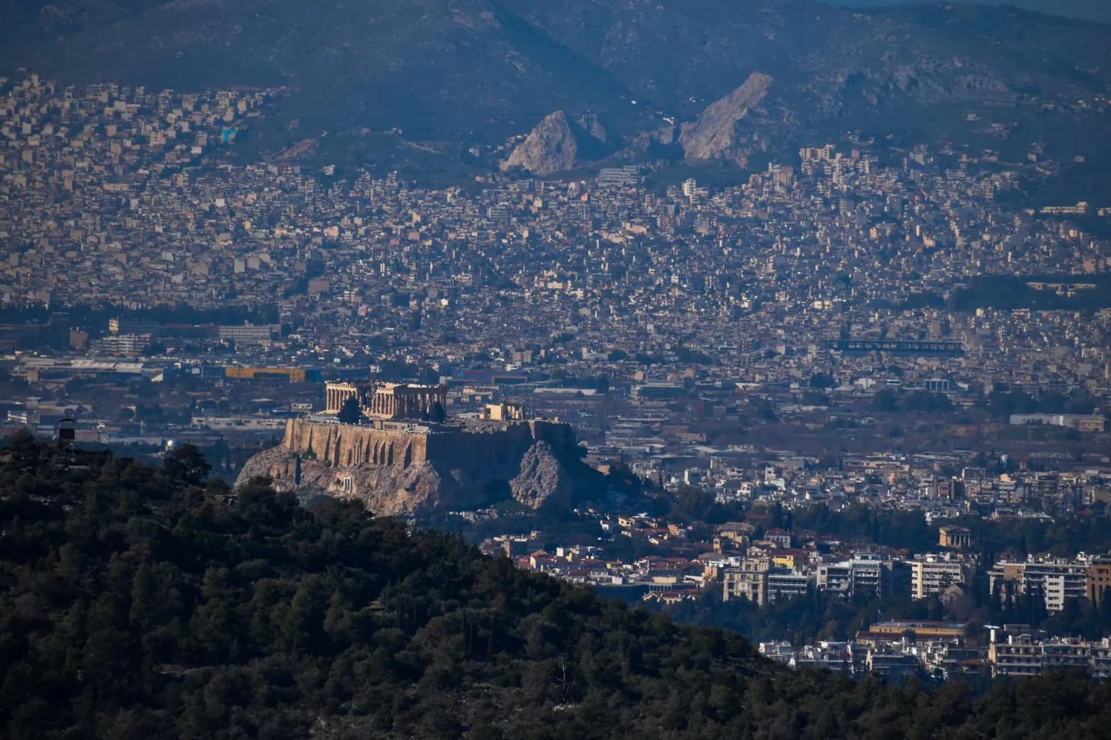
Athens looks enormous from the plane and turns out to be tiny where it counts. The Acropolis, Plaka, Monastiraki and Syntagma sit inside two kilometres of each other. The port and the airport are the two things that are genuinely far away.
Almost every mistake made booking Athens comes from one misreading of the map: people assume a city of three and a half million spreads its sights out the way Rome or London does. It does not. The ancient centre is a single walkable block around one rock, and the sprawl you see from the air is suburbs. Here is where everything sits.
The centre
The centre is a triangle, and you can walk all of it
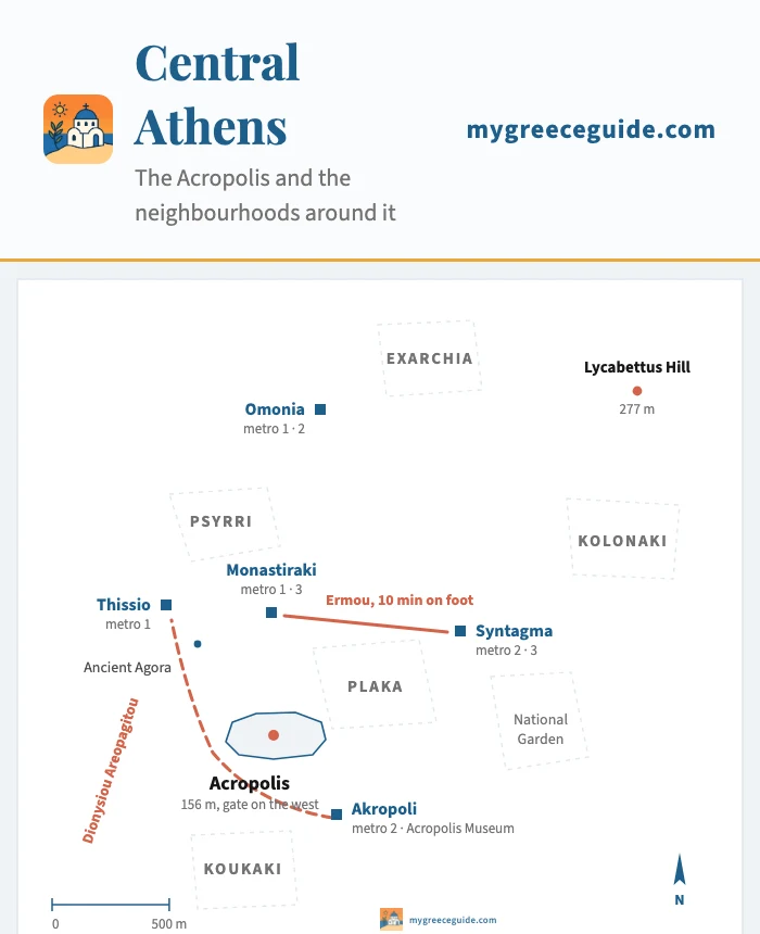
Three points do the orientation work. Syntagma is the modern centre, with the parliament, the airport train and most of the buses. Monastiraki is the old bazaar quarter at the foot of the Acropolis, ten minutes down Ermou from Syntagma. The Acropolis itself is the third point, south-west of both. Draw a line between the three and you have contained nearly everything a first visit needs.
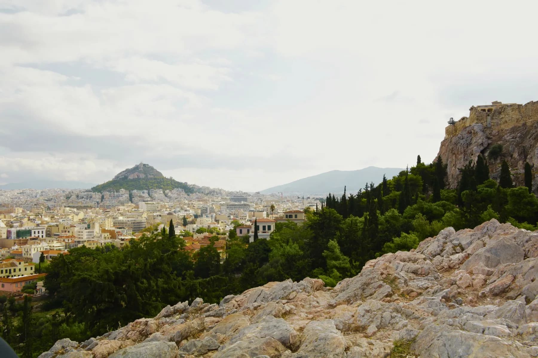
Plaka fills the slope between the rock and Syntagma, so you walk through it whether you meant to or not. Psyrri is on the other side of Monastiraki, closer to the Agora, and it is where people eat late. Kolonaki sits east of Syntagma at the foot of Lycabettus Hill, the second and higher of the two rocks in the middle of the city, which is worth knowing because visitors regularly mistake it for the Acropolis from a hotel window.
The two rocks
The Acropolis Museum is not on the Acropolis. It is at the bottom of the south slope, next to Akropoli metro station, about fifteen minutes below the entrance to the site. The gate to the rock is on the west side, which matters in July: the queue faces the sun and there is no shade on the approach.
Which area to stay in
Because the centre is small, the choice is less about distance than about what happens outside the window at eleven at night.
Pick the kind of stay to place yourself in Athens
What kind of stay is it?
You have one full day for the ancient sites and one evening for dinner, and you do not want to spend either of them on a bus.
Plaka
On the north-east slope of the Acropolis
- Nearest metro
- Monastiraki or Syntagma, 5 min
- On foot
- 12 min to the Acropolis gate
The oldest quarter still standing, and the only one where the streets bend. Prices reflect that, and the lanes fill with day groups from ten to five.
Monastiraki
Between the Agora and Psyrri
- Nearest metro
- Monastiraki, lines 1 and 3
- On foot
- 15 min to the Acropolis gate
One station gets you to the port and the other to the airport, which is why it suits a short trip. The flea market square is loud until late.
The wider map: port, airport and the coast
Athens fills a basin closed by three mountains and open to the sea on the fourth side. That shape explains the whole layout. The port went where the water was, ten kilometres south-west at Piraeus. The airport had to go beyond the mountains, thirty-three kilometres east. The beaches run down the coast south of the port, and the ancient temple at Sounion sits at the tip of the peninsula, seventy kilometres out.
The peninsula
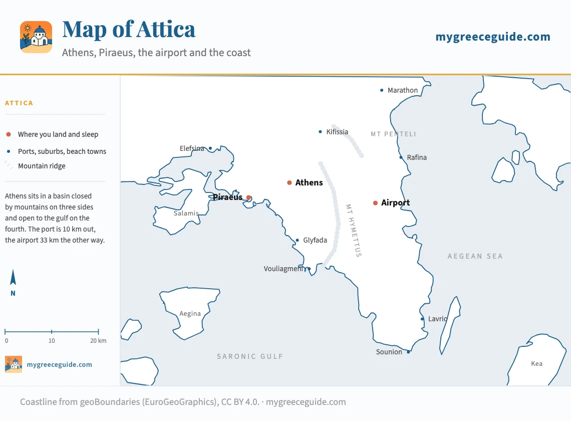
Two ports matter, not one. Piraeus handles the Cyclades, Crete and the Saronic islands, and it is on the metro. Rafina, on the east coast near the airport, handles Mykonos, Tinos and Andros faster and cheaper, but it has no rail link at all: the bus from Pedion Areos takes an hour. Booking a Mykonos ferry without checking which port it leaves from is the classic Athens error, and the two are ninety minutes apart.
What leaves from where is worth settling before you book the hotel. Piraeus runs the main Cyclades line, so the boat down to Santorini leaves from there, and it calls at Paros on the way with Naxos half an hour further on. Milos is the odd one out: it sits on the western Cyclades line, so reaching it from Piraeus means a different boat and a different timetable rather than a stop on the Santorini run.
The two exceptions are the ones that cause the seven in the morning taxi across the city. Mykonos is served from both ports, and which of Piraeus and Rafina your crossing uses is printed on the ticket rather than on the hotel confirmation. Crete is the only overnight in the list: the night boat to Heraklion pulls out of Piraeus late in the evening and docks around dawn, which buys you a night of accommodation and costs you the view.
Athens metro map
Three lines, and the whole network makes sense once you see that its three interchanges form a triangle in the middle of the city. Monastiraki links lines 1 and 3, Omonia links 1 and 2, Syntagma links 2 and 3. If you can name those three you can reach anything without reading a station list.
The metro
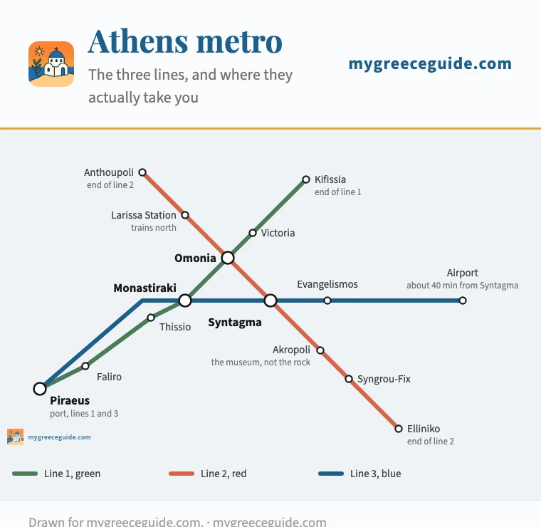
Line 1 is the old one, above ground for most of its length, and it runs from Piraeus up through Monastiraki to the northern suburbs. Line 2 crosses it north to south and stops at Akropoli, the station for the museum. Line 3 is the useful one for arrivals: airport at one end, Piraeus at the other, Syntagma and Monastiraki in between.
Two things catch people out. Only every second line 3 train continues to the airport, so read the destination board rather than assuming. And a standard ticket, at €1.20, covers ninety minutes on everything except the airport, which has its own €9 fare in both directions. Trains stop around midnight, an hour or two later on Friday and Saturday.
How long everything takes
Times outside the morning and evening peaks. Fares change often enough that they are worth a check before you travel, but the ratios between the options hold.
| From | To | How | Time | One way |
|---|---|---|---|---|
| Airport | Syntagma | Metro line 3, direct | 40 min | €9 |
| Airport | Syntagma | Bus X95, 24 h a day | 60 to 90 min | €5.50 |
| Airport | Syntagma | Taxi, fixed fare | 35 to 60 min | €40 day, €55 night |
| Airport | Piraeus | Metro 3, no change since the 2022 extension | about 1 h | Airport supplement applies |
| Piraeus | Monastiraki | Metro line 1 or 3 | 20 min | €1.20 |
| Syntagma | Monastiraki | On foot down Ermou | 10 min | free |
| Syntagma | Acropolis gate | On foot through Plaka | 20 min | free |
| Monastiraki | Acropolis Museum | On foot, south slope promenade | 15 min | free |
| Syntagma | Glyfada | Tram line 6 | 50 min | €1.20 |
| Athens | Cape Sounion | KTEL bus from Pedion Areos | 1 h 45 | €7 |
Athens is the one place in Greece where a car makes your trip worse rather than better. Parking in the centre ranges from expensive to impossible, a ring of the old city is closed to traffic, and an odd and even number plate rule applies on bad air days. The metro reaches the port and the airport, and everything else in the middle is a walk. Rent from the airport on the day you leave for the mainland, not on the day you land.
Where Athens is, exactly
Athens sits at 37.98 degrees north and 23.73 east, in Attica, a peninsula on the eastern side of the Greek mainland that points south-east into the Aegean. On a map of Europe, look at the bottom right: it is level with Sicily and southern Spain, closer to Istanbul than to Rome, closer to Cairo than to Paris. The Peloponnese is immediately west across the Corinth canal, close enough to drive a loop of it, and the Cyclades begin a couple of hours offshore.
Where Attica ends
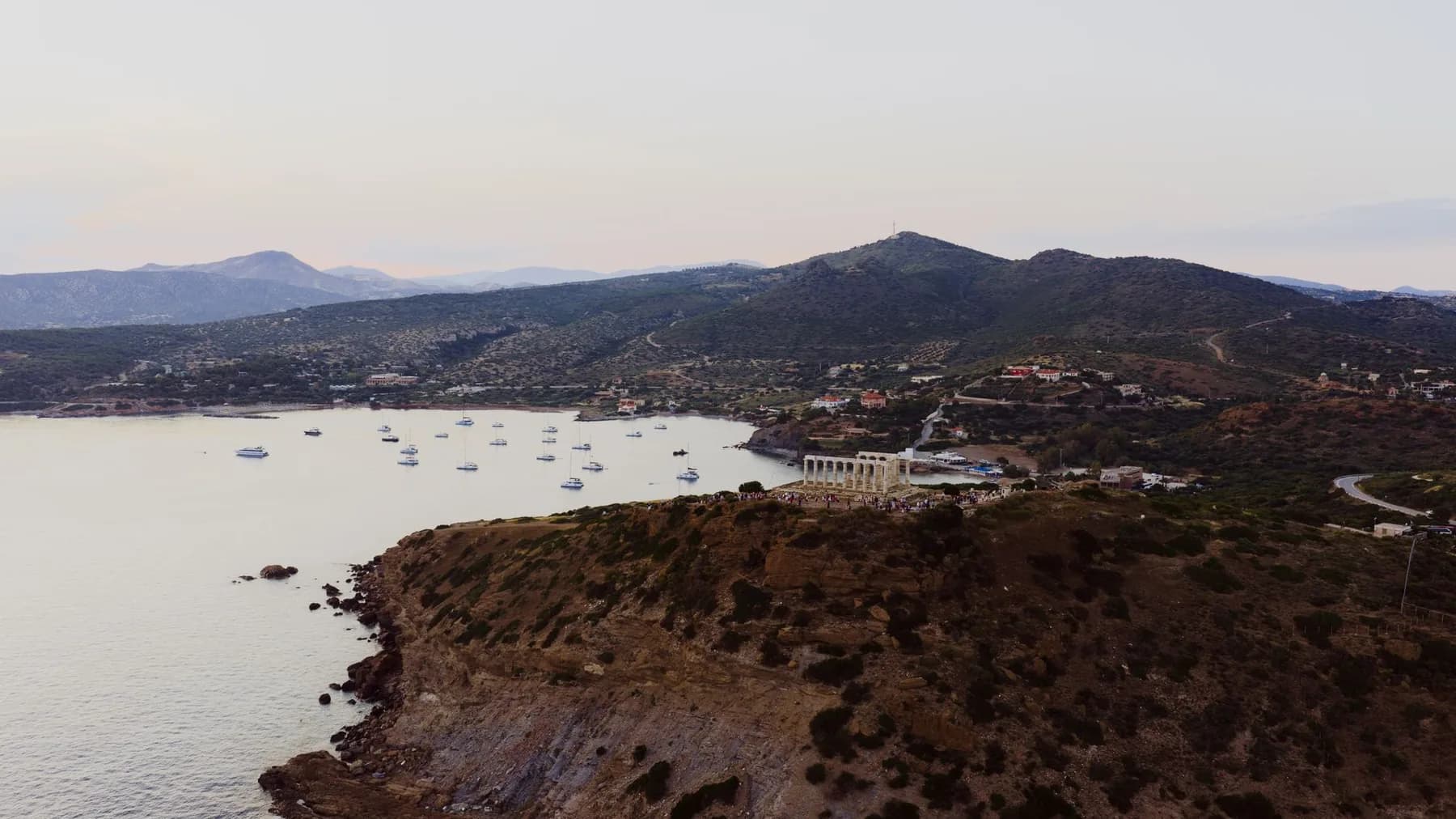
That position is why the city is where it is. A defensible rock eight kilometres inland from a sheltered harbour, with silver mines at Lavrio further down the coast to pay for ships, made a workable naval base. The strait where that fleet beat the Persians in 480 BC is on the map of Attica further up this page: the channel between Salamis and Piraeus.
Questions people ask about the Athens map
Is Athens a walkable city?
The part visitors come for, yes. The Acropolis, the Ancient Agora, Plaka, Monastiraki and Syntagma fit inside a square roughly two kilometres on each side, and a pedestrian promenade, Dionysiou Areopagitou, runs along the south slope of the rock linking most of it. Twenty minutes covers the longest useful walk, from Syntagma to the Acropolis entrance. What you cannot walk is the rest: the port is 10 km out, the beaches 16 and the airport 33. Wear something with grip, because the marble on the hills is polished slippery.
What is the nicest area of Athens?
Plaka is the prettiest and the one everyone means, a village of lanes and bougainvillea on the east slope of the Acropolis, and it is also the most expensive and the most touristed. Koukaki, on the south side by the Acropolis Museum, has the same location without the souvenir shops. Kolonaki, at the foot of Lycabettus, is where Athenians with money live and eat. Pangrati is residential, ten minutes further out, and has the best neighbourhood tavernas. Psyrri is the loud one: excellent late, hard to sleep in.
What is the number one thing to do in Athens?
The Acropolis, and there is no serious second. The rock rises 156 m in the middle of the city, the entrance is on the west side, and the Parthenon on top has been a temple, a church, a mosque and a powder store in turn. Then the Acropolis Museum, which is not on the rock but at the bottom of the south slope next to Akropoli metro, about fifteen minutes below the gate. Go at opening or in the last two hours: there is no shade on the approach and the midday queue in July is the longer of the two waits.
Which metro line goes to the airport, and which one to Piraeus?
Line 3, the blue one, does both. It is the only line that reaches the airport, and it runs through Syntagma and Monastiraki to Piraeus at the other end, so you can go from the plane to the ferry without changing. Line 1, the old green one, also ends at Piraeus. Two catches: only every second line 3 train continues to the airport, so read the destination board, and the airport leg has its own €9 fare while a standard ticket is €1.20 for ninety minutes on everything else.
Where is ancient Athens on a modern map?
Inside a kilometre of the Acropolis, almost all of it. The Ancient Agora sits north-west of the rock, immediately below Monastiraki. Kerameikos, the cemetery and the city gate, is ten minutes further west along Ermou. The Temple of Olympian Zeus and Hadrian's Arch are south-east, between the rock and Syntagma. The Pnyx and Philopappou, where the assembly met, are the wooded hills opposite the entrance. The one piece that has vanished is the Long Walls, which ran 10 km down to Piraeus to keep the city fed during a siege.
